

(Click on image to enlarge)
Image courtesy of the Indiana Geological Survey, I.U. Bloomington.
Well, this is embarrassing. I just realized that if I'd been paying attention when I looked at the 1939 Plat Book, and if it had registered in my brain that "Gary-Hobart Interurban R.R." refers to the streetcar line, I wouldn't have had to schlep my aerial prints over to an old-timer's house to ask if this photo really does show the streetcar line, because according to the plat book, it does. (However, it was a pleasant visit, as always, so I'm not complaining … just embarrassed.)
(Click on image to enlarge)
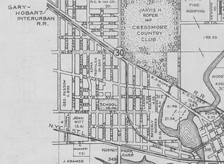
This image from the 1939 Plat Book shows the streetcar line, aka the Gary-Hobart Interurban R.R., running through Hobart. By this time its Hobart terminus was at the northwest corner of Third and Main. From there it ran along the north side of Third Street until it crossed the bridge; then it ran down the center of Third Street. Around Ash Street it moved away from Third Street to cross Connecticut and Pennsylvania diagonally. At First Street (now West Cleveland Ave.) it joined up with Washington and ran down the center of that street up to the Pennsy R.R. There it made a turn and ran along the south side of the railroad tracks until they crossed 37th Avenue, at which point the streetcar line turned west to run along the north side of 37th Avenue straight to Broadway in Gary, where it probably met up with the Gary streetcars, which (I am told) ran up and down Broadway.
If you go to Google maps or Mapquest for a present-day satellite image, it looks to me as if that paved alley moving diagonally northwest from Ash Street is a vestige of the streetcar line, as far as it's diagonal — it soon turns straight north and leaves the path of the streetcar. And maybe I'm seeing things, but there seems to be a slight imprint of the streetcar line left in people's yards on either side of Connecticut, mid-way between Second and Third Streets.
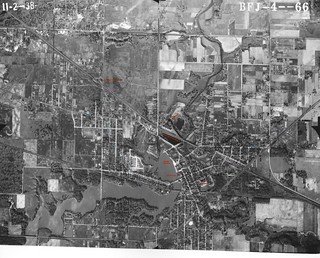
Here's that aerial photo decorated with colored labels. You know how I love doing that. Also a few guesses at what's what.
(Click on image to enlarge)
I've got 6 or 7 more aerial photos that I'll get up here eventually, but this is the most interesting one.


9 comments:
I enjoy all your posts but this was a especially fun one! I really enjoyed searching for the landmarks I was familiar with. I remember the "soccer field under water" as a clay pit dug for the brick works. It was used as the city dump after that--I remember it overflowing. Can you imagine that so close to downtown? Looks great these days . . .
Good heavens, I had no idea that used to be a dump! Downtown must have been pretty fragrant on hot summer days!
I love the aerial photo! It's interesting to see how much the city had changed to the point when I grew up in Hobart (1970s-1990). Thanks!
We moved from Gary to Hobart in 1941 and at that time, there was a diving pier on a small beach in the same location today's Lakefront Park. Check the little square in the photo at that location! I was three at the time and learned to swim there after a time.
I used to live right off of Ash Street and I always thought that angled alley was odd. But now that I think about it, I remember walking down 2nd Street to a friends house on Washington Street, and seeing those diagonal tracks at the Pennsylvania Street intersection. That intersection has been re-paved since then so you can see them now, but it's a cool afterthought. Assuming that they just paved over them, they will eventually be visible again as the road wears.
That should've said "you can't see them now."
My house sits directly on the inter urban on Washington street.. Apparently the tracks are still on my property underneath
Hi! I go to a church in Hobart and work for Gary Transit. I came to your blog while going down a rabbit hole after finding the Krull/Abonmarche building and realizing it’s our old car shop. We are launching a plan for proposed new service into Hobart and the historical parallels are amazing. I’d like to know if it’s ok to cite your blog when we begin outreach later this month. The comments here confirm my theories about the alley north of the 3rd St median terminus and I’m looking for timetables for this line, if anyone has them. History excites me. Transit excites me. So color me very excited!
Please feel free to cite this blog. The Hobart Historical Society museum (706 E. 4th St., open from 10 AM to noon on Saturdays) has a display on the streetcar line and probably has some timetables.
Post a Comment