
Friday I went to the Lake County Recorder of Deeds' office in Crown Point, intending to research the ownership of my house. I found out that Lake County doesn't allow that. They gave me a "transfer sheet" showing the previous owner's transfer to me; beyond that, they told me, I have to go to a title company and pay big bucks for the information.
I haven't talked to a title company yet to find out how big the bucks are. The information may not be worth the price.
On the way back I stopped at the Lake County Central Library and spent three lovely hours in the Indiana Room, looking at old atlases, plat books and city directories.
I learned enough to sketch out an incomplete timeline of the ownership of my pitiful 3.5 acres:
1832 — Potawatomi tribe cedes it to the federal government.
1891 — owned by Henry Chester as part of a larger parcel enfolding the Grand Trunk Railroad in its 274.5-acre embrace.
1926 — owned by C.E. Chester, possibly Charles E., Henry's son; still part of a much larger parcel.
1939 — owned by J. Chester. Possibly James or Jerome, Henry's sons. Still part of a much larger parcel.
1966 — Hubert (probably Senior) and Delilia Lines own this small 3.5-acre parcel carved out of the big parcel that was previously in Chester hands but is now (1966) owned by Chester Wasy.
1979 — owned by Hubert and Carlene Lines (probably Hubert Jr.; Hubert Sr. died in 1977).
1990 — owned by me.
Sources:
♦ Allman Gary Title Company, Atlas and Plat Book of Lake County Indiana (Rockford: The Thrift Press, 1926).
♦ 1891 Plat Book for Appraisers of Real Estate Lake County, Indiana (Valparaiso: Northwest Indiana Genealogical Society, 2007).
♦ Lake County, Indiana, Real Estate Assessment and Transfer Record (10/9/09).
♦ Lake County Title Co., Plat Book of Lake County 1939 (n.p.).
♦ Manich, Steve W., 1966 Township Maps of Lake County, Indiana Showing Ownerships (n.p.).
♦ Manich, Steve W., 1979 Township Maps Lake County Indiana Showing Ownerships (n.p.).
♦ Schoon, Kenneth J., Calumet Beginnings (Bloomington: Indiana University Press, 2003).
Showing posts with label 1830s. Show all posts
Showing posts with label 1830s. Show all posts
Sunday, October 11, 2009

Monday, August 17, 2009
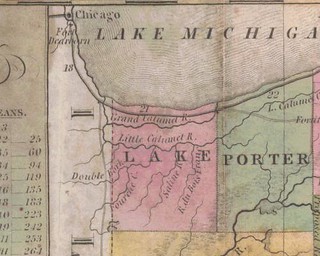
Lake County 1837
(Click to enlarge)
This map comes, via the U. of Alabama website, from J.H. Young, The Tourist's Pocket Map of the State of Indiana, Exhibiting its Internal Improvements, Road Distances, etc. (Philadelphia, S. Augustus Mitchell, 1837).
The map shows Lake County as a vast emptiness containing only rivers, but Lake County was formally organized February 15, 1837. There were hundreds of people living in the county, and Crown Point, for example, was settled in 1835. These may have been squatters on government-owned land; perhaps that was Mr. Young's problem, or maybe he just ran short of ink.
On this map Lake County's southern boundary is not, as at present, the Kankakee River.
Over the counties south of Lake appears the legend "Country Ceded by the Pottawatomies."
I have nothing further to say. You're lucky I said this much. This is one of those days where all I want to do is sleep.
Subscribe to:
Posts (Atom)

