Showing posts with label Hobart Then and Now. Show all posts

Monday, August 5, 2024

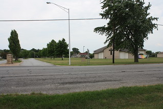
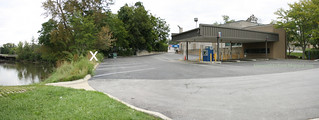
Hobart Then and Now: Third and Wisconsin

Circa 1958, and 2024.

2024-08-05. Lake George Med and Prof Center, 3rd and Wisc, ca 1958 - a
2024-08-05. Third and Wisconsin Apr 2024
(Click on images to enlarge)
Second photo from Google Street View.


I have had that circa-1958 postcard for years, and when I happened to come across the newspaper article about the opening of the Lake George Medical Center in 1955, I decided it was time for this not-terribly-interesting then-and-now.

2024-08-05. 1955-03-17 Gazette, New Hobart Medical Center To Open Monday
(Click on image to enlarge)
Hobart Gazette, 17 Mar. 1955.


By June 1956, an expansion project was underway.

2024-08-05. 1956-06-07 Gazette, Addition To New Hobart Medical-Professional Center
(Click on image to enlarge)
Hobart Gazette, 7 June 1956.


The photo on our postcard above appears to show the post-expansion building, which turned out to be not quite as grandiose as the architect's drawing. I am guessing at about 1958 for that photo, because the lawn and shrubbery have had a little time to grow and settle after the new construction, but the building was still new enough to warrant a postcard. Also, the photographer …

2024-08-05. Lake George Med and Prof Center, 3rd and Wisc, ca 1958 - b
(Click on image to enlarge)

… may have been in business for only a few years in the mid- to late 1950s. "Squire Photo" was the side business of Robley Daniel Squire, whose day job was at the Sears Roebuck store in Gary. The earliest listing I can find for Squire Photo is in a 1956 Hobart directory at the Hobart Historical Society museum, and the latest is in a listing of Hobart businesses as of October 31, 1959, online.[1] (The 1952 directory at the museum lists the Robley Squire family, but no photo business; the 1962 directory lists neither the family nor the business.)

Robley Squire was born in Ohio in 1908 to George and Lydia Squire. Sometime after the 1920 Census, the Squire family left Ohio, and the 1930 Census shows them living on 49th Avenue in Hobart. Robley, then 22, was an apprentice roller in a steel mill.

Soon after 1930, it appears that Robley had a vocation, as we find this surprising announcement in the Burnettsville [Indiana] News of May 18, 1933:

2024-08-05. 1933-05-18 The Burnettsville News - Announces Engagement
(Click on image to enlarge)

From the steel mill to the pulpit! The young couple lived in Logansport at least until 1935, per the 1940 Census, which finds them back in Hobart, and Robley back in a steel mill. Around 1942 their only child, Daniel, was born. By 1950 Robley was a "Division Manager" at Sears. The directory listings mentioned above indicate that they stayed in Hobart through 1959, but not long after that, the family moved to Illinois, to the far-southern suburbs of Chicago.

Here is a picture of Robley in 1969:

2024-08-05. Harvey-Tribune-November,20-1969-p-17
(Click on image to enlarge)
Harvey Tribune (Harvey, Ill.), 20 Nov. 1969.


The ceremony was a family affair, if you read the text.

Robley and Alta now rest from their labors in Illinois. And that is the story of Squire Photo.

And the Lake George Medical and Professional Center was knocked down circa 2006 to make way for the building that is now standing half empty, but half Marco's Pizza, which is delicious.


_______________
[1] "Hobart Businesses — October 31, 1959," Historical Association of Lake County, Indiana Reports and Papers Volume XII (1970), p. 86. https://archive.org/details/reportsandpapersoflakecountyindiana/page/n99/mode/2up

Thursday, April 4, 2024

Hobart Then and Now: The Bale House/A Pink Boutique

Many years ago, I posted a then-and-now shot of the Bale house. Here is another version.

Circa 1900, and 2024:
2024-04-04. Bale002
(Click on images to enlarge)
Historical images courtesy of the Hobart Historical Society, Hobart, Indiana.


2024-04-04. Bale house location 2024 01

2024-04-04. Bale003

2024-04-04. Bale house location 2024 02

The people standing in front of the house in the top photo are not identified, but I'm guessing they are B.B. and Emily Bale. I get the circa-1900 date from handwritten notes on a copy of one of the photos in the historical society's file indicate, and there is nothing in the photos to contradict that. The home was built in 1870.[1] I do not know why the Bales waited some 30 years after construction to get photographs of their house. You'd think they'd do that sort of thing in the first flush of new-home pride. But, of course, photographs were a little more difficult to get in 1870.

Nor do I know when the house was demolished. Per the county assessor's records, the building that houses A Pink Boutique was built in 1950.

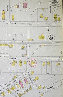
Here is a detail from the 1902 Sanborn map showing the area, with the Bale house circled in red, to give us some idea of what we may be seeing in the background of these photos.

2024-04-04. Bale house on 1902 Sanborn map
(Click on image to enlarge)

The only thing I actually recognize is the steeple of Augustana Lutheran Church, above the head of the man holding the horse in the second photo. Between him and the church, we may be looking at the old wooden Pennsy station.

_______________
[1] That's according to two sources, the Gazette obit of 1927 and the undated 60th-anniversary article, reproduced in my post about the Bales; but the News obit (also reproduced in my post) says the Bales "bought" the house in 1870, suggesting that it had been built earlier.

Saturday, January 2, 2021

Hobart Then and Now: The Pennsy Bridge

This is an update to my 2013 post.

Circa 1906, and 2020
2021-01-02. Pennsy bridge ca. 1906 1
2021-01-02. Pennsy bridge 2020
(Click on images to enlarge)

The original Pennsy Railroad bridge over the Deep River, dating to the 1850s, had charmed generations of Hobart residents and visitors. With its graceful arches, it was a favorite of photographers and artists.

In 2018/2019, it was demolished and replaced by a new bridge that has plenty of water capacity but zero charm.

♦    ♦    ♦

I have two real-photo postcards with this view of the original bridge. The one above is the clearer of the two, but the year in its postmark is illegible. Here is the other one, postmarked 1906:

2021-01-02. Pennsy bridge ca. 1906 2a

I find this one interesting for its message — the writer says "these views" are taken by one of her "old pupils." So evidently she is or was a teacher, and her name is Maude. I went looking in the 1900 and 1910 censuses for a schoolteacher named Maude, and found Helen Maud Quinnell (she was Maud in 1900 and Helena in 1910). She appeared among the faculty in the first Hobart High School annual in 1908.

2021-01-02. Quinnell, Helen Maud 1908
(Click on image to enlarge)
Image courtesy of the Hobart Historical Society.


In the 1900 census she described herself as a schoolteacher, but in the 1910 census, she gave her occupation as "none."

I remember coming across that name — Quinnell — now and then in my newspaper reading, but never in connection with anything juicy. Helen Maud was born in 1880 in Illinois. Her father was H(arry) T(homas) Quinnell, her mother Anna (Bridgman). She had two younger sisters, Beatrice and Blanche (we've previous seen a photo of Blanche as a member of Hobart High's class of 1904). The family left Illinois sometime after 1888;[1] the 1891 Plat Book shows them owning a farm of some 30 acres just southeast of Lake Station. They still owned it per the 1908 Plat Map:

2021-01-02. Quinnell 1908
(Click on image to enlarge)

After the 1910 census, I lose track of all the Quinnells.


As for the photographer, the "old pupil" whose hand may have written the caption on both postcard images — I don't have a clue.

_______________
[1] That is the latest date when I can find H.T. registered to vote in Cook County, Illinois, per Ancestry.com.

Wednesday, March 20, 2019

Hobart Then and Now: Center Street North from Third

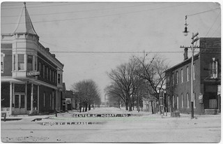
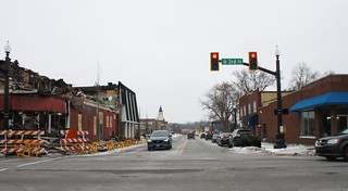
Circa 1909, and 2019

2019-03-20. Center St from 3rd 1909-07-30 a
(Click on images to enlarge)

2019-03-20. Center St from 3rd 2019

This is a depressing update to my previous then-and-now post of the Guyer building.

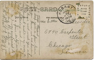
The top photo comes from a postcard postmarked 1909.

2019-03-20. Center St from 3rd 1909-07-30 b

The photo doesn't tell us much about what businesses occupied either of the two commercial buildings on the corners, except that Dr. Fred Werner had his dental office there.

The building on the right might have already been the Amazon restaurant. Somehow, I have the impression that this is where, a few years earlier, Hans Thune had operated the Farmer's Home, but I may be mistaken.

Further down Center Street on the same side is the Rifenburg/Mackey house.

And looking straight up Center Street, you can see in the background the smokestack of the National Fireproofing Co. brickyard.


As those of us in Hobart know, the Guyer building was badly damaged by fire on the night of January 15, 2019. Then the second floor had to be knocked down because it was unstable. I am not sure whether the building's ultimate fate has been decided yet.

Friday, November 23, 2018

Hobart Then and Now: Lillian Street from Ohio

Circa 1910, and 2018

2018-11-23. Lillian St. ca 1910
(Click on images to enlarge)
2018-11-23. Lillian St 2018

We are standing at the intersection of Lillian and Ohio Streets, looking northwest toward S.R. 51.

The photo is by August Haase, so we know it was taken between 1902 and 1913. Accord to the county records, the house now standing at the corner in the foreground was built in 1909 (all the structures beyond it in that block were built in the late 19th century). Is the 2018 house the 1909 house after a century of remodeling? It looks possible.

Here's the verso of the postcard:

2018-11-23. Lillian Street 002

The stamp box style, according to playle.com, dates between 1908 and 1924.

All things considered, I'm going to estimate this photo at circa 1910, give or take a couple of years.

The writer tells us that the dot over the second house from the corner shows us where "Eva" lived. But who was Eva? The 1910 Census shows two Evas on Lillian Street.

One was Eva (Kitchen) Bowen, wife of William Boyd Owen, Jr., brickyard superintendent. I have been told that the "Owen house" is on Lillian north of S.R. 51 … but were all the Owens confined to that area?

The other was Eva (Darling) Miller, who was born circa 1887 in Ohio (hence, maybe, the Ohio connection with the postcard's addressee?). By the 1900 Census her family had moved to Kosciusko County, Indiana, where in 1906 she married Jesse Miller. By 1910 the young couple were living in Hobart, but the 1920 Census records them back in Kosciusko County.

It could be either, as far as I know, but I have a feeling it was Eva Miller.

Thursday, November 2, 2017

Hobart Then and Now: Dr. Pliny P. Gordon's House

1898, and 2017:
2017-11-2 Gordon, Dr. P.P 1898
2017-11-2 Police station parking lot
(Click on images to enlarge)
Top image courtesy of the Hobart Historical Society.


Since the location of this Gordon house is not general knowledge (I certainly didn't know it until very recently), I should set out my reasons for concluding that it stood on the east side of Center Street, slightly south of the Fourth Street intersection.

To establish that the house was on Center Street, here's a little item from the "Local Drifts" column of the Hobart Gazette of July 4, 1902: "Mr. and Mrs. Howard Gordon came out from Chicago last Saturday to live in Hobart and have begun housekeeping in his father's house on Center street." We can refer to the 1880 Census or P.P. Gordon's 1904 obituary (below) to confirm the relationship between Howard and Pliny.

Fortunately for posterity, the Hobart Gazette's 1898 Souvenir Edition reproduced a photograph of the house and identified it, and also fortunately, as we can see in the photo above, it was a fairly distinctive house — brick, two full stories, with a bay window in front (and on your left as you stand in the street facing the house), a small front porch next to it, and a small bay window towards the rear on the right side. So let's look at the Sanborn map of 1895 to see if we find a house like that.

2017-11-2 1895 Sanborn map detail

Almost a match: it's colored red, so it's brick; most of it is two full stories; the bay window in front would be on your left as you faced the house. But what about the side bay window and the small front porch? Let's go to the 1902 Sanborn map:

2017-11-2 1902 Sanborn map detail

Now we have the front porch and the side bay window. We know they were sometime after 1895, so they could have been there for the 1898 photograph.

Speaking of which, if we look carefully at the background of that 1898 photo, we can see that at some distance behind the house is a large structure, over two stories, with a gable topped by a chimney on the side facing the house. I think that's the Hobart Township School on Fourth Street; compare this 1894 photo and this circa-1900 photo.

That's my case for the location of the P.P. Gordon house.

♦    ♦    ♦

Porter and Lake Counties (Goodspeed/Blanchard) included a biographical sketch of P.P. Gordon:
PLINY P. GORDON, M. D., senior member of the firm of P. P. Gordon & Bro., druggists and grocers, was born December 21, 1835, in Pennsylvania, and is one of eight children born to Edwin and Lucy (Power) Gordon, the former of New York, and the latter of Vermont. Grandfather Gordon was in the war of 1812. Two uncles were noted physicians of Detroit and Harrisburgh. When Pliny P. was four years old, his parents came to Michigan; here he lived at home until about 1860, attending school at the Ontario (Ind.) Seminary; he then began the study of medicine under Dr. Warren Byrns, of Bronson, Mich., and studied also at Ann Arbor and Buffalo, and graduated at Buffalo in the spring of 1865; he then came to Hobart and located; the first year he had a $1,200 practice, and has since run as high as $3,500; three years later, he began the drug business in partnership with his brother, and has been in that ever since; the firm has also been engaged in buying land, and at present the brothers have two farms; they have a fifth interest in the Deep River Ice Company. The Doctor is the oldest practitioner in Hobart, and has a leading practice in this part of the county. He is a Knight Templar, member of the F. & A. M. fraternity, and has been a member of the I. O. O. F. lodge; he was County Coroner for two years; he has always been a Democrat, and is a public-spirited citizen. He was married, in December, 1869, to Hettie Rifenburg, a native of New York. They have one child, Howard B. Mrs. Gordon was a teacher for a number of years.
Hettie Rifenburg was the sister of William H. Rifenburg. Much of this sketch was repeated in the doctor's obituary, printed in the Hobart Gazette of March 18, 1904:

2017-11-2 obit of P.P. Gordon

I believe that Mary McAfee was the widow of Samuel (1880 Census) and her maiden name was Russell (Indiana Marriage Collection). Dr. Gordon only flitted through the last year-and-a-half of her life.

The 1979 article that was the basis of my Downtown Hobart 1979 blog included a story involving the Gordon brothers, set in the 100 block of Main Street:
Lot #1 of Hobart's plat was the site of Lew Hammond's tavern, a stage coach stop. In 1886 it was run by Mrs. David Young as Young's Hotel. John Gordon came from Pennsylvania that year to visit his brother, Dr. Pliny Gordon. He walked from the Pennsylvania Railroad station down Front Street and inquired at the hotel where he could locate his brother. He was told he was upstairs at a dance. John Gordon bought a ticket for $2.50 and was handed a slip of paper. This, he was told, was a deed to a lot in the new cemetery on Front Street and the dance was being given to raise money to build a fence around the cemetery to keep the pigs and cows from grazing there. Mr. Gordon relates the hotel later burned down.
I do not know the identity of the Mr. Gordon relating this story. It appears he misremembered the year, since John Gordon was already well settled in Hobart by 1882, when Goodspeed and Blanchard printed the biographical sketch above.

From a family tree on Ancestry.com comes this 1903 picture of Pliny Gordon and his first grandchild, Virginia (born in November 1902):

2017-11-2 Dr. Pliny P. Gordon  1903 and granddaughter Virginia
Image credit: "KatharineMRedmond," Ancestry.com.


If the photo is correctly dated to 1903, that's likely a christening gown Virginia is wearing as she sleeps in Grandpa's arms, before or after the ceremony. The overexposure of the photo makes it very difficult to judge the baby's age. If the photo dates to January 1904, then her christening gown has become her burial gown.

Little Virginia died January 17, 1904, just a couple of months before her grandfather. They are both buried in Hobart Cemetery.

Monday, April 17, 2017

Hobart Then and Now: Eighth and Garfield

Ca. 1909-1917, and 2017

2017-4-17. 8th Street Hobart a
(Click on images to enlarge)
2017-4-17. 8th and Garfield 2017

We are on Eighth Street, looking east toward Garfield Street.

The house on the far side of Garfield is the newest one in the photo, built in 1909 according to the county records. The house just east of it was built in 1900. The barely-visible house beyond (on the east side of Linda Street) was built in 1874; notice the windmill sticking up behind that house. The one in the foreground was built in 1907.

The house that now stands immediately north of the 1909 house was built in 1917. It hadn't been built yet when the first picture was taken — that is why we can date that picture between 1909 and 1917. Since the ground around the 1909 house looks as if it had had at least a summer's growth after the building process, I'm inclined to think the photo dates to 1910 or later, but that's speculation.

Nothing on the verso helps us date the card.

2017-4-17. 8th Street Hobart b


I think the house with the windmill is shown on the 1874 Plat Map as belonging to William Franck (more commonly spelled Frank).

2017-4-17. Frank 1874

Tuesday, November 1, 2016

Hobart Then and Now: Radio Field/Southlake Mall

1937, and 2016

2016-11-1. rf007
(Click on images to enlarge)
Image above courtesy of the Eldon Harms family.

2016-11-1. Southlake 1
2016-11-1. Southlake 2

I can't do a precise then-and-now shot because I can't identify exactly where the first photo was taken. Thanks to notes on the back, we know the year — 1937.

2016-11-1. rf008

"Les" is Lester Harms (with his back to the camera), and "Dad" is his father, John Harms (in the driver's seat). They did not own this land; they may have rented it, or plowed it for hire. The field was called "Radio Field" because there were radio towers somewhere in it.

In the 1937 picture, there seems to be a road in the right background, with a house and farm outbuildings in the distance. We don't know which road that is, or whose house.

I never had a chance to look at this picture with Eldon Harms. It had been mislaid in his house, and in spite of the time he spent searching, it didn't turn up until after he had gone. "Where Southlake Mall is now," is how he described it, and "near I-65." I'm not sure if he himself, looking at the photo, could have told me exactly where it was taken.

Friday, July 29, 2016

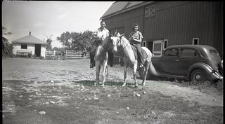
Hobart Then and Now: Bracken Riding Stable

Circa 1940, and 2016.

2016-7-29. st099
2016-7-29. sort of approximately in the vicinity of the Bracken stable
(Click on images to enlarge)
Top image courtesy of Eldon Harms.


The 2016 photo is vaguely approximate. Don't start telling people that the Barrington Ridge Baptist church is on the site of the old Bracken riding stable. Of course I asked Eldon Harms when we were looking at this photo, but he could not remember the exact location of the stable — only that it was along S.R. 51, north of where the CVS store is now.

And my guess at circa 1940 is very approximate, too. The car in the photo, Eldon told me, is a 1935 Ford, so the date must be 1935 or later; something about the (unidentified) woman's hair says "World War II" to me, but that's just a vague impression.

The sign above the stable door reads:

BRACKEN
INDIAN RIDGE STABLES
SADDLE HORSES FOR HIRE
BY THE HOUR
INSTRUCTION IF DESIRED


Eldon remembered the Bracken riding trail as going along 14th Street … or maybe going before 14th Street.

Monday, April 18, 2016

Hobart Then and Now: Nickel Plate Bridge

Ca. 1906, and 2016:

2016-4-18. Bridge 001
2016-4-18. Nickel Plate bridge 2016
(Click on images to enlarge)

Thank goodness the sender wrote those identifying notes — I would never have recognized the first photo as Hobart. Even with the notes, I have to take her word for it. The best I can say is that I don't see anything in the 1906 photo that would rule out Hobart. (And you can see a smokestack about where you would expect the brickyards to be.) The bridge looks like a railroad bridge, as opposed to the Third Street bridge, so I'm guessing Nickel Plate, and that assumption fits with the view of the buildings that make up downtown; also, there's a water tower on the opposite side of the river, which would be needed by steam engines.

You cannot stand where the circa-1906 photographer stood and get anything remotely resembling that photo. The riverbank is steeper now and heavily overgrown, and the Norfolk Southern bridge has become a massive earth-and-cement structure that constricts the river and blocks your view of the town. I had to stand up higher, nearer to the tracks.


Here's the verso, with the 1906 postmark.

2016-4-18. Bridge 002

I have no idea who any of these people were.

Wednesday, March 30, 2016

Hobart Then and Now: Library/Museum Interior

1922 and 2016

2016-3-30. Library interior 001
2016-3-30. Library interior 2016
(Click on images to enlarge)

This is the east-side interior of the Hobart library, now the Hobart Historical Society museum.

I like the fresh flowers on the tables in the 1922 photo — lilacs on the table nearest the fireplace, I believe. The library had plenty of shelf space in those days.

Perhaps the photo doesn't date precisely to 1922, but the message on the verso does:

2016-3-30. Library interior 002

The signature may be "Harold Ray" or "Harold & Ray"; either way I can't identify the writer.

Sunday, December 21, 2014

Hobart Then and Now: Villa Rose Tavern

Circa 1946-1956, and 2014.

Villa Rose Tavern
Hobart Trustee's office
(Click on images to enlarge)

Formerly the Villa Rose Tavern, now the Hobart Township Trustee's office, at 1421 W. 37th Avenue in Hobart.

I just recently bought this postcard. It is unused, and I couldn't find anything on the back that would help me date it.

Villa Rose Tavern postcard verso

Checking some of the old directories at the Hobart Historical Society, I found it listed no earlier than 1946 and no later than 1956. So that's how I estimated the date of the photo: very superficial research.

The 1920 Census and 1930 Census show a John Kiefer (born 1910) living on a farm in Ross Township, but I have no clue whether it's the same person.

Sunday, September 14, 2014

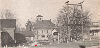
Hobart Then and Now: The Mill Business

Circa 1947, and 2014:
Mill site ca 1947
Mill Site 2014
(Click on images to enlarge)
Top image courtesy of E.H.


We've already seen a then-and-now of the old mill's picturesque side. This one's for the business side.

I wish I knew the actual source of the top photo, so I could credit it properly; but that photo comes down to us as a page cut out from some unknown publication and placed in a photo album, the owner of which was kind enough to let me scan it.

Said owner once worked in the mill, and on the night of February 15, 1953, stood in the driveway leading into the mill complex (where the red "X" is) and watched it burn. He told me that driveway was approximately where those blue panels are in the windows of the bank building.

It's his identification of the various buildings and their functions that I've previously linked to the Downtown Hobart blog.

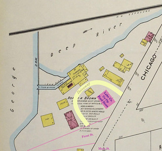
Here is my extremely crude attempt to update the 1922 Sanborn map to show the location of the Lake County Co-Op feed store in the circa-1947 picture, as well as the driveway that wound through the complex.

Mill site 1922

Here is the site today, viewed from the west. The "X" marks roughly where the mill itself was. (Very roughly.) Water actually flowed under part of the mill, I'm told.

Mill site 2014 from back