

(Click on images to enlarge)
Top image courtesy of E.H.
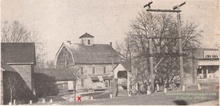
We've already seen a then-and-now of the old mill's picturesque side. This one's for the business side.
I wish I knew the actual source of the top photo, so I could credit it properly; but that photo comes down to us as a page cut out from some unknown publication and placed in a photo album, the owner of which was kind enough to let me scan it.
Said owner once worked in the mill, and on the night of February 15, 1953, stood in the driveway leading into the mill complex (where the red "X" is) and watched it burn. He told me that driveway was approximately where those blue panels are in the windows of the bank building.
It's his identification of the various buildings and their functions that I've previously linked to the Downtown Hobart blog.
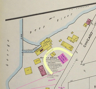
Here is my extremely crude attempt to update the 1922 Sanborn map to show the location of the Lake County Co-Op feed store in the circa-1947 picture, as well as the driveway that wound through the complex.
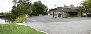
Here is the site today, viewed from the west. The "X" marks roughly where the mill itself was. (Very roughly.) Water actually flowed under part of the mill, I'm told.


No comments:
Post a Comment