Showing posts with label Frank. Show all posts

Monday, March 28, 2022

The Phantom Road

I have always been puzzled by the fact that the Ross Township plat maps — from the earliest we have onward through the mid-20th century — all show a public road where today there is none.

Here is that road on the 1874 Plat Map. It runs north and south along the section line between Sections 12 and 7, except where it bows out westward to avoid Sprout Ditch, and it connects present-day 61st and 70th Avenues.
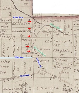
2022-03-28. Unidentified road, Ross1874
(Click on image to enlarge)

I had to draw in 70th Avenue myself, since it doesn't show up on this map, except for that brief east-west line connecting DeKalb and the phantom road.

Naturally I wondered whether the 1874 cartographer made a mistake. That would not be the only possible error I've encountered on a plat map. Perhaps subsequent mapmakers didn't bother to verify and just copied the original error.

However, I recently came across an announcement in the microfilm newspapers that throws a wrench into the works of the "mistake" theory.

2022-03-28. Vacation of Highway, Gazette, 3-16-1933
(Click on image to enlarge)
Hobart Gazette, March 16, 1933.


The announcement mentions the surnames of three property owners whose land is adjacent to the road: Frank, Paine, and Sievert. Those match up with the property owners shown in the 1939 Plat Book.
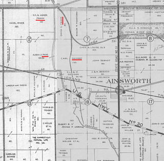
2022-03-28. Unidentified road, Ross 1939
(Click on image to enlarge)
I had to patch two pages together.


The announcement names Henry Sievert, while the plat map shows Carl Sievert owning the land, but I think the plat map just hadn't caught up with the reality that Carl had died in 1929 and his son, Henry, now owned the land.


The announcement seems a little garbled — its heading and opening line specify "vacation" of a highway — that is, abandonment — but it goes on to speak of a "proposed highway" that "will pass through" the described land, as if the road were to be built, not abandoned. And then it says the highway is, or will be, 66 feet in width! That's quite an impressive highway. I'm inclined to think that there was a little carelessness in the drafting or the typesetting of the announcement, rather than that a 66-foot-wide local road was proposed to be built during the Great Depression.

I have searched in vain in the Hobart papers for any information about the outcome of the April 4 hearing mentioned in the announcement. Was the highway officially vacated?

As we see above, the 1939 Plat Book still seems to take notice of a public road there. On the 1939 aerial view, we can still trace the line of the road …

2022-03-28. unidentified road 1939 aerial view
(Click on image to enlarge)
Image via Indiana University's Indiana Historical Aerial Photo Index.


… though it doesn't appear to connect directly with 70th Ave. (and it certainly is not 66 feet in width).

The road is drawn on the 1950 plat map , but not on the 1972 plat map.

Today, if you really zoom in on the Google satellite view, you can see that a wagon-wheel sort of path, probably used by farm machinery, still follows the line of the abandoned road.

That road would come in handy when both the DeKalb Street and the 70th Avenue crossings of the Canadian National Railroad are blocked by freight trains. As this area gets ever more developed, perhaps someday the road will be un-vacated.

Thursday, May 9, 2019

The Golden Foxes and the Frank Aunts

Here's a nice cheerful post where nobody dies.

John and Anna Fox, having sold their farm on Cleveland Avenue, are still living somewhere on that street.

2019-05-09. Fox, Gazette, 7-27-1923
(Click on image to enlarge)
Hobart Gazette, July 27, 1923.


I suppose we don't care about Mrs. Fox's maiden name (Peters) since her people aren't local.

The little item in the right-hand column helps me just slightly with the mysterious Mulfinger connection. It also brings in the name Apfelbach, which means "apple creek," which is cute, but I think she's a Chicago person too.

(Just below that item we get back into depressing territory, with John and Minnie Berndt recovering from the diphtheria that killed their little daughter.)

Tuesday, November 27, 2018

Fats-v.-Leans Baseball

This game in June of 1923 was not the first fats-against-leans game that I've seen. And on holidays such as Independence Day, you might also find foot-races going on — one for the "fats" and one for the "leans." Anyway, in this case the News has left us with a record of the body type of a number of Hobart's male citizens, in case we had no photograph and were wondering!

2018-11-27. Fats v Leans, News, 6-28-1923
(Click on image to enlarge)
Hobart News, June 28, 1923.


Sorry I failed to get the beginning of the story.

As we see from the little item below the summary of the game, Hobart had another team called the Cardinals.

♦    ♦    ♦

Back when I was talking about the Frank family, I wondered about the Mulfinger connection. This item in the right-hand column helps a little. Not much.

Sunday, May 27, 2018

Moses Frank, Brickie

Among the siblings of F.F. Frank was a brother named Moses, who was born in Michigan in 1852, died in Hobart in 1874, and was buried in the Hobart Cemetery.

This is not that Moses Frank. This is the other Moses Frank of Hobart.

2018-5-27. Frank, Moses
(Click on images to enlarge)


This Moses Frank was born in Canada in 1848. Per the 1910 Census, he came to the U.S. in 1862. He seems to have been in Indiana by 1865. I do not know whether he came directly to Hobart — and if so, he was away for several months in the Union Army, having joined as a substitute in March 1865[1] — but by 1868 he had been here long enough to court Sarah Peters, who married him the day after Valentine's Day (Indiana Marriage Collection).

2018-5-27. Frank, Sarah (Peters)

Sarah's parents were native to New York, then moved their family to Michigan where Sarah was born circa 1847, but moved back to New York by the 1850 Census and were still there in 1855.[2] When Moses arrived in Hobart, Sarah's family had been farming locally for at least two years (1860 Census).

The 1870 Census shows the young couple keeping house in Hobart; Moses worked as a "brick maker." Sarah's sister Debby, a dressmaker, is listed in that household.[3]

When the 1880 Census came around, Moses was still making bricks. He'd also made a couple of children (May Zaretta and Winfield). His mother, Hannah, lived in his home.

Sometime between 1880 and the 1900 Census, Moses left Hobart and brick-making forever. He and Sarah moved to Chicago and he went into the railroad-car-inspecting business. Moses died in 1917, Sarah in 1931, and both are buried in Chicago.

These photographs are undated (and I have failed to trace the photographer), but judging by Sarah's very full sleeves I'd say they were taken in the late 1890s.

If there is any family connection between this Moses Frank and the other Moses Frank, I have not uncovered it.

I guess the point is … once a brickie, not always a brickie. Or maybe there is no point, but I bought these photos a long time ago and so obviously I simply had to write a blog post about them. Yes, sometimes I even bore myself with this stuff.

_______________
[1] Historical Data Systems, comp. U.S., Civil War Soldier Records and Profiles, 1861-1865 [database on-line]. Provo, UT, USA: Ancestry.com Operations Inc, 2009.
[2] Ancestry.com. New York, State Census, 1855 [database on-line]. Provo, UT, USA: Ancestry.com Operations, Inc., 2013. Original data: Census of the state of New York, for 1855. Microfilm. New York State Archives, Albany, New York.
[3] Deborah is also listed in the household of her parents, who were still farming near Hobart. By the 1880 Census, it appears that all members of the Peters family had either left the area or changed their surnames, except possibly brother George. After 1880, I lose all track of them.


Thursday, May 24, 2018

Speaking Frankly

Since I learned that the house on the northeast corner of Linda and Eighth Streets was the Frank house, I have gotten interested in the Franks. Here is F.F. Frank getting his birthday in the news in 1923.

2018-5-24. Frank
(Click on image to enlarge)
Hobart Gazette, April 27, 1923.


Since the item doesn't give his age, we have to do some research ... it turns out that per his Indiana Death Certificate, Franz Fredrick Frank (no wonder he went by his initials!) was born April 22, 1859 to William and Salinda Frank — who likely built the house at Linda and Eighth, in 1874 per the county records. So F.F. was celebrating his 64th birthday.

F.F. had married Lydia Bach in 1890 (Indiana Marriage Certificates), hence the Bach connection. Lydia's sister, Henrietta, married Henry Kuehl. As for a Mulfinger connection, I haven't looked into it and don't intend to, not with my slow internet!

♦    ♦    ♦

The story directly below the Frank birthday got me wondering where the Charles Berndt house was, and whether Charles was related to the Ainsworth-area Berndts. I believe the answer to the second question is yes, since it appears that Charles and John (Jr.) were children of John (Sr.) and Hannah (e.g., 1900 Census). (And their sister, Bertha, married a Rossow.)

To find Charles' house, we need to find a Berndt farm west of Hobart, beside the Nickel Plate tracks … like this:

2018-5-24 Berndt 1926
(Click on image to enlarge)
From the 1926 Plat Book.


The home that sits on the east side of Liverpool Road, north of the railroad tracks, was built in 1923 according to the county records, so perhaps it was built by Charles to replace the one that burned down.

Sunday, March 18, 2018

Now, About All Those Other Guys

Mayor Sherman Henderson's instructions to Police Chief Fred Rose in early April 1923 testified that, in spite of all those recent acquittals, plenty of people in Hobart were selling and buying vice in the form of liquor and gambling.

2018-3-18. Punchboards etc.
(Click on image to enlarge)
Hobart News, April 5, 1923.


I had to ask Professor Google what punch boards are. In his letter, His Honor sounds as if he were still mad about losing money on them.[1]

In the left-hand column, we find another type of eradication underway, as local cattle were getting tested for tuberculosis, and many failing.


_________________________________
[1] I'm kidding.

Sunday, July 2, 2017

Nuts to You

While indexing the Hobart Historical Society's earliest Union Sunday School record book, which appears to begin in 1868, I came across this page. Some earnest person carefully recorded something (attendance?) about these young* Sunday scholars … and then some irreverent person came and scrawled "nuts to you" and perhaps left those smudges with his or her dirty hands.

2017-7-2. USUN1868-009, 010 - nuts to you
(Click on image to enlarge)
Image courtesy of the Hobart Historical Society.


The expression, "nuts to you," seems out of place in 1868. We know it was in use in 1930s-40s — I keep running across this example:
"Please eliminate the expression 'nuts to you' from Egbert's speech." [Request from the Hays Office regarding the script of "The Bank Dick," 1940]**
However, my internet research doesn't turn up any information about how far before 1940 it goes back. So I shouldn't jump to conclusions. But I picture a bored 13-year-old circa 1940 nosing around in the attic when the adults were away, finding this ancient record of good little children, and writing something impertinent for the sheer fun of it.

________________
*Just to look at a few: John Shearer would have been about 12 years old in 1868; George Shearer, 10; John Frank, 11 (he was the son of William and Salinda Frank; and Simeon Brown, 13.
**E.g., http://www.dictionary.com/browse/nuts.

Monday, April 17, 2017

Hobart Then and Now: Eighth and Garfield

Ca. 1909-1917, and 2017

2017-4-17. 8th Street Hobart a
(Click on images to enlarge)
2017-4-17. 8th and Garfield 2017

We are on Eighth Street, looking east toward Garfield Street.

The house on the far side of Garfield is the newest one in the photo, built in 1909 according to the county records. The house just east of it was built in 1900. The barely-visible house beyond (on the east side of Linda Street) was built in 1874; notice the windmill sticking up behind that house. The one in the foreground was built in 1907.

The house that now stands immediately north of the 1909 house was built in 1917. It hadn't been built yet when the first picture was taken — that is why we can date that picture between 1909 and 1917. Since the ground around the 1909 house looks as if it had had at least a summer's growth after the building process, I'm inclined to think the photo dates to 1910 or later, but that's speculation.

Nothing on the verso helps us date the card.

2017-4-17. 8th Street Hobart b


I think the house with the windmill is shown on the 1874 Plat Map as belonging to William Franck (more commonly spelled Frank).

2017-4-17. Frank 1874

Saturday, November 30, 2013

Long-Timer Gone, Short-Timer Back

Carl William Bach was a long-time Ross Township resident whom I completely ignored until he died. By comparison, William Wollenberg, Jr. — now back for a visit — was a short-timer, and yet I've written loads about him and his saloon-keeping family.

C.W. Bach
(Click on images to enlarge)

It took me a long time to figure out where the Bach homestead was. You'd think people who had been here since 1846 would have acquired more land than this: [12/1/13 update: They did. The DeWell family archivist points out that I missed a second 40-acre Bach parcel, outlined in green on the map below. Now I don't know which parcel to get all sentimental over. And I can't figure out which road the green parcel sits on — W. 86th? W. 89th?]

Bach land 1908

The daughter, Mrs. Henry Kuehl, mentioned in the obituary as living with him was the former Henrietta "Hattie" Bach. She had married Henry Kuehl in 1896 and left the old homestead for a few years, but by 1910 she and Henry had come back. In the intervening years, her brother, George, and his wife and children had lived with their father. So as far as I know Carl William Bach was never alone there.


Sources:
♦ 1900 Census.
♦ 1908 Plat Map.
♦ 1910 Census.
♦ 1920 Census.
♦ Indiana Marriage Collection.
♦ "Local and Personal." Hobart News 6 Jan. 1921.
♦ "Obituary." Hobart Gazette 7 Jan. 1921.
♦ "William Bach." Hobart News 6 Jan. 1921.

Saturday, July 21, 2012

Farm Buildings and Buyings

The Price family set about improving the farm they had recently bought. By early August 1919, they had hired numerous local contractors to do work for them:
F.B. Price of Ross township has given the contract to Wall & Fleming for the building of a new house and barn, including half a dozen outbuildings on his farm which he recently purchased from W.O. Halsted. The cement contract goes to Vincent Boyd and the electrical wiring to Henry Kegebein. He will install a private electric generating outfit, making his farm one of the most up-to-date in the vicinity.
I'm not sure if any of that glorious work has survived. I've gone out there and tried to spot anything that suggested 1919, but then I have trouble applying those boundaries, so clear in the plat maps, to the real land outside the window of my car.

♦    ♦    ♦

A little distance northeast of the Price farm lay some 200 acres that had been known as the Clinton farm for decades — as early as 1874 we find most of that land under Eli Clinton's name, and by 1919 it all belonged to Steve Clinton. Now it passed into the hands of David and Agnes Frank. Those 200 acres touched on the 167 acres that the Franks had farmed since at least 1908 (I can't find any earlier records of them).

Clinton-Frank farm
(Click on image to enlarge)
From the 1908 Plat Map: outlined in red, the Frank farm in Hobart Township; outlined in green, the Clinton 200 acres in Ross Township.


David Frank intended to continue farming all his land, with the help of his 20-year-old son, John. His other son, Robert, was 17 years old and probably still in school.

♦    ♦    ♦

If we look again at that 1908 map, we will notice the Bullock land due north of Ainsworth, 160 acres bordering State Road 51 and divided by the Deep River.

Claude Bullock farm

In 1919 this land changed ownership on paper only. Since 1912, Claude and Mary Ann (Chandler) Bullock had lived and farmed there. Now they bought out the shares in that land belonging to Claude's brother, Hubert, and sister, Ruth Mackey.

Claude was then about 39 years old, Mary Ann 34. They had two sons: three-year-old Kenneth, and little Gilbert, just past his first birthday.


Sources:
♦ 1908 Plat Map.
♦ "Local and Personal." Hobart News 7 Aug. 1919; 14 Aug. 1919.
♦ "Local Drifts." Hobart Gazette 8 Aug. 1919.

Monday, May 16, 2011

The Miller Land

Earlier I blithely referred to "the Miller land"; now I find that they didn't own it at the time I was speaking of. They may have rented it; if they lived elsewhere, I have yet to discover where that elsewhere might have been.

But in February 1918 the Millers bought "the Miller land" from the heirs of the late Mrs. Louis Frank.

Millerland
(Click on images to enlarge)

In connection with that purchase, I suppose, they found it necessary to file an action to quiet title.

Millerquiettitle

I like these notices — they help to fill in the gaps left by the plat books, although they don't give you a clue as to when these various people owned the land. From the plat books, we know that the Passows owned the land circa 1891; the Scholls circa 1874; I suppose the Leonards owned it before them. And before the Leonards — the Potawotami?

I've heard 73rd Avenue/Lincoln Highway called the Joliet Road, but never before the Joliet Wagon Road. Interesting. To me, anyway.

If you're ever wandering around in Woodvale Cemetery and come across the grave marker of Franz Miller, that's John Miller's father.

MillerFranz

MillerFranzobit


Sources:
♦ 1874 Plat Map.
♦ 1891 Plat Book.
♦ 1926 Plat Book.
♦ "General News." Hobart Gazette 22 Feb. 1918.
♦ "Notice to Non-Resident." Hobart News 21 Feb. 1918.
♦ "Obituary." Hobart Gazette 8 Mar. 1912.

Saturday, January 8, 2011

On the Home Front

With its edition of May 3, 1917, the Hobart News inaugurated a new feature: its front-page "War Notes" column. Previously, war news had been relegated to the interior pages, as matters pertaining to foreign lands. These days, it hit home.

Civilians were eager to do whatever they could to support the war effort. The Hobart Gazette of April 20 carried an article by S.J. Craig, the Lake County agricultural agent, describing, in forceful language, one way civilians could contribute: "Every productive acre of land in Lake county, Ind., must produce food this year, if we succeed in feeding our people and the allies. Turn that back lot, and, yes, the front yard, into a garden. Be a patriot and not a traitor. Help feed the men who go to the front and shoulder a gun as they are fighting for you…."

Ten days later, local farmers held a meeting in the Hobart library, presided over by John Dorman and addressed by County Agent Craig, who again urged an all-out effort to produce food. The farmers attending also resolved that each would raise an animal to the value of $10 and donate the proceeds of its sale to the Red Cross.

Even young people could help: parents were urged to set their boys to cultivating crops and their girls to preserving food. In mid-May a meeting of locals resulted in the appointment of a committee to organize the food-production effort. This committee, consisting of James Carpenter, John Killigrew, Professor Frace, F.W. Frank and J.A. Ayling, placed a notice in the Hobart News asking the public to volunteer their vacant land, their boys to cultivate it, and their plowing equipment and services.

The federal government had allotted to Indiana $41,000,000 in Liberty Bonds for sale. The state allocated that amount among its 92 counties. By mid-June, local citizens had expressed their patriotism in terms of hard cash, as the three Hobart banks reached a total of $12,000 in Liberty Bond sales. Lake County in general made a good showing, with its residents buying $2,084,450 in Liberty Bonds — nearly $325,000 over the county's allotment — although Indiana as a whole had bought $1,000,000 less than its allotment.

On June 19, a large group of citizens met in the Hobart High School auditorium to organize and elect officers for a local Red Cross society, with its purpose to raise funds for Red Cross work in Europe. A fund-raising drive that month brought in $856 in contributions.


Sources:
♦ "Banks of Hobart Dispose of $12,000 Worth of Liberty Bonds." Hobart News 14 June 1917.
♦ "Farmers Hold Enthusiastic Meetings Monday and Tuesday." Hobart News 3 May 1917.
♦ "Farmers to Aid the Red Cross." Hobart Gazette 4 May 1917.
♦ "From the County Agent." Hobart Gazette 20 Apr. 1917.
♦ "Here and There." Hobart News 21 June 1917.
♦ "Hobart Contributes Nobly to the Red Cross." Hobart News 28 June 1917.
♦ "Mobilization." Hobart Gazette 11 May 1917.
♦ "Notice." Hobart News 17 May 1917.
♦ "Red Cross Society Organized Here." Hobart News 21 June 1917.
♦ "War Notes." Hobart News 3 May 1917.