Showing posts with label Bracken. Show all posts

Sunday, March 18, 2018

Now, About All Those Other Guys

Mayor Sherman Henderson's instructions to Police Chief Fred Rose in early April 1923 testified that, in spite of all those recent acquittals, plenty of people in Hobart were selling and buying vice in the form of liquor and gambling.

2018-3-18. Punchboards etc.
(Click on image to enlarge)
Hobart News, April 5, 1923.


I had to ask Professor Google what punch boards are. In his letter, His Honor sounds as if he were still mad about losing money on them.[1]

In the left-hand column, we find another type of eradication underway, as local cattle were getting tested for tuberculosis, and many failing.


_________________________________
[1] I'm kidding.

Thursday, April 20, 2017

She That Was Sophie Mankey

Thus far I haven't learned much about Julius Triebess and his family, but thanks to this little item from January 1923, I have learned that Sophie Triebess' maiden name was Mankey.

2017-4-20. Sophie Mankey Triebess
(Click on image to enlarge)
Hobart Gazette 12 Jan. 1923.


With that information, I can be pretty sure Julius and Sophie were married in Chicago on June 11, 1901 (Cook County, Illinois, Marriages Index). According her Indiana Death Certificate, her parents were William and Dorothea* (Brockmiller) Mankey … but they are proving elusive in the census records.

Her brother, William Mankey, farmed the east side of Randolph Street south of the Grand Trunk tracks.


Reported at the bottom of that column, Dr. L.M. Friedrich had minor car crash somewhere south of the intersection of Randolph Street and E. 73rd Avenue, where the Ed Niksch place lay.

Over in the left-hand column is a (partial, maybe) listing of who was in the local dairy business in January 1923.

__________________

*In death certificates of other relatives, her name is given as Dorothy or Doris.

Friday, July 29, 2016

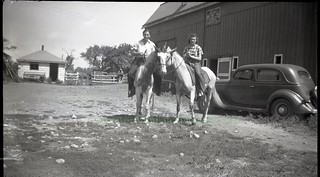
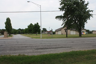
Hobart Then and Now: Bracken Riding Stable

Circa 1940, and 2016.

2016-7-29. st099
2016-7-29. sort of approximately in the vicinity of the Bracken stable
(Click on images to enlarge)
Top image courtesy of Eldon Harms.


The 2016 photo is vaguely approximate. Don't start telling people that the Barrington Ridge Baptist church is on the site of the old Bracken riding stable. Of course I asked Eldon Harms when we were looking at this photo, but he could not remember the exact location of the stable — only that it was along S.R. 51, north of where the CVS store is now.

And my guess at circa 1940 is very approximate, too. The car in the photo, Eldon told me, is a 1935 Ford, so the date must be 1935 or later; something about the (unidentified) woman's hair says "World War II" to me, but that's just a vague impression.

The sign above the stable door reads:

BRACKEN
INDIAN RIDGE STABLES
SADDLE HORSES FOR HIRE
BY THE HOUR
INSTRUCTION IF DESIRED


Eldon remembered the Bracken riding trail as going along 14th Street … or maybe going before 14th Street.

Wednesday, July 27, 2016

For Sale or Rent: Mysterious Places

Two items from the "All kinds of Wants" column in the Hobart Gazette of Sept. 8, 1922:
FOR RENT — My farm of 100 acres, on Lincoln Highway, south of Ainsworth. Julius Triebess, 6936 Michigan avenue, Chicago.
FOR SALE — My house, barn and acre tract at Fatout, south of old Deepriver schoolhouse, on C.&I. railroad. Otis Guernsey, Route 2, Crown Point.
I've been unsure about who, if anyone, has been renting the Triebess farm; I hope one of the papers will report on its new tenant.

That second item has taken up 'way more of my time than it should have. We know that Otis Guernsey's farm lay northeast of where Randolph Street crosses the C&O Railroad. When Harold Guernsey died in 1921, his obituary used the name "Putout" — which I believe to be a simple typographical error, since my notes from 1916 carry the first mention of "Fatout":
Delbert Young has moved into the new house which he has built on the road leading south of the Deepriver schoolhouse past "Fatout," the new railroad station. His new house and barn look fine.*
And now in 1922 we see it spelled "Fatout" again. Majority wins. But Google, which knows about everything, doesn't know about the village or railroad station called Fatout.**

And what about the railroad where Otis' property lay? Is "C.&I." a typo for "C.&O."? The C&O railroad has had several names, but I can't confirm that "C.&I." was among them. There was a railroad in Pennsylvania with those initials, which I didn't want to know but had to spend the time finding out because of this stupid little want ad. Is it any wonder I can't get anything done?

Well, if you want my theory on all this, here it is: the C&O Railroad built a new station circa 1916, probably about where Randolph crosses the tracks, called it Fatout after one of its bigwigs, but — in contrast to how thoroughly the station name "Ainsworth" was adopted — the name never really took hold among the locals and was forgotten until I came along nosing around in the old microfilm.

♦    ♦    ♦

Another mystifying item from the "Local Drifts" of the Hobart Gazette of Sept. 1, 1922:
H.F. Carey, who recently moved upon his farm, has rented his house and five acres south of 10th street to Mr. and Mrs. Wm. Bracken, who have leased the place for 14 months, and moved yesterday.
I don't know where the Carey house was. I used to think it was one of the older ones on the north side of 10th but according to this news item it was the south side. Or was just the five acres on the south side?

The item goes on to say that Mr. and Mrs. Howard Bracken would continue to occupy the Bracken place, moving into the big house from the small house. I gather that Mr. and Mrs. William Bracken are the parents of Howard. William was born on that farm and when he married, he and his wife took up housekeeping there, so this was the first time he'd ever lived off the old Bracken place. But the Bracken milk route — William's, I'm assuming, though it's not clear — would continue without interruption.
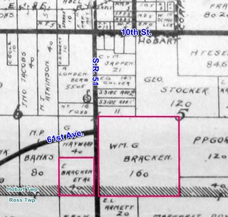
2016-7-27. Bracken 1908
(Click on image to enlarge)
Bracken land as shown on the 1908 Plat Map. The 1926 Plat Book shows the parcel on the west side of S.R. 51 belonging to someone else.


_______________
*"Additional Local News," Hobart Gazette 30 June 1916.
**It doesn't help that there was a Purdue U. professor named Paul Fatout who wrote about historical topics and whose name clogs up the Google searches.

Monday, July 13, 2015

The Lye Accident, and an Update

I was nosing around in old issues of the Hobart Gazette, looking for any mention of Daisy Chester's marriage to E.D. Scroggins that I might have missed the first time around, when I came across this item in the January 4, 1907 issue that I definitely missed the first time around:
A week ago last Sunday the 2-year-old son of Mr. and Mrs. Chas. Chester who live on the Dick Sykes farm pulled from a table a can of concentrated lye which flew upon the little fellow's face and severely burnt him. The right eye seemed to be the worst for the accident and for several days it was feared he would lose its sight but it is now thought the eye will be all right in time.
Based on the 1910 Census, I conclude that the unnamed two-year-old was Robert Chester.

I do not know where the Dick Sykes farm was. Per the 1891 Plat Book, there had been farms belonging to Sykeses in Ross, Hobart and Winfield Townships — not to mention any that may have been in Porter County — but which was known as the "Dick Sykes farm," I do not know.

[7/20/2015 update] Suzi Emig has solved the mystery of the Dick Sykes farm! She writes:
Climb into the time machine ... we are going back to April of 1912. I have attached the newspaper account of my dad's parent's wedding. It was extremely yellowed and fragile when I got it years ago from my aunt. Fortunately she laminated it, so it survives. You will see many familiar names in the list of wedding guests. There is one error. The bride's mother, Mrs. Susan Casey, was a sister to Constance Chester, not to Mr. as stated. If you refer to the 1908 plat map (which you so conveniently provide!) the SE corner of 61st and Colorado is owned by a William Sykes ... maybe Dick was a nickname or he was incorrectly named in the lye incident article. William is shown in the 1880 census to be living on this property as a 21 year old with his mother and siblings, 3 brothers and a sister. Their neighbors are the John Schnabels. Their main house was on the SW corner of the intersection. It appears that William and his family were living here per the 1900 census, as the Fred Schnabels are listed as neighbors. Evidently William decided to give up farming and leased his home and land ... he is in Mississippi, working as a public road contractor in 1910, then in 1920 is back up north residing in Gary as a city clerk, and a garage owner there in 1930. He died in 1940 in CA. My dad always referred to that SE property as "the old Sykes farm", so I guess to the old timers that name stuck. The Charles Chesters were living in Stark Co., IN per the 1900 census. In 1910 they were somewhere in Ross Twp., and evidently relocated by 1912 to the Sykes property. By 1920 they were in the old house that Henry built.
2015-7-20. Schnabel Casey
(Click on image to enlarge)
I believe this clipping is from the Hobart Gazette of April 19, 1912.


Here is the William "Dick" Sykes farm on the 1908 Plat Map:

2015-7-20. Sykes 1908
(Click on image to enlarge)

Here's a clipping from the "General News Items" of the Hobart Gazette of July 5, 1907 (I didn't miss it the first time around; I just didn't post it) in which "Dick" is enclosed in quotes, as if to mark that it is a nickname.

2015-7-20. Chester-Sykes, Gaz, 7-5-1907

Here ends this update. If I find out how William got his nickname, I will update again.

♦    ♦    ♦

Thanks to our identifying-est commenter ever, we now have IDs on the people in the Chester-house-then-and-now pictures. (I have also added Chuck's IDs to each picture's description on Flickr, for ease of reference.)

Sunday, March 10, 2013

From the Crime Files:
The Case of the Roving Ruminant

Ensign cow crime
(Click on images to enlarge)

In the annals of unsolved crime, it's hardly enough for a footnote, but this story gives me the impetus to look into the Ensign family, whom up until now I have mentioned only in passing.

I believe "Mrs. Ensign" in the story would be Elizabeth Ensign, listed in the 1920 census as a divorcée of 62 (the 1910 census described her as widowed). She apparently lived near her son, John, who was married with several children. I think John may be the "J.E." marked on a small parcel in a 1926 plat map:

Ensign 1926

… in which case the cow did not have far to wander to end up in William Bracken's field.

John Ensign describes himself in 1920 as both a farmer and a telegraph operator (with the E.J. & E. R.R., per his draft card). Elizabeth also had a younger son, Walter. I don't know whether she had any other children because this family is proving elusive as we go further back in time.

♦    ♦    ♦

Above the cow story you will note the story about the progress of paving Hobart … or lack of progress, at least temporarily. I don't know how the strike was "adjusted." The Gazette, published a day later, serenely ignored the strike, and a week later reported:
The Powers-Thompson Co. has finished paving 6th street, and Wednesday morning commenced work on Indiana street, at Cleveland avenue. It is probable that South Main street and Garfield will not be done until quite late this summer.

Sources:
♦ 1910 Census.
♦ 1920 Census.
♦ 1926 Plat Book.
♦ "Local and Personal." Hobart News 10 June 1920.
♦ "Local Drifts." Hobart Gazette 11 June 1920; 18 June 1920.
♦ WWI Draft Cards.

Saturday, March 24, 2012

Lights on the Ainsworth Road

One of the matters up for discussion at Hobart's town board meeting on March 10, 1919, was a petition from residents along the Ainsworth road, i.e., State Road 51 between Hobart and Ainsworth. The petition was signed, according to the News, by "S.R. Collver, Chas. Sapper, Dave Vinegar, Harvey Auton, David Cox, M.H. Smith, H.W. Bracken, W.G. Bracken, J.C. Kellen, Jos. Hudson, H.L. Ryan, Robert Reichert, V. Miscevich, Mike Drakulich, and George Hayward." They were asking for four electric lights to be installed on the part of the Ainsworth road described as lying "between the Sapper corner and the Peddicord farm." I suppose the Sapper corner is about where S.R. 51 turns south from 10th Street. The 1926 Plat Book doesn't show enough detail in that area to be helpful, so let us turn to the 1939 Plat Book, in which some holdings may have grown, shrunk or changed hands, but we can see some names that correspond to the 1919 report.

From Sapper to Peddicord 1939
(Click on image to enlarge)
This excerpt from the 1939 Plat Book shows, at the top, 10th Street intersecting with Lake Park Avenue, aka S.R. 51, formerly known as the Ainsworth road.


The town board accepted the petition and instructed the superintendent of Hobart's power plant, Robert Wheaton, to draw up an estimate of the project's cost.

He did so within two weeks, and at the March 24 meeting, the town board faced the question whether they ought to spend $76.32 on lights for the Ainsworth road. After due consideration, they ordered that the lights be installed.


Sources:
♦ "Town Board Doings." Hobart Gazette 14 Mar. 1919; 28 Mar. 1919.
♦ "Town Board Doings." Hobart News 13 Mar. 1919.