Showing posts with label C&O RR. Show all posts

Sunday, September 20, 2026

Stoltz Family Stories: The Tragedy

While searching in the online newspapers for any explanation of 1911 plate from the John Stoltz store of Merrillville, I came across a story of a 1914 tragedy that devastated another branch of the Stoltz family.

It's odd that I was shocked to find that story. I must have seen it before: it was reported on by both of the Hobart newspapers, which I had read on microfilm long ago. Not only did I neglect the story the first time, I forgot I that my eyes had ever swept over it. The fallibility of human memory is a topic that comes up sometimes in this blog, and I have to say that my own memory heads the list of the fallible.

But let us proceed.

Among John Stoltz's many siblings was an older brother, Joseph, born in Illinois (like John) in 1868. By the time we catch up with Joseph in the 1880 Census, with the family living in Hammond, he was 12 years old and already gainfully employed. In what capacity, the census doesn't say; I hope he wasn't working in the slaughterhouse with his father.

In February 1891, Joseph married Mary Diedrich, and the young couple quickly started a family. In the 1900 Census, they were the parents of five children, four of whom were still living. Joseph described himself as an "express man." Trying to find out exactly what that meant took me on a side trek and I'm still not sure exactly what his job entailed. But evidently it didn't pay a great deal, as the household included two boarders.

Joseph and Mary lived more quietly than his brother John, so I'm not sure when they moved their family from Hammond to rural Ross Township. But that is where we find them in the 1910 Census. They were farmers, not storekeepers. Their rented farm appears to have been south of Merrillville (to judge by those of their neighbors who were not also renting). The household included seven children: Daniel (15), Cora (13), Margaret (9), Philomena (6), Fredrick (4), and Theresa (1); their oldest daughter, 17-year-old Katherine, is not listed with them (which may be a mistake by the enumerator).

A couple years after the census, Joseph's mother, Elizabeth — widowed in 1899 — came to live with them.

On October 2, 1914, tragedy struck the family.
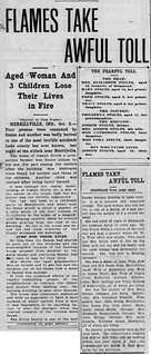
2026-09-20. 1914-10-03. Flames Take Awful Toll, Lake County Times (Hammond, Ind.), 3 Oct. 1914
(Click on image to enlarge)
Lake County Times (Hammond, Ind.), 3 Oct. 1914.


The reference to "Tracy Stoltz, aged 6," is to little Theresa, who was one year old in the 1910 census.

Two days later, the Times reported on the funerals and burials of the victims.

2026-09-20. 1914-10-05. Bury All in One Coffin, Lake County Times p. 1
(Click on image to enlarge)
Lake County Times (Hammond, Ind.), 5 Oct. 1914.


Besides adding some heart-rending details, the article mentions a "passing Chicago autoist." Some days later, he and his wife, who also helped, were identified:

2026-09-20. 1914-10-15 Jess Nichols Proves Himself to Be Real Hero, North Judson News, p. 1
(Click on image to enlarge)
North Judson News, 15 Oct. 1914.


As mentioned in the October 5 article, all the children were buried in SS. Peter and Paul Cemetery. Their entry on FindAGrave does not include a photo of a grave marker; nor does NWIGS' Ross Township Cemeteries note their grave in its listing, so it may be unmarked.

The grandmother, Elizabeth Weis Stoltz, is buried in Hammond.

♦    ♦    ♦

The exact location of the Stoltz farmhouse is unclear. The family was probably still on rented land. One of the newspaper articles describes the house as "about a quarter of a mile south of the four corners in Merrillville" — the "four corners" being the intersection of 73rd and Madison. That would translate to a bit south of the intersection of 75th and Madison, which means Section 16, or Section 21 if the article's writer underestimated the distance south from the "four corners."

If we look at the 1908 Plat Map, we find some interesting names on the east side of Madison in Section 16, and just below its southern boundary:

2026-09-20. Section 16, Twp. 35 N and surrounding, 1908
(Click on image to enlarge)

Andrew Popp was Elizabeth Weis Stoltz's brother-in-law. And her own brother, John Weis, was among the "et al." in the "Elizabeth Weis et al." who owned 120 acres south of the Popp land. (John and Elizabeth Weis were the parents of Michael, whom we met in my previous post as the manager of the Marion Pierce store that preceded the Stoltz store.) It seems likely to me that the Stoltz family would rent land from relatives. However, according to A Pictorial History of Merrillville, both the Popp home and the Weis home were (and still are) the original structures — there is no mention of either burning in 1914.[1] There may have been another house on the land, or the Stoltzes may have rented on the west side of Madison. In short, I don't know the location of the farmhouse that burned.

Nor do I know where the surviving family lived after the loss of their rented home. The 1920 Census shows them living in their own home in Merrillville. It was probably a home in town, or close to town with a much smaller lot, as the 1926 Plat Book doesn't show any parcel belonging to them. Joseph was no longer farming; he had gotten work in the steel mills. The family was again taking in boarders.

♦    ♦    ♦

At the Merrillville History Museum is a three-ring binder full of notes that we believe were gathered through interviews conducted by Jan Clemens (and any helpers she may have had) in the mid-1970s in preparation for writing A Pictorial History of Merrillville. The 1914 Stoltz tragedy is not mentioned in A Pictorial History, but it is mentioned in the notes in the three-ring binder, along with another tragedy in the family.

2026-09-20. p. 200 Geneology Notes 1970s
(Click on images to enlarge)
Images courtesy of the Merrillville-Ross Township Historical Society.


2026-09-20. p. 201 Geneology Notes 1970s-201

2026-09-20. p. 202 Geneology Notes 1970s-202

I think there were two interviewees, one of whom comes in on the third page with only a few lines. The first interviewee, covering the first two pages plus the top of the third, is surprisingly familiar with the tragedy some 60 years after it happened, naming all the young victims of the fire.

There is one odd detail in the story — the house that burned is described as "the old cheese factory." Now, among the people who run the Merrillville-Ross Township Historical Society, the old cheese factory in Merrillville is thought to be still standing at 7200 Madison Street. According to A Pictorial History, that house/cheese factory was built in 1880 to replace an earlier cheese factory on Walter Avenue. (The county records give it a build date of 1900, which is often a way of saying, "We don't know the exact year, but it was a long time ago.") The only other cheese factory mentioned in A Pictorial History was one built in 1855 by Dudley Merrill along 73rd Avenue — that one was donated to the Methodist Church's Ladies Aid Society by Charles Merrill (1850-1913).

So, was the interviewee confused, or was there yet another cheese factory south of Merrillville that has been lost to memory?

The second interviewee has only a few remarks on the tragedy: "Grandmother [Mary Diedrich Stoltz?] had to jump out the window; broke both ear drums — stone deaf. Spark from train set house on fire." Although the Times article of October 5, 1914, describes the house as one story high, I suppose a fall from a first-story window could rupture eardrums. The detail about the fire's originating with a spark from a train is more confusing — there were no train tracks between 73rd and (present-day) U.S. 30, so if the newspapers were correct about the Stoltz house being south of Merrillville, this detail could not be true. The "old cheese factory" house was close to train tracks, but it (so far as we know) never burned.

Could the second interviewee's memory have been shaded somehow by that other family tragedy mentioned on the first page of notes — Mary Stoltz's death on the C&O train tracks?

2026-09-20. 1943-09-24 Deaf Woman Hit, Killed by Train, Hammond Times
(Click on image to enlarge)
Hammond Times, 24 Sept. 1943.


It's interesting how this event is retold by the first interviewee in the 1970s notes:
Mary … was killed by a train while walking from Walter Demmon's grocery store. She used to walk on the railroad track to the store…..they had a path worn from their house to the store…..she had thought about stopping to visit next to the store but changed her mind and decided to take the short-cut home.
How on earth could anyone have known what she was thinking in those last minutes before she was killed?


It is just possible, of course, that the odd details in these retellings resulted from confusion on the part of the note-taker!


_______________
[1] Per the county assessor's records, both the Popp home (7489 Madison), and what I believe to be the Weis home (7883 Madison) were built in 1870. Build dates in the 19th century are often approximations. Incidentally, A Pictorial History does not give an address for the Weis home, but says that it is south of U.S. 30; I believe this to be an error. No plat map shows John and Elizabeth Weis owning any land south of what is now U.S. 30.

Friday, November 19, 2021

The Farm Under the Big Boxes

Standing at the intersection of U.S. 30 and Colorado street today and looking west, you see a vast expanse of asphalt surrounding big-box stores such as Sam's Club, Wal-Mart, and Home Depot, as well as restaurants and gas stations. Thousands of vehicles pass through the intersection, day and night. The parking lots are never empty. The lights never go out.

You can hardly imagine those hundred-plus acres as quiet farmland. You can hardly imagine U.S. 30 ending there, either; and yet all the maps we have show the road that is now U.S. 30 going no further east than Colorado, until the new Lincoln Highway came through in the mid-1930s.

I have been researching that area because the Merrillville-Ross Township Historical Society received an inquiry about the farm that once lay there — specifically, the farm of Frank and Catherine Willy, which comprised approximately 115 acres on the west side of Colorado Street, cut in half by the road that is now U.S. 30.

Here is my attempt to outline the Willy farm on the modern-day Google satellite view:

2021-11-19. Willy farm outlines, 2021 satellite view
(Click on image to enlarge)
Image from Google.com.


This farm, under various owners, had retained nearly the same dimensions for over a century. The earliest record I can find of it comes from the NWIGS' Early Land Sales, Lake County: on October 18, 1852, Harmon Underwood bought a total of 160 acres.[1] On January 11, 1854, those 160 acres became the property of John Underwood, who I believe was Harmon's son.[2]

Sometime between 1854 and circa 1874, the farm lost 40 acres on the west, as we can see on the 1874 Plat Map:

2021-11-19. 1874 Ross Twp. - future Willy farm
(Click on image to enlarge)

The new owner of those 40 acres, P.A. Banks, was probably Parley A. Banks. You can also see that H[armon?] Underwood owned another 200 acres east of the original farm.

And lastly, you can see that the mapmaker has clearly drawn a road from the west up to what is now Colorado Street, but eastward of that point, there is no trace of a road.

The 1891 Plat book does not include Section 23, so next we have to jump forward to 1908. Now we find the farm owned by Mary Burge.

2021-11-19. 1908 Ross Twp. - future Willy farm
(Click on image to enlarge)

We also find the parcel reduced in size by almost five acres, taken, I believe, by the Chicago, Cincinnati & Louisville (later Chesapeake & Ohio) Railroad, which began buying up right-of-way through Ross Township circa 1903.

My best guess as to the identity of Mary Burge is that she was a daughter of Julius and Nancy Demmon and married Winfield Scott Burge in 1878. The 1900 Census shows Winfield and Mary, with numerous children, living on their own farm in Ross Township in the general area of Colorado and U.S. 30 (to judge by their neighbors). Mary died in 1922. By the mid-1920s the farm had been sold: we find a new owner in the 1926 Plat Book.

2021-11-19. 1926 Ross Twp - future Willy farm
(Click on image to enlarge)

I cannot identify Caroline Schwer.

In 1932 the farm changed hands again. I will let the new owner tell the story of how that came about, as he told it to his descendants:
Three Ears of Corn

by Frank Anthony Willy

After Frank and Catherine were married, they moved onto a farm in Dyer, Indiana, which Frank rented from his father August. Besides charging rent, August required his son to hire his brothers to work the farm. This was a difficult situation at best for Frank and Catherine. During the Depression they had little money to spend and Frank's brothers were teenagers, with poor work ethics. Eventually Frank and Catherine realized that they could no longer afford to rent the farm in Dyer. They knew they would have to go out on their own and start a new life away from Frank's family.

Frank set out to visit three farms that were for sale nearby. The first was in Wisconsin. The ears of corn in the fields were large and well-formed and the house was well built with a natural spring underneath that could be used to keep food cold. This farm, he thought, would be an excellent choice.

The second farm he visited was in Illinois. Once again, the corn in the field was large, showing that the soil had been well taken care of. The outbuildings and home were also in excellent shape. He believed this would be a good farm to own.

Lastly, Frank visited a farm for sale in Indiana. This corn was just "nubbin."[3] The soil seemed to be spent, with most of the nutrients used long ago. The farm and its buildings were neglected and in very poor shape. As he took pictures of this farm he thought, "This is a very poor farm. It would be difficult to make a go of it here." As Frank returned to Catherine to tell her of his trip, his heart was heavy. He laid an ear of corn from each farm in front of her and then began to cry, for he knew the only farm they could afford was the neglected one in Indiana. And so it came to pass, that in 1932, Frank and Catherine Willy moved their family of eight and all they owned to the neglected Indiana farm with "nubbin" corn. Little did either of them realize what an excellent choice it would turn out to be.
(Story courtesy of Nick Hopman.)

Frank was then about 35 years old, Catherine (née Alber) about 32. They had been married in 1920.

Frank mentions taking photos of the farm when he first visited it. That may be the source of these two photos of the farmhouse and barn.

2021-11-19. 1932 Farmhouse in country
(Click on images to enlarge)
This and the following image courtesy of Nick Hopman.


2021-11-19. 1932 Farm in Crown Point 1932

Again, thanks to Nick Hopman, we have Frank Willy's own story about the early days on the farm, and what the construction of the new Lincoln Highway did for the family:
You kids first went to St. Peter and Paul's School. I had to drive you. But when I had no money to buy gas, I sent you to the Ainsworth school as the bus passed our house. The first day you came home you said you needed about $14.60 for books. Had to sell corn for $.12 a bushel. Had about $.60 over on that truckload. That shows you what the Great Depression was like. I did not sell any more, as Henry Bloom[4] said, "Don’t sell. I will go along with you if it takes ten years. I won't foreclose on the mortgage!" The mortgage was for $7,000. The next year we had the cinch bugs. Twenty acres of corn barely filled my little silo. The next year we had the great dust storm. Steady wind from the southwest. In Kansas the dust covered fences and buildings. People left their farms. We bit our lips and held on.

Had 12 acres of fine wheat. Wanted to cut it on Monday. Henry Bloom was out on Saturday. "You ought to cut it. Sometimes it don't pay to wait 'til it has fully ripe." Sunday night it hailed. Shocked everything flat. Holes in the tarpaper roofs. Cut off branches of trees. It was a quarter-inch thick on the ground. I raked the wheat field and got Hank Homeier[5] to come and thrash it. Blew the straw into the barn and got 60 bushels of wheat. I needed that straw. Also paid Koehler[6] $10 so I could cut some slough grass, and Old Nick (our hired hand) herded the cattle there. In 1934 the new highway (US 30-the Lincoln Highway) came through. Then I had it made. When US 30 road work was being done I rented a small area to the state for material storage. When the work was done, instead of having the state clean up the storage area by removing the remaining sand, gravel, and steel, I negotiated to do it myself, for a price of course. But instead of cleaning up the mess, I just sold the materials until they were gone.
For some reason, the 1939 Plat Book fails to show the new highway east of Colorado:

2021-11-19. 1939 Ross Twp - Willy farm
(Click on image to enlarge)

But the 1939 aerial view shows it clearly:

2021-11-19. Aerial photo 1939 Willy Farm (LakeBFJ-04-043)
(Click on image to enlarge)
Image from https://igws.indiana.edu/IHAPI/Map/.


This raises the question whether the 1874 cartographer just made a mistake about the road extending east of Colorado, and that mistake was perpetuated by subsequent map-makers who didn't bother to investigate for themselves. But I am going to ignore that possibility because it's just no fun at all.

Anyway, the 1950 Plat Book shows the new U.S. 30:

2021-11-19. 1950 Ross Twp. - Willy farm
(Click on image to enlarge)


As you can see from the 1939 aerial view above, the Willys' house and farm buildings stood on the west side of Colorado Street, north of U.S. 30. This photograph shows more clearly how the buildings were arranged in relation to Colorado Street, which runs diagonally across the bottom of the photo:

2021-11-19. Willy farm, Crown Point mail address
Image courtesy of Nick Hopman.


Frank and Catherine Willy farmed that land for 30 years, through the Great Depression, through World War II, and beyond. Their children grew up, moved out, started families of their own. Frank and Catherine bought a modern ranch house in the Green Acres neighborhood. In 1962, they sold their farm.

Here is the former Willy farm as it appears in the 1972 Plat Book:

2021-11-19. 1972 Ross Twp. - former Willy farm
(Click on image to enlarge)

The new owner probably rented most of the land to locals who were still in the farming business.

This 1978 aerial view from the Lake County GIS website shows that the farmhouse and outbuildings have been removed, and some kind of business is operating in the northwest corner of the U.S. 30/Colorado intersection:

2021-11-19. 1978 aerial view (Lake County IN GIS)
(Click on image to enlarge)

The 1990s brought the era of the big-box store, and the landscape of the old farm was utterly transformed.


_______________
[1] He bought the south half of the northeast quarter, and the north half of the southeast quarter.
[2] Cf. Lake County Encyclopedia, p. 80. I'm a bit confused.
[3] "Nubbin" — a small or imperfect ear of corn [per the author].
[4] We don't know for certain who Henry Bloom was. My best guess is Henry Blume (1867-1958), who shows up in the 1910 Census farming his own land in Center Township, but in all subsequent censuses he gives no occupation. He and his wife, Mary, had only one child, who died in 1920.
[5] I think this was Henry Homeier, who farmed northeast of Merrillville.
[6] I give up.


Sunday, October 16, 2016

Steam Engine Running Beside a Plowed Field

Here's another entry in my series, "Not Ainsworth But Could Be."

When I first saw this photo, I thought: That's how the Grand Trunk steam engines must have looked running past my field, back when Henry Chester farmed it!

2016-10-16. Grand Trunk steam engine
(Click on images to enlarge)

Unfortunately, the notes on the back give Grand Haven, Michigan as the location and 1947 as the year …

2016-10-16. Grand Trunk steam engine verso

… so I was way off as to place and time. But still — let exactitude fall to the side, let our eyelids droop, and that's a westbound Grand Trunk train slowing down for the Ainsworth depot.


The first car behind the tender belongs to the Pennsylvania Railroad, the third one to the C&O Railroad — both lines that would have been a part of life in Ainsworth, though not quite as large a part as the Grand Trunk Railroad.

Sunday, December 20, 2015

Caught in a Speed Trap

After passing through the "Christian utopia" of Zion City, Illinois, on June 9, 1922, Charles Chester and John C. Cavender had nothing good to say about its justice system or its roads.

2015-12-20. Speed trap in Zion, Illinois
(Click on image to enlarge)
Hobart News 15 June 1922.


(You will notice in the left-hand columns of the page above the news of William Devonshire's death. A childless widower, he left everything he had to the Masons.)

The Gazette's telling of the speed-trap story did not turn out quite so well for Charles:

2015-12-20. Speed trap in Zion, Illinois
(Click on image to enlarge)
Hobart Gazette 16 June 1922.


Over in the "Local Drifts" columns, we are reminded that in Hobart, at least, thievery is done in the dark of night rather than the light of day — and not nearly so methodically; and that in Merrillville, work is going forward to keep "dead man's crossing" from claiming any more victims.


Additional Source: "Oldest Mason Dies in Hobart." Hobart Gazette 16 June 1922.

Thursday, October 15, 2015

"Dead Man's Crossing" and School Plumbing

2015-10-15.
(Click on image to enlarge)
Hobart Gazette 19 May 1922.


We've already read of one particularly horrific accident at the Merrillville C&O crossing; that may have been enough, or perhaps there were others, to inspire the "dead man's crossing" nickname.

The description of the new school building about to go up in Wheeler and be plumbed by Lee & Rhodes sounds like the one still standing at Fifth and North (but no longer a school):


I don't know where the "present building at Union Center" was in 1922 — possibly in the vicinity of present-day Union Center Elementary School, but that's just a guess.

Lee & Rhodes were also installing new toilets in the Nickel Plate depot, the old ones having been condemned, along with "a number of other toilets about the city," several weeks earlier by the secretary of Hobart's board of health.


Additional Sources:
♦ "City Council Doings." Hobart Gazette 5 May 1922.
♦ "Local and Personal." Hobart News 18 May 1922.
♦ "Local Drifts." Hobart Gazette 19 May 1922.

Saturday, May 31, 2014

Merrillville From the Air, 1939

Here we have two aerial photos of Merrillville from 1939.

2014-5-31 BFJ-03-086
(Click on images to enlarge)
Images courtesy of the Indiana Geological Survey, I.U. Bloomington.


2014-5-31 BFJ-03-087

I got these thinking they would clarify the location of the railroad depot, but I was wrong. There are two rectangles in that vicinity and we're not sure which is the depot.

Tuesday, May 20, 2014

Merrillville Then and Now: C.C. & L.R.R. Depot

Circa 1909, and 2014.

5-20-2014 CCLRR depot by Haase
5-20-2014 CCLRR depot site 2014
(Click on images to enlarge)

Not exactly illuminating, is it? The former railroad is now a bike path, and all traces of the depot are gone.

Someone tried to explain its location to me as we looked out the front window of the Merrillville/Ross Township Historical Society Museum on 73rd, just west of Broadway. "It was behind that second evergreen," she said.

5-20-2014 Second evergreen

Let's hope those evergreens never get cut down.

The postcard is postmarked Dec. 1909, meaning that the depot had but a short time to bear the name of the Chicago, Cincinnati & Louisville Railroad. By July 1910 it would be the Chesapeake & Ohio RR depot.


Here's the verso:

5-20-2014 CCLRR Depot verso

I believe the sender was 19-year-old Hattie Nasshahn McCarty, writing to her brother, Emil (about 22 years old). The Nasshahn family lived in Merrillville — from when, I'm not sure, as I can't find records of them earlier than 1900, but an infant sister, Lydia, who died in 1885, is buried in Merrillville Cemetery, as is their father, Emil Sr. (d. 1891), their mother, Elizabeth (d. 1911), and another sister who died in childhood.

The family earned a mentioned in A Pictorial History of Merrillville, which states that the widowed Elizabeth and her children ran a grocery out of their own home, "located on West 73rd Avenue across from the old Iddings house and adjacent to the Perry Goodrich home."

In 1908 Hattie married Frank McCarty, a railroad telegraph operator — I do wonder if he is one of the men pictured on the postcard! Sometime between 1910 and 1920, the McCarty family moved to Noble County, Indiana, where Frank and Hattie lived out the rest of their lives. As for Emil, he lived, married, fathered, and died in Oregon.


Sources:
♦ 1900 Census.
♦ 1910 Census.
♦ 1920 Census.
♦ Clemens, Jan, and Merrillville/Ross Twp. Historical Society. A Pictorial History of Merrillville. 1976, updated 1991.
♦ Indiana Marriage Collection.
♦ Northwest Indiana Genealogical Society. Ross Township Cemeteries. 1995.