Showing posts with label Ewing. Show all posts

Thursday, March 21, 2024

Lovers Lane (a/k/a Beer Can Lane)

If you were a young person living in Ainsworth or Hobart in 1963 who wanted to go somewhere to neck and/or drink beer, where would you go? Here's an idea:

2024-03-21. Boy Shot In Lovers Lane Fray, Gazette, 25 July 1963
(Click on image to enlarge)
Gazette, 25 July 1963.


From the description, Baier Road must have been what is now known as East 61st Avenue:[1] it's the only road that connects County "K" and County Line Road — that is to say, the only such road that isn't Tenth Street, and if it had been Tenth Street, the article would have said so, and would not have said the road was "approximately even with 14th St."

Even now, in spite of the increase in population and traffic around here in recent decades, that stretch of road seems isolated and sparsely traveled.

Here is a 1962 directory listing of the shooter:
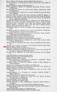
2024-03-21. 1962 directory listing
(Click on image to enlarge)
Polk's Hobart City Directory 1962. R.L. Polk & Co.


I would never have known where Baier Road was if not for this newspaper article. But how did it get to be called Baier Road? I have been accustomed to seeing roads named after a substantial farmer on them — e.g., the Chester road (Ainsworth Rd.), the Springman road (Randolph St.) — or a destination they are used to travel to — e.g., the Ainsworth road (Grand Blvd., S.R. 51), the Palmer road (Randolph St. south of the Lincoln Highway). So let's take a look at Baier Road in the 1950 Plat Book:
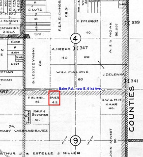
2024-03-21. Ross Twp. - East
(Click on image to enlarge)

As you can see, the Baiers owned only 4.5 acres according to this plat map, and my earlier and later plat maps don't show them owning any more than that.[2] How did this road avoid being called after the Leszczynskis, or the Malones, or the Zelenkas or Kaars or Blimels?

I suspect the answer might lie in Mr. Baier's job. Peter and Helen Baier first show up in this location on the 1930 Census as a young married couple, with Peter describing himself as a "poultry man," but by the 1940 Census he had become a foreman with the State Highway Department. I wonder if somehow he did some work on that road — although it was not a state road — and thus got it connected with his name? By the 1950 Census Peter was a "General Sup" (supervisor, I'm guessing) in "Home Construction." The three houses now standing on or near the Baier property all date to the 1950s; is it possible that Peter was involved in building them?

One way or another, it seems he was a fairly prominent person in that area, despite his 4.5 acres.

The 1962 Polk's directory lists him on "RD 2" but doesn't add "Baier rd." as in the Ewing listing above.

Speaking of Mr. Ewing, here's an article from the Hammond Times of July 23, 1963, that gives a little more information about him:

2024-03-21. Hammond-Times-July,23-1963-p-17
(Click on image to enlarge)
I haven't found any follow-up articles about what, if any, penalty was imposed on him.


In the 1962 directory page posted above, the listing directly above Robert's shows his parents, Lee and Anna. Robert had gotten married in 1955 (Indiana Marriage Collection); the marriage produced several children. Robert and his wife, Beverly, appear in my 1991 directory living on 8th Street in Hobart. Robert died in 2007.

The young man who was shot, Jeffrey Johnson, must have recovered, as he went on to lead a full life, and died of natural causes in 2018.

Peter Baier had died in 1987. I wonder when his road lost his name?

_______________
[1] The county assessor's records still use "Baier Rd." in the site addresses for properties on that road, although their mailing addresses use "E. 61st Ave."
[2] One interesting thing I've noticed on many of my plat maps, from 1874 to 1972, is that they seem to show South Union Street running through from Tenth Street all the way to Baier Road. Today there is no trace of any connection: Union St. comes to a dead end well north of E. 61st. But in the 1939 aerial photos, S. Union, while narrow in comparison to the other roads around it, does appear to run all the way south to E. 61st. In the 1973 aerial photos, I can't see a connection between S. Union and E. 61st.

Wednesday, September 1, 2021

"A Decent, Sober Indian Woman"

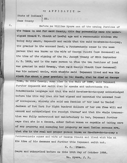
While looking through some land title abstracts at the Merrillville/Ross Township Historical Society, I came across this strange document:

2021-09-01 land009
(Click on image to enlarge)
Image courtesy of the Merrillville/Ross Township Historical Society.


What struck me was Edward Cicott's description of his aunt-by-marriage: "a decent, sober Indian woman as capable to taking care of any property and managing her property as most Indian persons are." In all of the title documents I've looked at, I have never encountered any such characterization. The affidavits I've seen have dealt with factual matters: "I know So-and-so to be who he says he is," or "I was well acquainted with Such-and-such and she died five years ago."

I suppose the Indian Affairs Bureau wanted this affidavit to ensure (or to give the appearance of ensuring) that Me-shaw-ke-to-quay was not being taken advantage of in the sale of her land.

The land she was selling was Section 36, Township 36 North, Range 8 West of the Second Principal Meridian:

2021-09-01 Section 36, Hobart Township
(Click on image to enlarge)
Image from 1939 Plat Book. Don't ask me to explain Clark and Dearborn Streets.


I have marked the Hoffman eight acres at the section's southern edge because the abstract in question came to us through the purchase of that land in 1924.

Earlier in the abstract is a statement that Me-shaw-ke-to-quay held formal title to the land through a treaty made in 1828:

2021-09-01 land005
(Click on image to enlarge)
Image courtesy of the Merrillville/Ross Township Historical Society.


This may be what is meant by the term "floating claim." Per the treaty, Me-shaw-ke-to-quay was entitled to select two sections of undeveloped land within a certain region. This Section 36 was one of her selections. I don't quite understand the timeline: Me-shaw-ke-to-quay sold the land in 1836, but her selection of it wasn't formally approved in Washington until 1837, if this abstract is correct.

All I know about Me-shaw-ke-to-quay is that she was Potawatomi, and married a white man, George Cicott. He is almost as elusive. A 1913 history of Jefferson Township, Cass County,[1] gives us a little information:
George Cicott was the first white man to set foot within the present boundaries of this township. He was a French-Canadian who for many years lived and traded with the Pottawattomie Indians and married an Indian wife.

The Indians looked upon him as one of their number and he was, so far as the rights and privileges of the tribe were concerned. By the treaty of 1826 a reservation of over one thousand acres in the southern part of the township was ceded to him, as were also other tracts of land, including the present site of Logansport. From the sale of these lands he accumulated quite a fortune. Immediately after the cession of these lands in 1826, or possibly 1827, Mr. Cicott settled on his reservation as what was afterwards known as Georgetown, and opened a trading post and dealt almost exclusively with the Indians, as there were at the time no white settlers in the township. He erected the first mill in the township in 1829 near the present site of Georgetown … Mr. Cicott died about 1833.[2]
George had an older brother, Zachariah, who seems to be a bit better known, and this essay about Zachariah gives some interesting context.

In spite of the "fortune" that George Cicott accumulated for himself, by 1836 his widow was "poor and destitute," according to our title abstract:

2021-09-01 land006
(Click on images to enlarge)
This image, and the images below, courtesy of the Merrillville/Ross Township Historical Society.


2021-09-01 land007

I cannot identify the purchaser, Daniel Jackson.

An interpreter was involved in at least part of the transaction:

2021-09-01 land008

Everyone (except perhaps the buyer) was in Cass County at that time. I have no evidence that Me-shaw-ke-to-quay ever lived on this Section 36.

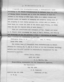
In addition to the affidavit of her nephew with which I began this post, another trader named George W. Ewing certified, in 1838, to Me-shaw-ke-to-quay's competence to conduct the transaction …

2021-09-01 land010

… but based on what I've learned about him, I wouldn't take his word for it. (And I'm not sure Edward V. Cicott was any better.)

George Ewing uses much the same language as Edward Cicott did to describe Me-shaw-ke-to-quay: "sober, decent and prudent." Now, I can understand "sober" and "prudent," but what does "decent" have to do with competence to sell one's land?

_______________
[1] Powell et al. (eds.) History of Cass County, Indiana. Chicago and New York: The Lewis Publishing Company, 1913. Reproduced at https://play.google.com/books/reader?id=exgVAAAAYAAJ&pg=GBS.PA616&hl=en.
[2] Most sources give 1833 or 1832 as the year of George Cicott's death; it's interesting that Edward Cicott gives it as 1830 in his affidavit.