Showing posts with label Banks. Show all posts

Thursday, November 6, 2025

Lysander Castle's Lonely Grave

2025-11-06. Castle, Lysander
(Click on image to enlarge)
Image courtesy of the Hobart Historical Society, Hobart, Indiana.


The stone in this photo marks the lonely grave of Lysander Castle, who died in 1851. This digital scan of the photo is taken from the computer at the Hobart Historical Society museum. The original physical photo does not seem to be in the museum. No information about its source was preserved with the scan.

In the Chester Cemetery section of the NWIGS' Ross Township Cemeteries, we find the following text, quoted (if I understand correctly) by the 1992 readers, who noted: "This information about Lysander Castle was taken from previous records":
Lysander was actually buried by Deep River. This is a single stone of a later period than the death date. It was installed by Kelly and son. Tradition has it that this is on property originally owned by Nathaniel P. Banks. Present day owners are the Truitt family, though this property was formerly owned by John Knotts. The marker is a few feet south of Deep River, which cuts through the property, on a high bank in an area completely covered with scrub bushes and blackberry briars.

Tradition further tells that the river was so completely covered by snow and overflowing that the pall bearers could not cross the river even after a two day wait, so the casket was buried on this spot. We have placed him in this record since there are other Castles buried in Chester Cemetery.
Perhaps the photo above was taken by the writers of the "previous records," whoever they may have been, and whenever they may have hiked out there along the banks of the river to find the stone. (A photo taken in 1992, I expect, would be in color.)

Here is the 1874 Plat Map of Section 7:

2025-11-06. Section 7 Ross 1874
(Click on image to enlarge)

The 40 acres marked "M.A. Castle" were purchased by Lysander in 1849:

2025-11-06. Castle, Lysander - 1849 purchase
(Click on image to enlarge)
Bureau of Land Management, General Land Office Records; Washington D.C., USA; Federal Land Patents, State Volumes, via Ancestry.com. U.S., General Land Office Records, 1776-2015[database on-line]. Provo, UT, USA: Ancestry.com Operations Inc, 2008.


M.A. Castle was Lysander's widow, Maria Amanda (Harvey) Castle, whom he had married in 1837 in St. Joseph County, Indiana (Indiana Marriage Collection), and who had married Samuel Lathrop in 1853.

If the "tradition" quoted in the NWIGS book is correct, Lysander may be buried on the bit of land that Nathaniel Banks owned south of the Deep River and east of Sprout Ditch. Banks would not have owned that land at the time of Lysander's death, as he was then a child of six. I don't know who owned it then; I can't find any record of Lysander buying any other land in Section 7. I am not sure why Lysander's survivors would not have buried him on his own 40 acres. Perhaps they were carrying him along the river, looking for a place where they could cross it (intending, I suppose, to carry him to the Old Settlers Cemetery north on S.R. 51), and just gave up near Sprout Ditch (would they even have tried to cross that?), and buried him there.

The reference to the Truitt family owning the land is not illuminating, as they owned a tremendous amount of land there by 1950. I can't find a plat map showing the Knotts ownership.

I have taken this break from Jeremiah Wiggins to memorialize Lysander, whose lonely grave may soon be paved over for a data center. Or may at least become less lonely, but not in a good way.

Tuesday, October 7, 2025

Angle-Worm Oil On His Knee

We interrupt the Jeremiah Wiggins show to bring you a report from Israel Pierce. A veteran of the Civil War, Israel applied for an invalid's pension in the early 1880s because he was partially disabled by rheumatism contracted during his service in the Union Army. Investigation ensued. Much paperwork, many depositions.

This particular deposition, taken in October 1882, brought to my attention something I had never heard of before in all my life: angle-worm oil.

2025-10-07. 1882-10-17 deposition of Israel Pierce p. 1
(Click on images to enlarge)
Images courtesy of Alice Flora Smedstad.


2025-10-07. 1882-10-17 deposition of Israel Pierce p. 2

My transcription:
Israel R. Pierce being sworn says he is applicant for pension, claim No. 349856. That for 5 years immediately preceding his enlistment he lived in Ross Township, Lake County, Indiana and was occupied as a farmer. That from the date of his discharge and return home from the army said Ross Township, Lake County, Indiana has been his residence all the time and is now. That he claims pension on account of Rheumatism contracted at and near Atlanta, Ga. in or about June 1864 caused from very great exposure and hardships, hard & forced marches, getting wet & other hardships incident to the service. That he was treated by Surgeon W. Butterworth & also Hospital Steward M.J. Whitman[?] prescribed for him in the army for his Rheumatism but so long a time has elapsed they are unable to remember his case. That he was wasn't treated by Drs. Poffenberger or Robinson of the 99th. That Dr. Vincent of Hobart, Ind. treated him from his discharge until 1870 since which time he has received no medical treatment but has used some liniments of home manufacture such as angle worm oil & skunk's oil which he procured himself & used to limber his right knee joint. He has also tried St. Jacob's Oil. He respectfully asks the acceptance of neighbors Banks & Ragen's testimony filed herewith as to existence of his rheumatism since 1870. They are his nearest neighbors. He also asks their testimony be received proving his soundness at enlistment for the reason that he was at said time an able bodied man and perfectly free from Rheumatism & never required or had the attendance of a physician at said time. Has had no disease since discharge [except] Rheumatism. That from the date of his return home from the army until the present time he has lost 1/3 of his time each year by reason of Rheumatism.
So Israel was treating his rheumatism with oil of angleworm, which is another name for earthworm. And that of home manufacture. How do you manufacture earthworm oil? For a recipe, please consult the Museum of Ridiculously Interesting Things. We can imagine Israel (or his wife, Calista) collecting earthworms from their yard, boiling them in wine on the kitchen stove, and rubbing the resulting concoction on his stiff and painful knee.

My first impulse is to declare that the stuff had to be completely useless, aside from the possible placebo effect, but a little internet research turns up articles suggesting that extracts of some species of earthworms might help with skin wounds or inflammation and fever. In Israel's case, however, the stuff was completely useless, or nearly so, since his rheumatism persisted.

I'm trying to find a recipe for skunk oil. "Boil the fat of several skunks and add a couple of tablespoons of male skunk glandular secretion before the oil coagulate[s]," says the Wisconsin Historical Society. Israel would have had to trap or shoot the skunks himself, I suppose. Skunk oil as folk medicine seems to have been used more for diseases of the respiratory system than for sore joints. In Israel's case, again, it didn't cure anything.

And neither did the commercially manufactured St. Jacob's Oil.


Someday I hope to have time for more posts about Israel Pierce, his endless paperwork, and his tragic death.

Friday, November 19, 2021

The Farm Under the Big Boxes

Standing at the intersection of U.S. 30 and Colorado street today and looking west, you see a vast expanse of asphalt surrounding big-box stores such as Sam's Club, Wal-Mart, and Home Depot, as well as restaurants and gas stations. Thousands of vehicles pass through the intersection, day and night. The parking lots are never empty. The lights never go out.

You can hardly imagine those hundred-plus acres as quiet farmland. You can hardly imagine U.S. 30 ending there, either; and yet all the maps we have show the road that is now U.S. 30 going no further east than Colorado, until the new Lincoln Highway came through in the mid-1930s.

I have been researching that area because the Merrillville-Ross Township Historical Society received an inquiry about the farm that once lay there — specifically, the farm of Frank and Catherine Willy, which comprised approximately 115 acres on the west side of Colorado Street, cut in half by the road that is now U.S. 30.

Here is my attempt to outline the Willy farm on the modern-day Google satellite view:

2021-11-19. Willy farm outlines, 2021 satellite view
(Click on image to enlarge)
Image from Google.com.


This farm, under various owners, had retained nearly the same dimensions for over a century. The earliest record I can find of it comes from the NWIGS' Early Land Sales, Lake County: on October 18, 1852, Harmon Underwood bought a total of 160 acres.[1] On January 11, 1854, those 160 acres became the property of John Underwood, who I believe was Harmon's son.[2]

Sometime between 1854 and circa 1874, the farm lost 40 acres on the west, as we can see on the 1874 Plat Map:

2021-11-19. 1874 Ross Twp. - future Willy farm
(Click on image to enlarge)

The new owner of those 40 acres, P.A. Banks, was probably Parley A. Banks. You can also see that H[armon?] Underwood owned another 200 acres east of the original farm.

And lastly, you can see that the mapmaker has clearly drawn a road from the west up to what is now Colorado Street, but eastward of that point, there is no trace of a road.

The 1891 Plat book does not include Section 23, so next we have to jump forward to 1908. Now we find the farm owned by Mary Burge.

2021-11-19. 1908 Ross Twp. - future Willy farm
(Click on image to enlarge)

We also find the parcel reduced in size by almost five acres, taken, I believe, by the Chicago, Cincinnati & Louisville (later Chesapeake & Ohio) Railroad, which began buying up right-of-way through Ross Township circa 1903.

My best guess as to the identity of Mary Burge is that she was a daughter of Julius and Nancy Demmon and married Winfield Scott Burge in 1878. The 1900 Census shows Winfield and Mary, with numerous children, living on their own farm in Ross Township in the general area of Colorado and U.S. 30 (to judge by their neighbors). Mary died in 1922. By the mid-1920s the farm had been sold: we find a new owner in the 1926 Plat Book.

2021-11-19. 1926 Ross Twp - future Willy farm
(Click on image to enlarge)

I cannot identify Caroline Schwer.

In 1932 the farm changed hands again. I will let the new owner tell the story of how that came about, as he told it to his descendants:
Three Ears of Corn

by Frank Anthony Willy

After Frank and Catherine were married, they moved onto a farm in Dyer, Indiana, which Frank rented from his father August. Besides charging rent, August required his son to hire his brothers to work the farm. This was a difficult situation at best for Frank and Catherine. During the Depression they had little money to spend and Frank's brothers were teenagers, with poor work ethics. Eventually Frank and Catherine realized that they could no longer afford to rent the farm in Dyer. They knew they would have to go out on their own and start a new life away from Frank's family.

Frank set out to visit three farms that were for sale nearby. The first was in Wisconsin. The ears of corn in the fields were large and well-formed and the house was well built with a natural spring underneath that could be used to keep food cold. This farm, he thought, would be an excellent choice.

The second farm he visited was in Illinois. Once again, the corn in the field was large, showing that the soil had been well taken care of. The outbuildings and home were also in excellent shape. He believed this would be a good farm to own.

Lastly, Frank visited a farm for sale in Indiana. This corn was just "nubbin."[3] The soil seemed to be spent, with most of the nutrients used long ago. The farm and its buildings were neglected and in very poor shape. As he took pictures of this farm he thought, "This is a very poor farm. It would be difficult to make a go of it here." As Frank returned to Catherine to tell her of his trip, his heart was heavy. He laid an ear of corn from each farm in front of her and then began to cry, for he knew the only farm they could afford was the neglected one in Indiana. And so it came to pass, that in 1932, Frank and Catherine Willy moved their family of eight and all they owned to the neglected Indiana farm with "nubbin" corn. Little did either of them realize what an excellent choice it would turn out to be.
(Story courtesy of Nick Hopman.)

Frank was then about 35 years old, Catherine (née Alber) about 32. They had been married in 1920.

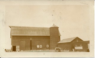
Frank mentions taking photos of the farm when he first visited it. That may be the source of these two photos of the farmhouse and barn.

2021-11-19. 1932 Farmhouse in country
(Click on images to enlarge)
This and the following image courtesy of Nick Hopman.

2021-11-19. 1932 Farm in Crown Point 1932

Again, thanks to Nick Hopman, we have Frank Willy's own story about the early days on the farm, and what the construction of the new Lincoln Highway did for the family:
You kids first went to St. Peter and Paul's School. I had to drive you. But when I had no money to buy gas, I sent you to the Ainsworth school as the bus passed our house. The first day you came home you said you needed about $14.60 for books. Had to sell corn for $.12 a bushel. Had about $.60 over on that truckload. That shows you what the Great Depression was like. I did not sell any more, as Henry Bloom[4] said, "Don’t sell. I will go along with you if it takes ten years. I won't foreclose on the mortgage!" The mortgage was for $7,000. The next year we had the cinch bugs. Twenty acres of corn barely filled my little silo. The next year we had the great dust storm. Steady wind from the southwest. In Kansas the dust covered fences and buildings. People left their farms. We bit our lips and held on.

Had 12 acres of fine wheat. Wanted to cut it on Monday. Henry Bloom was out on Saturday. "You ought to cut it. Sometimes it don't pay to wait 'til it has fully ripe." Sunday night it hailed. Shocked everything flat. Holes in the tarpaper roofs. Cut off branches of trees. It was a quarter-inch thick on the ground. I raked the wheat field and got Hank Homeier[5] to come and thrash it. Blew the straw into the barn and got 60 bushels of wheat. I needed that straw. Also paid Koehler[6] $10 so I could cut some slough grass, and Old Nick (our hired hand) herded the cattle there. In 1934 the new highway (US 30-the Lincoln Highway) came through. Then I had it made. When US 30 road work was being done I rented a small area to the state for material storage. When the work was done, instead of having the state clean up the storage area by removing the remaining sand, gravel, and steel, I negotiated to do it myself, for a price of course. But instead of cleaning up the mess, I just sold the materials until they were gone.
For some reason, the 1939 Plat Book fails to show the new highway east of Colorado:

2021-11-19. 1939 Ross Twp - Willy farm
(Click on image to enlarge)

But the 1939 aerial view shows it clearly:

2021-11-19. Aerial photo 1939 Willy Farm (LakeBFJ-04-043)
(Click on image to enlarge)
Image from https://igws.indiana.edu/IHAPI/Map/.


This raises the question whether the 1874 cartographer just made a mistake about the road extending east of Colorado, and that mistake was perpetuated by subsequent map-makers who didn't bother to investigate for themselves. But I am going to ignore that possibility because it's just no fun at all.

Anyway, the 1950 Plat Book shows the new U.S. 30:

2021-11-19. 1950 Ross Twp. - Willy farm
(Click on image to enlarge)


As you can see from the 1939 aerial view above, the Willys' house and farm buildings stood on the west side of Colorado Street, north of U.S. 30. This photograph shows more clearly how the buildings were arranged in relation to Colorado Street, which runs diagonally across the bottom of the photo:

2021-11-19. Willy farm, Crown Point mail address
Image courtesy of Nick Hopman.


Frank and Catherine Willy farmed that land for 30 years, through the Great Depression, through World War II, and beyond. Their children grew up, moved out, started families of their own. Frank and Catherine bought a modern ranch house in the Green Acres neighborhood. In 1962, they sold their farm.

Here is the former Willy farm as it appears in the 1972 Plat Book:
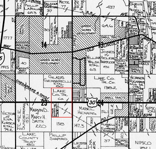
2021-11-19. 1972 Ross Twp. - former Willy farm
(Click on image to enlarge)

The new owner probably rented most of the land to locals who were still in the farming business.

This 1978 aerial view from the Lake County GIS website shows that the farmhouse and outbuildings have been removed, and some kind of business is operating in the northwest corner of the U.S. 30/Colorado intersection:

2021-11-19. 1978 aerial view (Lake County IN GIS)
(Click on image to enlarge)

The 1990s brought the era of the big-box store, and the landscape of the old farm was utterly transformed.


_______________
[1] He bought the south half of the northeast quarter, and the north half of the southeast quarter.
[2] Cf. Lake County Encyclopedia, p. 80. I'm a bit confused.
[3] "Nubbin" — a small or imperfect ear of corn [per the author].
[4] We don't know for certain who Henry Bloom was. My best guess is Henry Blume (1867-1958), who shows up in the 1910 Census farming his own land in Center Township, but in all subsequent censuses he gives no occupation. He and his wife, Mary, had only one child, who died in 1920.
[5] I think this was Henry Homeier, who farmed northeast of Merrillville.
[6] I give up.


Friday, July 3, 2015

Electrocution on Water Street

The evening of March 10, 1922, former photographer John J. Naumann turned off the light.

2015-7-3. John Naumann death
(Click on image to enlarge)
Hobart News 16 March 1922.


The nearly illegible line in the second paragraph reads, I think, "dining[?] room in the Banks home, Mr." — the Banks home being, I suppose, the home of Nathaniel P. Banks, who was John Naumann's father-in-law (and who had lost his wife a year earlier). The 1920 Census shows the combined Banks and Naumann families living on Water Street, but does not note the house number. The address given for N.P. Banks in the 1930 telephone directory is 600 S. Water Street.

By contrast, the Gazette's report did not mention recent rains, suggesting instead that the tragedy might be explained by the discovery, the next day, of "crossed wires on a pole near George Stoecker's flats, one of the wires carrying a high voltage for running motors." ("John J. Naumann Accidentally Killed Friday Night," Hobart Gazette 17 March 1922.)

Wednesday, December 4, 2013

Clara Chandler Banks, 1850 – 1921

She grew up in the village of Deep River; her parents are buried in Chester Cemetery; and she raised her own family on a farm straddling the Ross-Hobart Township line; so I ought to take notice of her passing.

Obituary of Clara Chandler Banks
(Click on image to enlarge)
From the Hobart Gazette, 14 Jan. 1921.

Friday, March 23, 2012

Fannie Nash Werner

Fannie Nash Werner
(Click on image to enlarge)
Image courtesy of the Hobart Historical Society.


This is Fannie Nash Werner, who sang at the funeral of Samuel Quinlan. The caption under the original at the museum describes her: "Teacher who, with the Woman's Reading Club, spearheaded the campaign to get this building [now the museum] as a library."

The photo is undated. What little I can see of her dress suggests the 1880s to me. Fannie was born around 1869, so this could be the late 1880s. In 1895 she married Fred H. Werner, who later became a dentist.

The photo below, also undated, looks a little earlier. The three young women seem to be dressed up for some event.

Fannie Nash Werner
(Click on image to enlarge)
Image courtesy of the Hobart Historical Society.

Monday, June 6, 2011

Buy More Liberty Bonds!

yourfarmshelled
(Click on image to enlarge)
This scary ad was part of Hobart's third Liberty Loan drive.


Late in March 1918 word came down from Washington that the third Liberty Loan issue would be in the amount of $3,000,000,000. Lake County's allocation was $3,000,000 in Liberty Bonds, with Hobart's quota being $80,000.

The people of Hobart were determined to meet their quota.

The townspeople gathered in the High School Auditorium on March 26 to get the ball rolling. They elected town board president James Carpenter as permanent chairman of the Liberty Loan committee. Several prominent citizens volunteered their services to help organize and direct the selling of bonds. An executive committee consisting of H.W. Paxton, John Gruel and William J. Killigrew devised a pseudo-military sales organization: Hobart and Ross Townships were divided up into "districts"; each district was managed by a "captain," who then appointed "lieutenants," who would go out and solicit Liberty Loan subscriptions, reporting back to the captain on their results.

By the following week, the 11 captaincies had been filled by John Dorman, Sam Woods, William Lennertz, Silvester Gross, John Lutz, John Larson, Jr., William Earle, Carl Olander, Hugo Zobjeck, John J. Wood and Emil Scharbach.

The drive began on Monday, April 8, with 100 men and women making a house-to-house canvass for subscriptions. By the evening they had sold about $30,000 in Liberty Bonds. Tuesday's work added another $10,000 in subscriptions. By the end of the week, District No. 1, captained by John Dorman, was far in the lead, with $15,000 in sales (lieutenant W.H. Wood alone having sold $7,600 worth); its next closest competitor was Emil Scharbach's District No. 11, with $3,500. The Gazette mixed reportage with exhortation: "Every citizen is now expected not only to do his 'bit,' but his 'most.' Open your purse strings and give till it hurts."

On the evening of Monday, April 15, Hobart's streets were packed with marchers and spectators as the Liberty Loan parade, directed by Calvin C. Shearer and Marshal Fred Rose, moved in a slow circle around the heart of the town. In the lead were four aging Civil War veterans (N.P. Banks, Conrad Bender, Matt Franzen and Charles Niksch). They marched to music played by Hobart's militia company. Following behind them were representatives of "every society and organization in Hobart," including the Boy Scouts, the Campfire Girls, and fraternal organizations such as the Masons, Royal Neighbors, Eastern Stars and North American Union. Hundreds of children and young adults, ranging in age from four years to the late teens, joined in the march.

The procession moved from the high school onto Main Street, then north through downtown to Second Street, then to Center Street and back to the high school, where the whole crowd squeezed into the auditorium. Dr. E.M. Linton of Indiana University took to the stage; after giving some rough treatment to an effigy of the Kaiser, he lectured on the war and its causes. Next, attorney Roscoe R. Peddicord announced that Hobart had already subscribed for $50,000 of its $80,000 allotment, and that the aim of this meeting was to make up the deficit. Canvassers spread out among the audience to collect subscriptions. Acting as secretary, attorney Alta Halstead spent an hour scribbling down names and amounts — which, by the evening's end, added up to another $10,000.

On April 18, the News reported that Hobart was still $15,000 short of its quota, and added a veiled threat: "The committee and captains will hold another meeting next Tuesday evening at the town hall, after which a list of every individual subscriber in this territory will be compiled. IF YOU HAVE NOT ALREADY SUBSCRIBED FOR A LIBERTY BOND, DO SO AT ONCE."

♦    ♦    ♦

From La Porte, Indiana, came a report that a non-naturalized German resident had been thrown in jail "for disloyalty." The allegations against him were that he had said he wanted Germany to win the war, and that he refused to buy a Liberty Bond.


Sources:
♦ "Everything Ready for Liberty Loan Drive." Hobart Gazette 5 Apr. 1918.
♦ "Hobart Has Big Patriotic Meeting." Hobart Gazette 19 Apr. 1918.
♦ "Hobart Has Subscribed $65,000 of Liberty Loan Quota." Hobart News 18 Apr. 1918.
♦ "Hobart's Liberty Loan Parade Proves a Big Success." Hobart News 18 Apr. 1918.
♦ "Jailed for Disloyalty." Hobart Gazette 26 Apr. 1918.
♦ "The Drive Is On." Hobart Gazette 12 Apr. 1918.
♦ "Third Liberty Loan Drive, For $3,000,000,000, on Next Week." Hobart News 28 Mar. 1918.

Saturday, May 21, 2011

Streetcars, 1911 and 1912

streetcar 1911
(Click on images to enlarge)
All images in this post courtesy of the Hobart Historical Society.


From notes on the reverse of this postcard we know that this photo was taken in Gary on May 4, 1911, and that two of the men are Louis Maybaum and Grover Linton (presumably the two standing in front, but the notes don't specify which is which). It would have to be Gary, since streetcars were not running in Hobart in 1911.


The image below comes from a postcard dated March 4, 1912.

Streetcar ca 1912

The reverse is rather interesting.

streetcar 1912 reverse

It's addressed to Mrs. Gilbert Bullock, who apparently is vacationing in Florida. I suppose that's our Estelle, though I haven't checked the census records to see if it might not be some niece-in-law of hers.

Her Hobart correspondent writes (I will insert some punctuation for her):
Dear Mrs. Bullock, Should Have written to you before. We are still Haveing Winter. Glad you are feeling better. Both of you. All aboard for Gary. Here is the car but the trouble is there is nothing to run it on. We missed you at auxillary last week. Best regards, Mrs. Banks.

Sunday, March 6, 2011

An Evening for the Books

VictoriaHotelca1910
The Victoria Hotel in Gary, Indiana, circa 1910. Image courtesy of the Northwest Indiana Genealogical Society.

The Victoria Hotel was the venue for a dance on the evening of October 2, 1917, sponsored by the staff of the Gary public library. Its purpose was to raise money for a library fund to benefit soldiers and sailors. Bessie Banks of Hobart had been on the Gary library staff for three years, and she probably urged her Hobart friends to attend.

A dozen young people from the Hobart-Ainsworth area came to dance the night away, including our own Will Wollenberg, Jr. With his musical and athletic talents, Will Jr. was probably a good dancer. Frank Ferguson, George Barnes, William and Howard Krull, and Ralph Banks went with him. Perhaps those six paired up with the half dozen young Hobart ladies who also attended — Harriet Morris, Bessie Banks, Vera Barnes, Maude Scholl, Myrtle Wild and Florence Pio. (Myrtle Wild and Howard Krull married about three months later.)

I don't know what it says about Will Jr.'s military ambitions that in September he accepted a position with the American Trust and Savings Bank in Hobart. Had he given up on his West Point hopes? — or was he just trying to make a little money while waiting for that nomination to come through?

Anyway, by mid-October Will had left the bank, hired by his own father to "look after coal yards" in Chicago. Back in March 1915 Will Sr. had expanded his business operations to include coal sales, having built some storage sheds at Ainsworth, so perhaps Will Jr. was to act as a purchasing agent; or perhaps Will Sr. actually owned coal yards in Chicago.


Sources:
♦ "Krull-Wild." Hobart News 17 Jan. 1918.
♦ "Local and Personal." Hobart News 13 Sept. 1917; 4 Oct. 1917.
♦ "Many Changes of Employes Taking Place in Hobart." Hobart News 18 Oct. 1917.
♦ "Miss Bessie Banks Resigns From Gary Library Staff." Hobart News 10 Jan. 1918.
♦ "Personal and Local Mention." Hobart News 11 Mar. 1915.

Thursday, March 11, 2010

A Great Fall

SautersPlace
(Click on image to enlarge)
Image courtesy of the Hobart Historical Society.


I think there was a barbershop on the second floor of the brick part of Ed Sauter's blacksmith shop, reached by means of that external wooden staircase you see in the picture. The reason I think so is because the stairs leading to "the barbershop upstairs in the Sauter building" once collapsed, and if I had to choose which part of these structures looked most likely to collapse, I'd definitely say that outdoor staircase.

The accident happened in May 1904, after Ed had sold his saloon to Claus Ziegler.

On the evening of Saturday, May 21, several young men were standing on the staircase outside the barbershop when the structure gave way beneath them and they all fell to the ground below. Some of them were badly injured, including 18-year-old Eugene Chandler, whose collar bone was broken. Apparently none of the injuries were fatal, however.

♦    ♦    ♦

The barber, or one of the barbers, of Ainsworth was named Lee Hunter. A few months after this incident he moved to California, and wrote back in December 1904 to say that he was not impressed with that part of the country. And that's the kind of random, useless information you can get from reading old newspapers.

Oh, and Eugene Chandler was the nephew of N.P. Banks, a Hobart farmer apparently so well known that the Gazette simply gave his name with no further identifying information.


Sources:
♦ 1900 Census.
♦ "Ainsworth Pick-Ups." Hobart Gazette 16 Dec. 1904.
♦ "General News Items." Hobart Gazette 27 May 1904.


[3/16/10 update: D'oh! Maybe N.P. Banks was well known because he was an officer and director of the First State Bank and a school trustee as well as a farmer.]