Showing posts with label Big Maple Lake Park. Show all posts

Thursday, January 2, 2025

The Lost Cemetery of Ainsworth Road

This post is based on research by local historian Michael White, who first pieced together the bits of information from various sources that pointed to an unaccounted-for old cemetery in Ross Township along with its general location. He was kind enough to clue me in.


The Rev. T.H. Ball, our legendary Lake County historian, in 1872[1] compiled a list of all the cemeteries he knew of in each township in the county. In the list for Ross Township, he included six cemeteries, five of which clearly correspond to ones we can identify today and can find in the Northwest Indiana Genealogical Society's Ross Township Cemeteries. But one item in Ball's list is a puzzler:
An old burial place near the Wilkinson Ford of Deep River, from which some bodies have been removed, but where many yet remain. This old spot is now part of a cultivated field. It seems a pity that the little ground required to receive the dust of human forms may not remain undisturbed. This spot ought yet to be rescued from the plowshire [sic], consecrated, as it has been, by the burial of old settlers; or the human remains there resting should be removed to a quiet cemetery which is sacred to repose.
Elsewhere in the same book, in listing early settlers of Lake County in the 1830s, Ball says: "The third family arriving was that of Robert Wilkinson, who settled on Deep River, where the only ford known in early times was situated."[2] (I have previously discussed my reasons for thinking that Ainsworth Road was part of the old Sauk Trail, predating white settlement. The indigenous people may have established the trail because there was a natural ford in the Deep River where Ainsworth Road crosses it — a natural ford that the white settlers would then have used as they trickled in along the trail during the 1830s.)

In another of his books, Ball tells us that in the 1830s a bridge "across Deep River at B. Wilkinson's crossing near the Porter county line [was] built by Amsi L. Ball, cost[ing] four hundred dollars."[3] So far we've heard only of Robert Wilkinson; who was B. Wilkinson? To find that out we have to turn to the "History of Lake County, 1833 – 1847" by Solon Robinson, as printed in 1929:[4]
The first family that came after Childers and myself [Solon Robinson] was that of Robert Wilkinson, (at the place where his brother Benijah now lives on Deep River; at that time, the only known crossing place.) He settled about the last of November, 1834. … Wilkinson lived a few years where he settled, when he moved off and his brother took his place.
So "B." stands for Benijah — or, as it is sometimes written, Benajah — and he succeeded his brother Robert on the settlement near the ford of the Deep River.[5]

Robinson's account includes, among a list of bridges built in 1837, a bridge "across Deep River at Benajah Wilkinson's [built] by A. L. Ball, for $400, besides several smaller ones, by means of the 3 per cent fund."[6]

Goodspeed and Blanchard's 1882 county history also mentions this $400 bridge built by A.L. Ball, and specifies that it was in "Section 16, Township 35, Range 7."[7]

Here is that section as it appears on the 1874 plat map:[8]

2025-01-02. Sec. 16, Twp. 35 N, Range 7 W (1874)
(Click on image to enlarge)

The only road that crossed the Deep River in Section 16 was Ainsworth Road, aka the old Sauk Trail.

Incidentally, Goodspeed and Blanchard tell us that in 1837 three township trustees were appointed for Twp. 35, Range 7 (Ross Township): John Wood, whom everybody knows; Robert Wilkinson; and William Hodson (whose orphaned sons I believe we've already met).[9] So Robert Wilkinson was still in Ross Township some three years after settling there.

The only early land purchase record I could find pertaining to the Wilkinson brothers and Section 16 shows Benajah buying 38 acres described as "Part Lot No. 5" on July 27, 1840.[10] That may have been the year Robert moved on.

Benajah appears in the 1840 census for the Ross Township area of Lake County;[11] his brother does not.

2025-01-02. 1840 census, Benajah Wilkinson
(Click on image to enlarge)
Image from Ancestry.com.


In August of 1849, Benajah Wilkinson died.

2025-01-02. U.S. Census Mortality Schedule for Indiana, 1850, Counties L-Z, p. 15
(Click on image to enlarge — a bit; sorry about the quality)
Image from Indiana State Library Digital Collections, U.S. Census Mortality Schedule for Indiana, 1850, Counties L-Z.


There is now no record of where he was buried. I am willing to bet that it was in the lost Wilkinson cemetery.

The 1850 census shows his widow, Prudence, and her children still in Ross Township.

2025-01-02. 1850 Census, Prudence Wilkinson
(Click on image to enlarge)
Image from Ancestry.com. Evidently the family was in Michigan in 1836 when their daughter, Electa, was born. The first of their children to be a native Hoosier was born in 1839.


Sometime after that they left Indiana.[12] Prudence died in 1885 in Minnesota.

♦    ♦    ♦

So where, exactly, is the lost cemetery? It was somewhere along Ainsworth Road, near the Deep River — but how near? which side of the road? which side of the river? I'm thinking that it would probably be on the west side of the river, because on the east side there is a long stretch of river bottom that often floods — but further east the land rises again, and we're back to not knowing how T.H. Ball measured his "near the Wilkinson Ford of Deep River."

It's just possible that his lament about plowing over consecrated ground might have spurred action. I have done a little searching in the on-line newspapers from 1873 onward for any story about relocating the remaining bodies from the Wilkinson cemetery, but I have found nothing.

Some of the land where the cemetery could possibly be now belongs to the Lake County Parks Department. In the years that I have lived here, I have spent many hours walking my dogs all over that land without ever seeing any evidence whatsoever of a cemetery — and, believe me, I am always on the lookout for interesting artifacts in the underbrush.

I suppose this will have to be one of the mysteries of Ainsworth.

_______________
[1] T.H. Ball, Lake County, Indiana, from 1834 to 1872 (Chicago: J.W. Goodspeed, 1873). The Ross Township burial places are listed at pp. 139-140.
[2] Ibid., p. 26.
[3] T.H. Ball, Encyclopedia of Genealogy and Biography of Lake County, Indiana, with a Compendium of History 1834 – 1904 (Chicago: The Lewis Publishing Company, 1904) (hereinafter, "Lake County Encyclopedia"), p. 10.
[4] Lake County Historical Association (John O. Bowers, Arthur G. Taylor, and Sam B. Woods, eds.), History of Lake County, Vol. 10 (Gary, Ind.: Calumet Press, 1929) (hereinafter, "Lake County, Vol. 10"). Solon Robinson's "Lake County, 1833 – 1847" starts on p. 35.
[5] Research on Robert Wilkinson is complicated by the fact that there were two early settlers by that name; in Ball's discussion in Lake County Encyclopedia at pp. 2-3 he mentions both, apparently distinguishing them. The one we're concerned with settled on Deep River for a short time, then gave his farm over to his brother and disappeared from history; the other settled in West Creek Township, and since he was more prominent in society and politics, more is written about him.
[6] Lake County, Vol. 10, p. 48.
[7] Weston A. Goodspeed and Charles Blanchard (eds.), Counties of Porter and Lake Indiana. Historical and Biographical. Illustrated (Chicago: F.A. Battey & Co., 1882), p. 422.
[8] Hardesty's Sectional Map of Lake Co. Indiana (Chicago: Rufus Blanchard, n.d. (the map's date is estimated at circa 1874)).
[9] Goodspeed and Blanchard at p. 421.
[10] Northwest Indiana Genealogical Society, Early Land Sales and Purchases, Lake County, Indiana, 1837 – 1857 (Valparaiso: Northwest Indiana Genealogical Society, 2006), p. 41.
[11] Yes, his name is written as "Benjamin," and no, the census does not specify the township, but among his neighbors are John Wood and some of the people who appeared in the NWIGS' listing of 1840s land purchases for Section 16, Twp. 35 N, Range 7 W.
[12] On Ancestry.com, I have found some records of Prudence Wilkinson buying land in Minnesota in 1860, but I cannot find the family in the 1860 census.

Sunday, December 31, 2023

Sign-Eating Tree III: The Re-Awakening

They cut it down. Did they think it was finished?

2023-12-31. Sign-Eating Tree
(Click on image to enlarge)

This is like the part of the movie where the hero thinks they have killed the villain but then makes the mistake of turning their back on the vanquished foe. Or maybe it's the part where the supporting character you think has abandoned the hero suddenly shows up again to help save the day.

But, as you may have noticed, the regrowth of the Sign-Eating Tree has recently been mangled by one of those big sideways-mowing-machines that went through cutting back all the forest growth along the roads in this area. I don't know what part of the movie that is.


Anyway, Happy New Year from Ainsworth!

Monday, December 5, 2022

Drug Money in Ainsworth

Today I want to look at the northeastern part of Ross Township as shown on the 1939 Plat Map.

2022-12-05. Schmitt - 1939 Plat Book
(Click on image to enlarge)

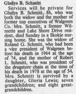
Sometime during the 1930s, Roland G. and Gladys B. Schmitt quietly bought up farmland that had belonged to two of Ainsworth's long-time residents, Charles Chester and Henry Nolte.[1] If I'm reading the plat map correctly, by 1939 the Schmitts owned some 400 acres. Where, during the Great Depression, would the money for that kind of purchase come from? The answer is: drugs. Roland Godfrey Schmitt was an executive with the expanding drugstore chain, Walgreens.

Born in Warsaw, Illinois, in 1890, he had started with Walgreens when he was just 20 years old and the chain itself not quite 10.
Roland G. Schmitt’s path to and through Walgreens would become a well-worn one, and it is still traveled today. The very day he enrolled in the Illinois School of Pharmacy in 1910, he noticed a “help wanted” announcement on a bulletin board at the school for a part-time apprentice at Walgreen’s first store at the corner of Cottage Grove and Bowen avenues. In the same youthful spirit that Walgreen demonstrated when he hopped on a train from Dixon to Chicago 17 years earlier, Schmitt stepped on a streetcar that afternoon, introduced himself to Arthur Thorsen — who was impressed by the young man’s wit and warmth — and accepted Thorsen’s offer of $8 a week (just $3 more than Walgreen earned after he got off the train almost two decades before).

Schmitt worked at the store every morning for an hour and a half, took the same streetcar back to school for a day of classes, then returned to the store to work from 6 P.M. to midnight — then got up and did it again after a few hours of sleep. After graduation, Schmitt became a full-time employee, a store manager, and finally the vice president of store operations — an unusually well-liked man with an easy smile. He retired in 1960, after putting in a very productive half century with Walgreens.[2]
In 1912, Roland married Amanda Schilling. By the 1920 Census — at which time there were 23 stores in the Walgreens Chain[3] — Roland and Amanda were living on Chicago's south side with their one-year-old son, Roland Jr. In September of 1922, Amanda died. Five months later, Roland Sr. married Gladys Forsaith. Together they would have two more children, Robert and Gloria.

The Schmitt family remained Chicago residents, per the 1930 and 1940 censuses. For them and their relatives and friends, I expect the farm was something of a vacation home. It was still a working farm, though. Roland Schmitt turned it into a big chicken-raising operation, producing eggs to sell in Walgreens stored. He hired local people to operate it. Among them, for a few years, was my late friend Eldon Harms. These are my notes from a conversation with Eldon in 2010:
The chicken houses were near the main house,[4] north and west of it on the same side of Ainsworth Road. They had some 2,000 chickens. Eldon worked on weekends, earning enough money to pay for his own textbooks (he was in high school at the time) and one suit of school clothes, and then his parents bought him another so he had a change.

The hens were all in nests along the walls. You had to go collect the eggs a couple times a day; if you left them there they'd be broken when the hens got to fighting over the nests. Eldon also had to clear out the old straw and lay down fresh, and if you want to hear some singing, you should have been there when the hens got the fresh straw. They just loved it.

The eggs had to be carried down into the storeroom in the basement of the house. They had one of those outside entrances, too. Twice a month a big green semi-trailer would come out from Chicago to collect the eggs.

He didn't earn a lot of money, but it was better than nothing.
I'm guessing the Schmitts built the guest house of which the chimney still stands in the woods north of Big Maple Lake. The main house was certainly large enough to accommodate guests, but a rustic cabin out in the forest (with indoor plumbing and gas piped in) would have been a more vacation-like getaway.

In December 1943 the Schmitts sold off their Ainsworth farm. I will get to that episode soon.

♦    ♦    ♦

Here is Roland's obituary from the Dixon Evening Telegraph of December 29, 1964.

2022-12-05. Roland Schmitt obituary. Dixon Evening Telegraph, 29 Dec. 1964
(Click on images to enlarge)

And Gladys', from the Chicago Tribune of August 13, 1987.

2022-12-05. Gladys Schmitt obituary, Chicago Tribune, 13 Aug. 1987


_______________
[1] As we know, Henry Nolte had been murdered in 1934, leaving no immediate family. Charles Chester was still living, but I am told by descendants of his that financial problems compelled him to sell, sometime in the 1930s, the farm that had been in his family for nearly a century.
[2] John U. Bacon. America's Corner Store: Walgreens' Prescription for Success. Hoboken, N.J.: John Wiley & Sons, Inc., 2004.
[3] "Walgreen Drug Stores," Chicagology (https://chicagology.com/walgreens/).
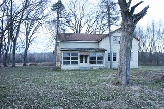
[4] The former Chester house, which stood on the west side of Big Maple Lake and was demolished in 2021.

Sunday, April 17, 2022

Bloodroot Colony

Happy Easter from this colony of Bloodroot blooming in Big Maple Lake Park.

2022-04-17. Bloodroot 3
(Click on images to enlarge)

2022-04-17. Bloodroot 2

2022-04-17. Bloodroot 1

2022-04-17. Bloodroot 4

Friday, April 15, 2022

Requiem for a Sign-Eating Tree

2022-04-15. Sign-eating tree
(Click on image to enlarge)

The tree that had eaten the "NO HUNTING" sign down to "HUNT" by 2009 continued eating over the years until lately the sign just said, "UN." I was going to photograph it for an update, but I waited too long. Now tree and sign have both fallen, and how, I ask you, will the future generations of Ainsworth be told about "UN"?

There's been a whole lot of tree- and brush-cutting around here in anticipation of a big utility-pole-replacement project coming up. The tree people cut down numerous invasive species that were growing on my property, thus saving me some work.

Thursday, November 25, 2021

Chester's Grove

This Thanksgiving, I am grateful for trees.

The Lake County Parks people have been very busy lately around Big Maple Lake, and now the old Chester place has a grove of saplings in what used to be the back and side yard.

2021-11-25. Chester's grove
(Click on images to enlarge)

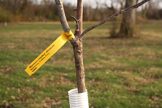
There is an interesting variety of trees: Kentucky Coffee Tree (I don't know much about trees, I just read the labels):

2021-11-25. Kentucky Coffee Tree

This one is Black Cherry:

2021-11-25. Black Cherry

And this is Ohio Buckeye:

2021-11-25. Ohio Buckeye

And Pin Oak:

2021-11-25. Pin Oak

In another ten or twenty years, I expect, Chester's Grove will be lovely.

Along the gravel road that leads back of the lake, they have planted some Cucumber Trees. I am looking forward to seeing how those turn out.


In other tree news, I discovered a little volunteer oak sapling in my field. From the looks of it, I had run over it with my brush mower last spring (maybe the spring before, too), not even realizing it was there. But now I have marked it so I will never run over it again.

Tuesday, November 9, 2021

The Maples on the Old Chester Place

I stopped by the old Chester place late yesterday afternoon to photograph the lovely foliage of the maples there.

This shot would have been impossible a year ago, when the house was still standing:

2021-11-09. Maples through house
(Click on images to enlarge)


Looking east along Ainsworth Road:

2021-11-09. Maples along Ainsworth


The side yard, and the setting sun shining through the leaves:

2021-11-09. Maples in the sun


The back yard, looking toward Big Maple Lake:

2021-11-09. Out back


Maybe someone who actually knows something about trees can tell me if any of those are old enough to have been planted by a Chester. Maybe they are the Wasy trees, I don't know.

Wednesday, March 24, 2021

The End of the Road for Henry Chester's House

After 140 years, Henry Chester's fine brick house is slowly but surely coming down.

2021-03-24. Henry Chester house demolition
(Click on image to enlarge)

Friday, April 24, 2020

Broken Nehi Bottle in the Woods

Having learned about the rope-like embossing on Nehi soda bottles, I knew what this fragment was even before I turned it over to find the traces of a painted label.

2020-04-24. broken Nehi bottle
(Click on image to enlarge)

Found in the woods north of Big Maple Lake.

Sunday, April 21, 2019

Happy Easter!

Here are some mayapples sprouting up from the ground in the woods behind Big Maple Lake.

2019-04-21. Mayapples
(Click on image to enlarge)

Monday, April 2, 2018

Just Like Old Times

Now that they've cut down the hundreds of trees that had grown up around the Chester house (aka the Wasy house), the landscape looks a bit more the way it did when the first brick was laid.

IMG_9218
(Click on image to enlarge)


I don't know what plans led the park people to cut down those trees, but I took about 40 pictures of the Chester house in case it meets the same fate as the Crisman house.

Wednesday, August 17, 2016

The Chester House Again

2016-8-17. image009
(Click on image to enlarge)
Image courtesy of John Fleck.


This is the Chester house, as seen from the west, and I'm not kidding when I say I really appreciate getting such a good view of Ainsworth Road itself … which would have been called the Chester road when this photo was taken.

Exactly when that was, I do not know. The reference in the caption to the late 1800s may mean the era when Carrie Raschka lived there. The number of electric or telephone wires strung along the road suggests at least a couple decades' worth of twentieth century. The porch pillars have been remodeled from their original appearance (compare the two "then" photos in the series linked to above), and I believe that was done in the early 20th century.

I may try a then-and-now in the middle of next winter, but I'm not sure it's possible, even with the leaves off the trees — the former side yard, the site of some of those outbuildings, is just too thickly grown over.