Showing posts with label Wasy. Show all posts

Thursday, September 28, 2023

How to Get Injured in Ainsworth When You're Eleven

One way is to fall out of your neighbor's hayloft.

2023-09-28. 1956-09-22 Gazette, Injured in Fall from Hay Mow
(Click on image to enlarge)
Hobart Gazette, 22 Sept. 1956.


This issue of the Gazette was published on Danny's twelfth birthday.

The article immediately to the right suggests a way to get a traumatic brain injury in Hobart when you're twelve.

Tuesday, November 9, 2021

The Maples on the Old Chester Place

I stopped by the old Chester place late yesterday afternoon to photograph the lovely foliage of the maples there.

This shot would have been impossible a year ago, when the house was still standing:

2021-11-09. Maples through house
(Click on images to enlarge)


Looking east along Ainsworth Road:

2021-11-09. Maples along Ainsworth


The side yard, and the setting sun shining through the leaves:

2021-11-09. Maples in the sun


The back yard, looking toward Big Maple Lake:

2021-11-09. Out back


Maybe someone who actually knows something about trees can tell me if any of those are old enough to have been planted by a Chester. Maybe they are the Wasy trees, I don't know.

Monday, April 2, 2018

Just Like Old Times

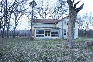
Now that they've cut down the hundreds of trees that had grown up around the Chester house (aka the Wasy house), the landscape looks a bit more the way it did when the first brick was laid.

IMG_9218
(Click on image to enlarge)


I don't know what plans led the park people to cut down those trees, but I took about 40 pictures of the Chester house in case it meets the same fate as the Crisman house.

Wednesday, May 24, 2017

Hobart Then and Now: The Miller Corner

1970s, and 2017.

2017-5-24. img887-d
(Click on images to enlarge)
Image above courtesy of the Hobart Historical Society.

2017-5-24. Miller corner 2017

I call this house the Miller house, because Eldon Harms told me that the Miller family lived there. But since I don't know when the house was built, I don't know who among the previous owners of that land might have lived there; nor do I know who might have lived there after the Millers ceased to own it. By 1950 it was part of Chester Wasy's extensive property, but surely he did not live there when he might choose the spacious Chester house or the riverside Nolte house.

If the house dated back to the early 1890s, it once housed Peter and Caroline Stolp, the maternal grandparents of Minnie (Rossow) Harms. They rented that farm for a short time. Peter may have died there (1892).

However, after that mystifying news item about John Miller moving his house, I don't know what to think.

The house was still standing when I moved here in 1990. By then it was painted green. There was a dog house behind it, and beyond the back yard a fenced-in area where a horse was kept, with a shed for its shelter. At the edge of the field to the south was a rusty farm machine — a tractor or some such thing. I liked that house. It was demolished before I began my historical research.

But getting back to the photo above — I'm dating it to the 1970s simply because of the style of photo. We have a similar photo, likewise undated, but taking in a car that looks like the sort of car you might see in the mid-1970s.

2017-5-24. img886-a
(Click on image to enlarge)
Image courtesy of the Hobart Historical Society.


These two photos were taken at least a few months apart, since here the trees are in full leaf, while in the first one the leaves are changing color and falling. I think this photo was taken when the Tonagels had their store up for sale. We have some others taken apparently at the same time with a better view of the automobiles that are helping me date these photos to the 1970s.

Tuesday, March 15, 2016

8 9 17 16
(Random Pointless Photos)

You can find this concrete marker among the trees north of Big Maple Lake.

2016-3-15. Big Maple Lake 1
(Click on images to enlarge)

This spot is (supposed to be) the meeting point of Sections 8, 9, 16, and 17 (of Township 35 North, Range 7 West).

2016-3-15. Big Maple Lake 2

So it also marked the meeting point of the Chester and Nolte farms … both of which eventually became the Wasy farm, and all of which is now Deep River County Park.


Here are Buddy and Robbie ignoring that concrete post and its aging metal guardian.

2016-3-15. Big Maple Lake 3


East of this spot, in what may be the tippy-top of Section 16, or the bottom of Section 9, among the ruins of the Nolte/Wasy farm, I found this:

2016-3-15. Big Maple Lake 4

2016-3-15. Big Maple Lake 5

A tree had grown up through the concrete floor of an outbuilding, then fallen over, and in doing so pulled up a section of the floor, exposing orange terra cotta tile under the concrete.


Here's Big Maple Lake.

2016-3-15. Big Maple Lake 6


Here's an artistic shot of sunlight sparkling on Big Maple Lake.

2016-3-15. Big Maple Lake 7


Here's Robbie getting in the way of the sparkles.

2016-3-15. Big Maple Lake 8

Wednesday, October 29, 2014

The Milk House

In our previous installment of Stuff That Used to Be Around Big Maple Lake, I mentioned the lingering remains of what appears to have been a small terracotta-block building with electricity. Here's the building those ruins seem to resemble:

2014-10-29. DRF Milk House 1947 001 detail
(Click on images to enlarge)
Images courtesy of Chester Wasy.


A milk house is where the full milk cans were kept cool in tanks of water until they could be shipped to the milk-bottling factory. In Henry Nolte's time, the electrical pump that drew water into the tanks was controlled by a big throw-switch on the wall. That switch always sparked when you turned it on, which scared the little neighbor kid who would tell me about it 80 years later.

That wheeled contraption out front is a milk cart, built to carry cans of milk from the barn to the milk house, and from the milk house to the truck that would carry them away to their rendezvous with destiny.

2014-10-29. DRF Milk House 1947 001

The problem I have with connecting this building to the foundation among the trees east of Big Maple Lake (small foundation, bits of terracotta blocks, porcelain insulators and shreds of metal wire) is that, as we see from the photo, the milk house was right next to the main house, and the ruins out in the woods that seem to correspond to the main house are at some distance from the little foundation. So I must be wrong about something, and perhaps many things.

Thursday, October 2, 2014

Nolte-Wasy Garage and Tool Shed

Somewhere in the woods between the Deep River and Big Maple Lake is the location of these two buildings …

2014-10-2. DRF Garage & Shed 1947 001 detail
(Click on images to enlarge)
Images courtesy of Chester Wasy.


… but I don't know where, exactly.

Here is the description from the 1947 property assessment report.

2014-10-2. DRF Garage & Shed 1947 001

The garage was made of Hobart terra cotta, or so I'm told. (While I have found a concrete foundation out there surrounded by fragments of terra cotta, the foundation looks too small to hold two cars; it might be another terra cotta outbuilding which we shall get to later.) It was built within Louis Nolte's lifetime, as Henry and Louis each had their own car to park in there — a Model T and a Model A, not sure who had which.

Tuesday, August 19, 2014

Nolte-Wasy Barn

Continuing our look at the 1947 photos of the former Nolte farm after it passed into the hands of the Wasy family, we come to this large, impressive barn.

2014-8-19. DRF Cow Barn 1947 001 detail
(Click on images to enlarge)
Images courtesy of Chester Wasy.


I wonder if this relates to the long concrete floor you can still find among the trees between Big Maple Lake and the Deep River? But again, there was plenty of time for other construction between 1947 and … whenever the Lake County Parks Dept. bought this property.

2014-8-19. DRF Cow Barn 1947 001

Sunday, June 15, 2014

The Former Nolte House, 1947

Here is the saddest house in Ainsworth, in happier times.

2014-6-15. Deep River Farm 1947 001 detail
(Click on images to enlarge)
Images courtesy of Chester Wasy.


This image comes from the 1947 property assessment report prepared for the Wasy family.

2014-6-15. Deep River Farm 1947 001

I do not know how much remodeling this house went through between 1934 and 1947 — not enough to make it unrecognizable to a former neighbor of the Nolte brothers!

As you may remember, this house stood on the west bank of the Deep River, on the north side of Ainsworth Road, east of Big Maple Lake. Mr. Wasy has told me that the property assessment report included a map showing the layout of this farm (houses and outbuildings), which he will send me when he is able; I am hoping that map will help me make sense of the ruins in the woods. I already have photos of the outbuildings and will get around to posting those eventually.

The Wasys lived here for two years before moving to the former Chester house.

Monday, June 9, 2014

The Wasy House, 1947

Formerly the Chester house, by 1947 it had been remodeled into (more or less) its present-day form.

6-9-2014 Wasy house
(Click on images to enlarge)
Images courtesy of Chester Wasy.


This photo was taken for the same property assessment report that gave us a look at the guest house.

6-9-2014 Chester Wasy Residence 001

Wednesday, April 9, 2014

Ainsworth Then and Now: The Guest House

Back when I took pictures of the house in the woods, I never expected to have a picture of it for a then-and-now post!

1947 and 2014

4-9-2014 Guest house photo
4-9-2014 Guest house now
(Click on images to enlarge)
Top image courtesy of Chester Wasy.


Mr. Wasy writes:
[T]he front porch faced the south and in the winter you could see the cabin from Ainsworth Road, of course that was when cattle grazed in the woods and kept the area clear.

During the winter my friend Cleston Brenan and I used to sled down the valley slopes then go back to the cabin and light a fire in the fire place to dry out. O what a good old time!!!
Another neighbor remembers sledding back there with friends as well, but being uninvited, they had to keep a lookout so "old man Wasy" wouldn't catch them — the senior Chester Wasy, that is.

The 1947 photo was taken for a report prepared on the property assessing its value.

4-9-2014 1947 Report on Atlasta Farms
(Click on images to enlarge)
Images courtesy of Chester Wasy.


4-9-2014 Guest house information

I am sorry to have to tell those of you who think this cabin belonged to Al Capone … well, it's a good story, but it's not true.

Sunday, October 11, 2009

Sketching Out My Land's History

Friday I went to the Lake County Recorder of Deeds' office in Crown Point, intending to research the ownership of my house. I found out that Lake County doesn't allow that. They gave me a "transfer sheet" showing the previous owner's transfer to me; beyond that, they told me, I have to go to a title company and pay big bucks for the information.

I haven't talked to a title company yet to find out how big the bucks are. The information may not be worth the price.

On the way back I stopped at the Lake County Central Library and spent three lovely hours in the Indiana Room, looking at old atlases, plat books and city directories.

I learned enough to sketch out an incomplete timeline of the ownership of my pitiful 3.5 acres:

1832 — Potawatomi tribe cedes it to the federal government.

1891 — owned by Henry Chester as part of a larger parcel enfolding the Grand Trunk Railroad in its 274.5-acre embrace.

1926 — owned by C.E. Chester, possibly Charles E., Henry's son; still part of a much larger parcel.

1939 — owned by J. Chester. Possibly James or Jerome, Henry's sons. Still part of a much larger parcel.

1966 — Hubert (probably Senior) and Delilia Lines own this small 3.5-acre parcel carved out of the big parcel that was previously in Chester hands but is now (1966) owned by Chester Wasy.

1979 — owned by Hubert and Carlene Lines (probably Hubert Jr.; Hubert Sr. died in 1977).

1990 — owned by me.

Sources:
♦ Allman Gary Title Company, Atlas and Plat Book of Lake County Indiana (Rockford: The Thrift Press, 1926).
♦ 1891 Plat Book for Appraisers of Real Estate Lake County, Indiana (Valparaiso: Northwest Indiana Genealogical Society, 2007).
♦ Lake County, Indiana, Real Estate Assessment and Transfer Record (10/9/09).
♦ Lake County Title Co., Plat Book of Lake County 1939 (n.p.).
♦ Manich, Steve W., 1966 Township Maps of Lake County, Indiana Showing Ownerships (n.p.).
♦ Manich, Steve W., 1979 Township Maps Lake County Indiana Showing Ownerships (n.p.).
♦ Schoon, Kenneth J., Calumet Beginnings (Bloomington: Indiana University Press, 2003).