Showing posts with label Grand Boulevard. Show all posts

Thursday, September 24, 2009

The Ambiguity of "Ainsworth Road," Part 2

George Norman, at Hobart, the Indian Ridge professional, is still concentrating his efforts on the permanent greens for the nine-hole outlay there. Indian Ridge is south of Hobart, on the Ainsworth Hobart road, next to the Dorman farm.
From The Lake County Times, Monday, June 14, 1926 (Hammond, IN) (emphasis added).

The Indian Ridge Country Club is still there, but the "Ainsworth Hobart road," which was also "Ainsworth Road," is now Grand Boulevard, State Road 51 and Lake Park Avenue.

I've never seen a town like Hobart for giving multiple names to the same street. It must be something in the water.

The Curious Incident of the Train Whistle in the Night

You'd think that, in this age of standardization, some corporate mandate would have set a uniform pattern for train whistles, and yet I hear them vary.

Most often I hear long-long-short-long, but I've also heard, for example, in just the last couple of weeks: long-short-long; a lone long from some lazy guy; short-short-short; and even short-short-short-short, which sounded positively playful. Westbound trains usually begin whistling east of my house, give a loud blast as they draw even with my house, and then continue blasting as they move on westward, so I hear the additional variation of the Doppler effect.

But once I heard a variation that made me think bad news.

This was a few years ago (and with my defective memory, a "few years" could be anywhere from two to ten), on an evening when I was so tired that I fell into bed early and starting drifting off to sleep. I had been living here long enough that trains passing on summer nights no longer jerked me awake in a panic; and the first blast of this train's whistle just half-registered in my sleepy brain. A standard long, a pause — then an insistent lo-o-o-o-o-o-o-ng that didn't let up as the train passed by my house, down the remaining hundreds yards and through the Ainsworth crossing. And then the whistle gave way to the screech and wail of a fast train coming to a hard stop.

"Something ain't right," I thought, but I hadn't heard the kind of loud crash you might expect from an accident, so I stayed in bed and tried to go back to sleep.

Then I heard the sirens.

I got out of bed and looked out the front door. There was the freight train, blocking the Ainsworth crossing; there were police cars, blue lights flashing; there were police officers milling around, and an ambulance pulling up, but I still couldn't see what, if anything, the train had hit.

I kept watching, out of natural if morbid curiosity. After a while the ambulance departed leisurely. Then a tow truck came, backed onto the right-of-way west of the Ainsworth crossing, and pulled out what remained of a black car.

Whoever left it on the tracks apparently got out before the train hit. That was lucky. I know of two people killed in train-car accidents along the Ainsworth part of the Grand Trunk.

To this day you can still find parts of that black car where the train left them.


Maya investigates the crash scene:
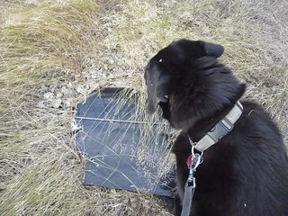
MayaInvestigates
(Click on images to enlarge)

It was a GM:
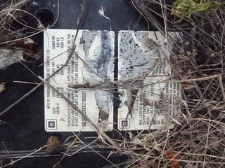
ItWasaGM

* * *

On the topic of lucky accidents, this just in from The Vidette-Messenger (Valparaiso, Ind.), Tuesday, March 10, 1931:
Seven Grand Trunk trainmen escaped injury Monday afternoon when the caboose in which they were riding overturned between Sedley and Ainsworth. Two work cars toppled over. It took the wrecking crew until 7 o'clock this morning to "right things." The train was backing from Ainsworth to the Deep River bridge, unloading ties, when it struck a giant snow drift and overturned, pulling the other cars with it. No one was injured.
There had been a big March snowstorm, I gather. Something like the one in March of 1998, when I spent a week without power, which out here also means without running water, but that's another story.

Monday, September 21, 2009

The Ambiguity of "Ainsworth Road"

1959 Sappers Ad

Above is part of a page from the Hobart Herald of July 9, 1959, which I bought yesterday at a Hobart antique store. At the bottom of the page is an advertisement for Sapper's Farm Market, which still operates today on State Road 51 just south of "the bend" where the east-west 10th Street bends into the north-south Grand Boulevard — both of them part of the sinuous State Road 51.

In the 1959 ad, the store's location is given as "Rt. 51 & 11th St. (Ainsworth Rd.)."

When I saw that, I said to myself, "Huh???" Isn't there about a mile separating the roughly parallel lines of 11th Street and Ainsworth Road?

So this morning I trotted over to Sapper's to ask for help, and I got it. Apparently State Road 51 south of "the bend" used to be called Ainsworth Road.

As if I weren't already confused enough! So eventually Ainsworth Road intersects with Ainsworth Road? Somebody, please shoot me now.

Wednesday, August 26, 2009

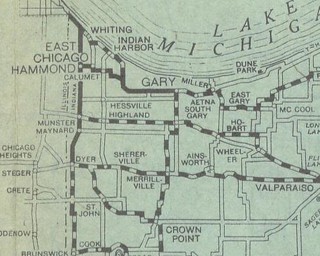
Lake County 1920

Northern Lake County

1920LakeCountynorthern

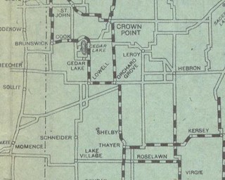
Southern Lake County

1920LakeCountysouthern

From Goodrich Travel and Transport Bureau - B.F.G.R. Company, Goodrich Road Map of Indiana (Akron, Ohio: Beck Raymond Commercial Print and Lithograph Company, c.1920), via the University of Alabama.

This map is disorienting. Ainsworth rates the same size typeface as Merrillville and Hobart. Grand Boulevard appears to have a significant east-west jog in it. The greater part of Ainsworth Road has simply disappeared.

But don't you just love the way the whole thing looks? Doesn't the whole style just say "1920s"?

Here endeth my University of Alabama adventure. The last Indiana map they have, 1940, is some kind of topographical or geological thing and not pertinent to this blog. Great site, though, and I am much obliged to the Alabamians.

Sunday, August 9, 2009

Aerial Photos: 1939 (2 of 3)

BFJ-04-071 enhanced
(Click on image to enlarge)

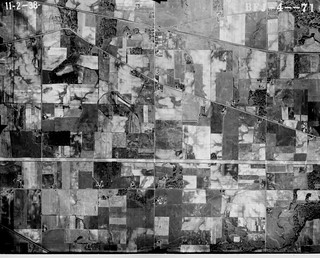
This photo was taken at nearly the same east-west position as the one from the previous post, but here we are positioned further to the south. The Ainsworth Triangle is nearly at the top of the photo, while the double horizontal line of Route 30 appears about a third of the way from the bottom.

The exposure is higher, which makes some features stand out more clearly, such as the building I spoke of earlier — the suspected railroad station — that sits right beside the Grand Trunk Railroad on the north side of the Ainsworth Triangle.

There is absolutely nothing at the junction of Grand Boulevard and Route 30.

On the southeast corner of Grand Boulevard and 73rd Street stands a house that has since been knocked down. Here it looks like a significant farming operation. By the time I moved into the area, it was just a house; out back was a shed where a horse stayed, and further out a rusting farm machine. I was fond of the old farmhouse and the weathered wood of the shed, and of course I liked the horse. Then I read in local newspaper a letter from a reader complaining about the existence of that very shed and horse, and the rusting farm machine. I was simply stunned that anyone could find it offensive.

Saturday, August 8, 2009

Aerial Photos: 1939 (1 of 3)

1939 Aerial Park (BFJ-04-070[2])
(Click on image to enlarge)

This photo is bisected vertically, just to the left of center, by Grand Boulevard, aka State Road 51. Almost at the center of the photo you can see the triangle formed by the intersection of Grand Boulevard, Ainsworth Road and the Grand Trunk Railroad.

Ainsworth Road here appears in its old configuration: it crosses the railroad tracks and connects with Grand Boulevard south of the tracks. These days it veers north to connect with Grand just north of the tracks, never crossing them at all. When I moved out here in 1990, you could still see a line in the pavement of Ainsworth Road that pointed obliquely toward the tracks, marking the road's old path. I don't know exactly when the change was made, but I believe it was post-1973. When they resurfaced Ainsworth Road prior to excavating Big Maple Lake, they covered up the line.

On the north side of the Ainsworth Triangle, you can just make out what appears to be a building right beside the railroad tracks. I suspect that was the railroad station. Two paths have been worn from Grand Boulevard to that building, as if by people coming from the north and from the south.

As you follow Grand Boulevard south, you can clearly see the dark square of the school building, halfway between Ainsworth Road and 73rd Street.

Looking east on Ainsworth Road, you find no trace of Shiloh Ranch or the sheep farm buildings. Once you pass the tiny house and barn at 6720, there is nothing until the collection of buildings that surrounded the house at the western border of what is now Big Maple Lake park. The house still stands today, and as for the outbuildings, you can find their ruins among the trees that have filled up the fields on both sides of the road.

Continuing eastward along Ainsworth Road, you come to a collection of buildings on the north side of the road, just edging the dense vegetation that marks the Deep River.

When I first started taking my dog for walks in the forest around Big Maple Lake, I noticed great blocks of broken concrete piled along the path at the east end of the park. I thought, who would go to all the trouble of driving up this little path to dump their debris in the park? What's wrong with people? and so on. But a little more exploration showed me that the debris hadn't been imported — it was the remains of some mysterious structure that had been built and then demolished on that site. Deep among the trees, among the thickets of poison ivy and the thorns of multiflora rose, I traced the concrete foundation of a long, narrow building. Elsewhere there were remnants of electrical conduit, fencing, gates, truck bumpers, glazed bricks and, further towards the river, what seemed an archeological treasure trove of garbage that people had dumped down the high, sloping bank of the Deep River. Further investigation of the remains and the garbage dump proved it all disappointingly modern, but I was still curious about what the structures had been and who had built them. I haven't found out yet.

Anyway, there they stand, pristine in an open field, in 1939.