Showing posts with label Underwood. Show all posts

Monday, September 18, 2023

The Harpers, the Other Harpers, and the Other Other Harpers

I thought I would just quickly research Calvin and Mary (Underwood) Harper of the brick house beside the Deep River, and figure out what (if any) relation they had to Ainsworth's other Harpers (Benjamin; Middleton; Robert; and Robert's aunt, Ellen, who married Cyrus E. Smith). I did research them, but it wasn't quick.

So first let me just get the basic facts about Calvin and Mary Harper, who built the brick house.

Calvin was born in Ohio on September 24, 1819, to William and Deborah (Thompson) Harper. William was a native of New York, Deborah of Vermont, but they had moved to Ohio by the time of their marriage in 1818.

Calvin married Mary Underwood in September of 1843, in Ashtabula County, Ohio. Mary had been born in 1822[1] to Harmon and Mary (Mather) Underwood, in New York. The family must have moved to Ohio by the 1840s, although I can't find them in the census. By 1850 Harmon, Mary, and several of their children had gone to Lake County, Illinois.

But their daughter Mary, now a Harper, did not go with them. Here we see her and Calvin, with their only child, Mayvorite, in Ashtabula County, Ohio, in the 1850 Census:

2023-09-18. 1850 Census - Harper, Calvin and Mary
(Click on image to enlarge)
Image from Ancestry.com.


You will note that their neighbors include Harpers and Thompsons, any of whom may have been relatives. The family of Benjamin and Ruth Harper is particularly interesting. Ruth was Mary's sister, who married Benjamin Harper in 1842 (in Ashtabula County). But what was Benjamin to Calvin? — per a family tree I've found on Ancestry.com, Benjamin was Calvin's uncle, but that tree doesn't cite any definitive sources.

In my earlier post about the land now occupied by Southlake Mall, I noted its purchase in October 1852 by Daniel Underwood. He must have been some a relation to Mary (Underwood) Harper — brother, probably, or uncle. According to Early Land Sales, Lake County, in that same month and year, her father, Harmon Underwood, bought at least 160 acres in Ross Township.

Calvin and Mary Harper came to Ross Township in 1850, according to her 1916 obituary;[2] if so, that must have happened after July 1850 when the census was taken. The land they eventually owned was purchased by James Halsted in June 1852. The 1860 Census records Calvin and Mary in Ross Township. While (as we know) early censuses don't give addresses, the Harpers appear as neighbors (on the census, at least) to Carter and Charlotte Castle, who owned land adjacent to James Halsted's 1852 purchase. This suggests that the Harpers were already on their farm on what is now Grand Boulevard, living in a predecessor to the brick house.

In 1868, Mayvorite Harper married Admiral[3] Rodney Castle. He was the son of Lysander and Maria Castle, born in Ohio in 1841 (Indiana Death Certificates). Lysander had died in 1851[4], and his widow married Samuel Lathrop. The 1860 census and the 1874 Plat Map show the Lathrop-Castle blended family as neighbors of the Harpers.

As for Benjamin and Ruth Harper, they were still in Ohio in 1860, but within the decade they also came to Ross Township, where the 1870 Census found them. According to the 1874 Plat Map, they owned a good chunk of land at the tiny village of Hickory Top (later Ainsworth). They probably lived in, and may have built, the house at 6305 Ainsworth Road, built in 1869 per the county records.

The children of Benjamin and Ruth were Mary, Ellen, and Frank.

Ellen married Cyrus Smith in 1861 in Erie County, Pennsylvania;[5] in 1863[6] they moved to the farm in Ross Township where they would settle permanently.

Ellen's brother, Frank Harper, married Ella Hopkins in 1878, here in Lake County, and they had two children: Cassie and Robert. Thus, Robert was Ellen Smith's nephew.


When it comes to Middleton Harper, things get murky. From his obituary and his grave marker, we know he was born in Montgomery County, Indiana, on December 10, 1850. Per his death certificate, his father was John Harper, born in Tippecanoe County, Indiana, and his mother was Sarah Frazier, born in "East Tenn." or maybe "East Penn."

Middleton first appears as a nine-year-old boy in the 1860 Census of Tippecanoe County. The household consists of his grandfather (I'm guessing), Middleton, born circa 1795 in Maryland, and his 27-year-old mother, who is described as widowed. (She has several children besides Middleton, and there is a 21-year-old William who may be her brother-in-law.)

The next glimpse I catch of Middleton Harper is not the 1870 Census — I can't find him in it — but the Indiana Marriage Collection, which shows him in Lake County, Indiana, marrying Anna Goodrich in 1872. You'd expect to find them in the 1880 Census, but you'd be disappointed.

We do find Anna Harper in the 1900 Census. By then she was widowed. We also find her in 1910 and 1920, living with her married daughters.

But that doesn't help us figure out if Middleton Harper was any relation to all these other Harpers. I just don't know.

♦    ♦    ♦

All of this was put together with online sources. If I ever get the time to go through microfilm and other offline sources, I may find out more.


_______________
[1] Indiana Death Certificates.
[2] "Descendant of Cotton Mather Dies at Miller," Porter County Vidette (Valparaiso, Ind.), 19 Apr. 1916.
[3] Yes, that was his given first name.
[4] He is buried on the south bank of the Deep River west of State Road 51; according to legend (as noted in the NWIGS's Ross Township Cemeteries), at the time of his funeral and even after two days' wait, the river was too swollen to carry his coffin across to the cemetery up the road in Hobart Township.
[5] This is according to his obituary ("Death of a Ross Township Citizen," Hobart Gazette, 8 Oct. 1915); I can't find a record of their marriage on Ancestry.com. I do wonder if this means that Ellen's family spent some time in Pennsylvania, between the time they left Ohio and the time they came to Indiana.
[6] Also from Cyrus' obituary.

Sunday, July 3, 2022

Ross Township School Report Card, 1875 (cont'd)

Having covered Alfred Winslow and the Brown's Point school last time, I shall now look at the other Ross Township schools described by the county superintendent of schools in 1875.

2022-06-21. REPORT ON SCHOOLS Crown-Point-Register-Feb-11-1875-p-2

(Click on image to enlarge)
Crown Point Register, 11 Feb. 1875.


The superintendent was not impressed by District No. 13. The school building was sparsely equipped, and the pupils and their parents seemed unenthusiastic. Based on the fact that the teacher here was Mary Underwood, I'm guessing that this was the one-room Underwood school. Mary was probably the 19-year-old daughter of Daniel and Sybil Underwood. (Three years after this report, she would marry Jackson Castle.)

District No. 1 was being taught by Asa Bullock. He was about 20 years old, the son of Moses and Amanda Bullock, and in 1875 probably still living where he was recorded in the 1870 Census, on the Bullock farm along 73rd Avenue. If he taught at the nearest school to his home, that would be the one-room Adams school on the northeast corner of Colorado and 69th. In spite of poor equipment, the superintendent says, "The teacher is quite thorough and is doing good work." As we learned from his obituary, Asa had formal training at a normal school and taught for some eleven years, before going into the practice of law. At his death, some of his former pupils still remembered him as "a good teacher."

Next we have District No. 2, which was especially bad. The (few) students' textbooks were "wholly unfit" while their seats were "a complete wreck, all broken and cut up." The teacher was Cyrus Smith, and since his farm, as we know, lay just west of the intersection of (present-day) Green and 73rd, I'm guessing he taught at the Ainsworth school, which in 1875 still had only one room. Cyrus' 1915 obituary said, "In his earlier days in Ross township, he taught school for eight years during the winter months." (During the other months, of course, he farmed.) The superintendent says nothing about how well the students were doing. Unless I'm reading too much into that silence, that suggests they weren't doing particularly well. Perhaps Cyrus — while evidently competent, since he kept getting re-hired — was not the sort of extraordinarily gifted enough teacher who could inspire the undersupplied students in their dilapidated school.

Moving on, we find that the "Merrillville Graded School" was large enough to need two teachers. Again, no maps or charts, but otherwise the report was favorable: "Order good; pupils pretty well advanced; good interest, and good attendance. Teacher quite thorough and doing good work." The teacher in this case, I believe, was Orsemus H. Spencer, whom we've met before only in passing (as the brother-in-law of Harriet Hanks Chester, and the brother of Charles Spencer). Mrs. Spencer, whose department the superintendent did not have time to examine, was the former Emma Gearhart, whom Orsemus married in 1871 (Indiana Marriage Collection). She was his third wife.

His first wife was Esther A. Tree, a native of Canada, who shows up in the 1850 Census in Porter County. Her father's name is illegible, but elsewhere[1] is given as Bradford; her mother's name is Lucinda; and Esther has a sister, Marilla, who eventually married Charles Spencer — so two sisters married two brothers. As for the Spencer family, originally from Ohio where Orsemus had been born in 1836, by 1850 they had settled in Hobart. As early as 1855 Orsemus began appearing in the Hobart Township Trustee's ledger as a teacher.

In 1856 Orsemus and Esther eloped (I'm guessing) to marry in Berrien County, Michigan. The 1860 Census shows the young couple, with their two small boys, farming in Porter County. In August 1862, Orsemus joined the 73rd Regiment, Indiana Infantry. Apparently he was taken as a prisoner of war, then paroled, and discharged from the Army in July 1863 for health reasons, suffering from "heart disease and rheumatism from exposure while in prison."[2]

Probably in April 1866, Esther died.[3] On May 20, 1867, Orsemus married Lucy Hanks. He and Lucy, with the sons from his first marriage, were recorded in Hobart in the 1870 Census, he giving his occupation as schoolteacher. Lucy died sometime in 1870 or 1871, though I can't determine exactly when.[4]

On August 18, 1871, Orsemus married Emma Gearhart. As late as June 1879 I find both of them in the Hobart Township Trustee's records, receiving pay as teachers. Perhaps it was that summer that they left for Kansas, where the 1880 Census found them, and where they lived out the rest of their lives. Orsemus died there in 1896. When Emma died in 1907, her body was brought back to Indiana for burial.

♦    ♦    ♦

This 1875 report does not cover all the schools in Ross Township. I would have liked to hear about the Green, Deep River, Hurlburt, and Vincent schools, all of which show up on the 1874 Plat Map in eastern Ross Township, as well as several others in the more westerly part of the township.

_______________
[1] In the 1900 death certificate of Esther's sister, Marilla Tree Spencer.
[2] Ancestry.com. Kansas, U.S., Enrollment of Civil War Veterans, 1889 [database on-line]. Provo, UT, USA: Ancestry.com Operations, Inc., 2013. Original data: Enrollment of Ex-Soldiers and Sailors, their Widows and Orphans, 1889. Unit ID #190462, 69 volumes. Records of the Adjutant General’s Office. Kansas State Historical Society, Topeka, Kansas.
[3] Per a family tree on Ancestry.com that does not cite a source for this information.
[4] I find information in the Crown Point Register, in the "From Hobart" columns of June 9, 1870, and June 23, 1870, about the illness and death of Mrs. O.A. Spencer, but if that is a misprint for O.H., then how could Lucy be recorded in the census on July 19, 1870? The same family tree mentioned in footnote 3 above gives June 3, 1870, as the date of Lucy's death but does not cite a source, and again, what about the census?

Saturday, February 12, 2022

The Farm Under the Mall

I recently mentioned the Underwood school, so now I'd like to talk about the family for whom the school was named, and the farm they owned for many decades.

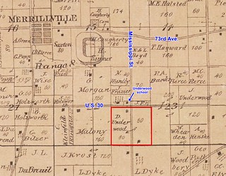
The 1874 Plat Map shows 160 acres straddling Mississippi Street, on the south side of present-day U.S. 30, owned by Daniel and Sybil Underwood.

2022-02-12. Underwood farm 1874
(Click on image to enlarge)

These days, of course, Southlake Mall sprawls over half of it, the other half teems with restaurants and hotels, and I-65 roars past its western border.


My imagination is not good enough to turn that into a family farm, much less virgin woodland or prairie.

The earliest record I can find of the Underwood farm is the purchase in October 1852 of the west half by Daniel Underwood (Early Land Sales, Lake County). The east half was purchased by Henry Wells[1] in 1854; how it got from him to Daniel I do not know. [Update: I think I was wrong about Henry Wells' purchase.]

Daniel was the son of Harmon and Mary (Mather) Underwood, both natives of New England who had moved to Ohio by the time Daniel was born in 1828. Sometime after 1840 the family moved to Lake County, Illinois, and it was there that, on November 7, 1854, Daniel married Sybil Huntley.

Sybil was likewise of New England stock. Her parents were Nehemiah and Lucy (née Dudley). This family, too, had relocated to Ohio, and eventually to Lake County, Illinois (with a stop in Winnebago County per the 1840 Census). If you look at the 1874 map above, you can find Sybil's younger brother, Nehemiah Jr., owning 40 acres north of Daniel and Sybil's farm.[2]

The 1860 Census shows Nehemiah and Lucy Huntley, along with Nehemiah Jr., living in the household of Daniel and Sybil Underwood and their two young daughters. Harmon and Mary Underwood are living nearby with two of their adult children, John and Ann. Harmon, as we already know, had bought the 160 acres that eventually became the Willy farm in 1852, and sold them to John in 1854.

Between 1854 and 1880, Daniel and Sybil had six children that we know of: Mary, Emma, Florence (or Flora), Clara, Frank, and Jessie.

In 1886, Sybil unexpectedly died.

2022-02-12. Underwood, Sybil - obit - Crown-Point-Register-October,14-1886-p-3
(Click on image to enlarge)
Crown Point Register, October 14, 1886.


The location given for Daniel and Sybil's marriage is not consistent with records currently available. The obituary mentions a child who did not survive Sybil; that was Flora, who died in 1884.

Daniel never remarried. He remained on the farm with three of his adult children: Frank and Clara, who were unmarried, and Mary, who was the widow of Jackson Castle. (Jackson had grown up on the old Castle-Lathrop farm north of Ainsworth.)

Findagrave.com tells us that Jackson and Mary had lost a little daughter, but the 1900 Census tells us that a son, Harry, survived and was growing up on the Underwood farm.

The 1910 Census shows Daniel Underwood still on the farm. His household now included another grandson, Willis Saxton, the child of Jessie Underwood, who had married Bertram Saxton in 1895 and died of puerperal fever nine days after giving birth to Willis. (The other surviving child of that marriage was living with Bertram closer to Merrillville.)

Daniel Underwood died in 1912.

2022-02-12. Underwood, Daniel, Hammond-Lake-County-Times-May,14-1912-p-6
(Click on image to enlarge)
The Lake County Times (Hammond, Ind.), 14 May 1912.


That is the only notice I could find of his death. The Hobart Gazette said nothing about him, which is odd for such a long-time resident. The issues of the Hobart News that might have said something are missing from the microfilm.

The farm apparently passed to Daniel's children, or one of them. Frank Underwood's name is printed on the farm in the 1926 Plat Book, although the 1920 Census seems to place the household of Frank and his two sisters somewhere closer to Merrillville. They might have been living in town, possibly in the Burge-Underwood house, and renting out the farm.

Although the land appears under Frank's name in the 1939 Plat Book, by March of 1940[3] it had been bought by John and Ethel Sunderman.

John Sunderman identified himself as farmer in both the 1940 and 1930 censuses, but he was also involved, along with his father, John Sr., and his brother, Howard,[4] with the Sunderman Construction Company, a prominent local road-building firm.[5] Back in the 1920 Census, John Jr. had given his occupation as a housing contractor.[6] He was then living in Gary with his first wife, Katherine, and their two sons. Within ten years he had taken up dairy farming and moved his family to Ross Township. The enumerator of the 1930 Census records that John and Katherine owned their farm, and from the few landowners who appear near them in the census (there was a lot of farm-renting going on), I gather they were somewhere in the vicinity of the Underwood farm, but I can't find them on any relevant plat map.

The history train will now make an unscheduled stop at Gossip City to pick up some forgotten baggage.

2022-02-12. Sunderman divorce Hammond-Lake-County-Times-November,19-1932-p-1
(Click on image to enlarge)
Lake County Times (Hammond, Ind.), 19 Nov. 1932.


2022-02-12. Sunderman, John - Hammond-Lake-County-Times-November,25-1932-p-13
(Click on image to enlarge)
Lake County Times (Hammond, Ind.), 25 Nov. 1932.


And thus the 1940 Census shows John Sunderman on the Ross Township farm with his new wife, while Katherine is living in Gary with their two grown sons, John and William.


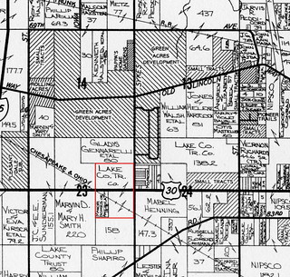
The 1950 Plat Book shows the farm still in its 1874 configuration, owned by J.C. and E.E. Sunderman. The 1972 Plat Book shows a change:

2022-02-12. Underwood-Sunderman 1972

Sometime after 1950, apparently, the Sundermans had sold the west half of their farm, and purchased another half-quarter-section north of U.S. 30.

By 1972, though, John Sunderman was gone; he had died January 31, 1967 (Indiana Death Certificates). And Ethel died on May 17, 1972.

In the summer of 1973, construction of Southlake Mall began.

2022-02-12. Valparaiso-Vidette-Messenger-Jun-06-1973-p-29
(Click on image to enlarge)
Vidette-Messenger, 6 June 1973.


_______________
[1] Possibly this Henry Wells? Early Land Sales, Lake County shows a whole lot of land purchased under that name.
[2] I have a story about him that we will get to some other time.
[3] "Merrillville," The Hammond Times, 28 Mar. 1940.
[4] "Hold Rites For Gary Highway Builder Today," Vidette-Messenger (Valparaiso, Ind.), 6 July 1935.
[5] "The Sunderman company is one of the largest road contracting firms in the state." "Contract Was Not Sub-Let," Lake County Times (Hammond, Ind.), 19 Aug. 1931.
[6] In the Occupation and Industry columns, the enumerator crossed out "laborer" and "steel mills" to substitute "contractor" and what looks like "house."

Wednesday, February 2, 2022

The Underwood and Other Schools

Some time back, I came across a reference to the Underwood school and had no idea where that school was.

Fortunately, Lenore Boyd Calpha prepared a little map showing the location of Ross Township schools, which has been preserved by the Merrillville-Ross Township Historical Society and is on display at their museum. Unfortunately, the markers on the map are so tiny that I couldn't read some of them behind the glass of the map's frame. Fortunately, one a recent visit to the museum I came across the map out of its frame and was able to scan it at a high enough resolution that I could blow it up on my computer screen and finally read most of the markers.

So here it is.

2022-02-02. Ross Township Schools
(Click on image to enlarge)
Image courtesy of the Merrillville-Ross Township Historical Society.


And there it is: #13, the Underwood school, on the northwest corner of the intersection of Mississippi Street and U.S. 30. Per the legend on the right, it was among Ross Township's one-room schoolhouses.

I am not 100% sure about the exact location, as the map is a little quirky: notice #17, the W.G. Hahn school — it's marked on the wrong side of S.R. 51. The Adams school, #7, is shown north of the Grand Trunk Railroad tracks where they cross Colorado Street, while the 1908 Plat Map shows the schoolhouse south of the tracks. The Underwood school is not marked on the 1908 Plat Map, nor is it clearly marked on the 1874 Plat Map, although the latter does seem to have the usual symbol for a schoolhouse (a solid square surrounded by a square outline, with or without "S.H.") in the same location as the Calpha map. At any rate, I think we can rely on the Calpha map for approximate locations.

By the way, the map is not dated, so we don't know what "Present" means in its title. But it refers to the museum building as the Merrillville Town Hall, so the map must have been made after 1971, and before Lenore Boyd Calpha's death in 1995.

Thursday, January 13, 2022

The Burge-Underwood House

The Merrillville/Ross Township Historical Society museum has a three-ring binder labeled "Places" that includes numerous photos of local homes, farm buildings, and businesses, some of them identified more or less clearly, some not at all. One of the projects on my "when I have some time" list is to research the locations of the originals.

Among them was this photo, which looks as if it had been taken in the late 20th century (as opposed to early 20th/late 19th).

2022-01-13. Burge-Underwood
(Click on image to enlarge)
Image courtesy of the Merrillville/Ross Township Historical Society.


I had this filed as "Burge-Underwood house," so of course when I started researching the history of the Willy family farm and came across both of those names, I started wondering what the connection was. And when I received a photo of the Willy house, which looks similar (with differences that could be explained by half-a-century's remodeling), I jumped to the conclusion that they were the same house.

I was wrong about that. Looking more closely at the notes on the back of the museum photo, I find a different location specified: "Burge-Underwood House / 73rd Ave — next to town hall / 1976 / the right view."[1] What was the town hall in 1976 is now the historical society museum.

However, the house is still connected to the farm on Colorado because both were occupied by the same family for a time. According to A Pictorial History of Merrillville, the 73rd-Avenue house was built in 1880 by Winfield Scott and Mary Jane (Demmon) Burge. They lived there until, according to the book, Mary inherited a farm from her father, Julius Demmon, who died in 1898.[2] That was probably the Colorado-Street farm; so when when the 1900 Census recorded them there, they hadn't been occupying it for long.

After the Burges left the house in this photo shortly before 1900, A Pictorial History skips over the next 20-some years, and then tells us that in the 1920s it was bought by Frank Underwood — hence the "Burge-Underwood" appellation. Frank lived there for some time with two of his sisters, Clara Underwood and the long-widowed Mary Castle. "Frank, a confirmed bachelor for many years, startled the community when, at the age of 60, he took Mrs. Nettie Macy as his bride." (Nettie, a widow, married Frank in 1933, in Kankakee County, Illinois.)

I came across this item about the house in a 1937 newspaper:

2022-01-13. Hammond Times, 25 Aug. 1937
(Click on image to enlarge)
Hammond Times, Hammond (Ind.), 25 Aug. 1937.


The 1940 Census records them still in the 73rd Avenue house, apparently. Frank died in 1956. My 1958 Merrillville directory shows Nettie still at 15 W. 73rd Avenue. She died in 1965.

That is all the specifics we can find in A Pictorial History: after the Underwoods, "[o]ver the years, the house was rented or owned by several families." When Jan Clemens was writing up the first edition of the book, which came out in 1976, the Burge-Underwood house was still standing. She mentions that it was then owned by the Town of Merrillville and its fate was uncertain. But its fate was decided soon, I imagine — perhaps before the book was actually printed, since the Merrillville Public Works Department building, which now stands on the site, was built in 1975 per the county records. The house probably had to be demolished to make way for it.

Here's the site as it looks now, from Google street view (2019):

2022-01-13. Former site of Burge-Underwood house - Google street view
(Click on image to enlarge)
Image from Google.com.


The first photo I posted above was taken from the west side of the house. The Historical Society has another taken from the east — a negative, but with photo editing software, easily enough turned positive:

2022-01-13. Underwood - positive
(Click on image to enlarge)
Image courtesy of the Merrillville/Ross Township Historical Society.


In the foreground you can see the sign pointing to the town hall parking lot and entrance. The house stood very close to the driveway of the town hall (now the museum).

I wonder if those are the same asbestos shingles from 1937?

_______________
[1] The "right view" in contrast to the wrong view, which we also have: I think it's the same photo but printed backwards.
[2] Julius Demmon does not appear as owner of the farm on any of the plat maps I have, but he have might been if only the farm had been included in the 1891 Plat book.

Friday, November 19, 2021

The Farm Under the Big Boxes

Standing at the intersection of U.S. 30 and Colorado street today and looking west, you see a vast expanse of asphalt surrounding big-box stores such as Sam's Club, Wal-Mart, and Home Depot, as well as restaurants and gas stations. Thousands of vehicles pass through the intersection, day and night. The parking lots are never empty. The lights never go out.

You can hardly imagine those hundred-plus acres as quiet farmland. You can hardly imagine U.S. 30 ending there, either; and yet all the maps we have show the road that is now U.S. 30 going no further east than Colorado, until the new Lincoln Highway came through in the mid-1930s.

I have been researching that area because the Merrillville-Ross Township Historical Society received an inquiry about the farm that once lay there — specifically, the farm of Frank and Catherine Willy, which comprised approximately 115 acres on the west side of Colorado Street, cut in half by the road that is now U.S. 30.

Here is my attempt to outline the Willy farm on the modern-day Google satellite view:

2021-11-19. Willy farm outlines, 2021 satellite view
(Click on image to enlarge)
Image from Google.com.


This farm, under various owners, had retained nearly the same dimensions for over a century. The earliest record I can find of it comes from the NWIGS' Early Land Sales, Lake County: on October 18, 1852, Harmon Underwood bought a total of 160 acres.[1] On January 11, 1854, those 160 acres became the property of John Underwood, who I believe was Harmon's son.[2]

Sometime between 1854 and circa 1874, the farm lost 40 acres on the west, as we can see on the 1874 Plat Map:

2021-11-19. 1874 Ross Twp. - future Willy farm
(Click on image to enlarge)

The new owner of those 40 acres, P.A. Banks, was probably Parley A. Banks. You can also see that H[armon?] Underwood owned another 200 acres east of the original farm.

And lastly, you can see that the mapmaker has clearly drawn a road from the west up to what is now Colorado Street, but eastward of that point, there is no trace of a road.

The 1891 Plat book does not include Section 23, so next we have to jump forward to 1908. Now we find the farm owned by Mary Burge.

2021-11-19. 1908 Ross Twp. - future Willy farm
(Click on image to enlarge)

We also find the parcel reduced in size by almost five acres, taken, I believe, by the Chicago, Cincinnati & Louisville (later Chesapeake & Ohio) Railroad, which began buying up right-of-way through Ross Township circa 1903.

My best guess as to the identity of Mary Burge is that she was a daughter of Julius and Nancy Demmon and married Winfield Scott Burge in 1878. The 1900 Census shows Winfield and Mary, with numerous children, living on their own farm in Ross Township in the general area of Colorado and U.S. 30 (to judge by their neighbors). Mary died in 1922. By the mid-1920s the farm had been sold: we find a new owner in the 1926 Plat Book.

2021-11-19. 1926 Ross Twp - future Willy farm
(Click on image to enlarge)

I cannot identify Caroline Schwer.

In 1932 the farm changed hands again. I will let the new owner tell the story of how that came about, as he told it to his descendants:
Three Ears of Corn

by Frank Anthony Willy

After Frank and Catherine were married, they moved onto a farm in Dyer, Indiana, which Frank rented from his father August. Besides charging rent, August required his son to hire his brothers to work the farm. This was a difficult situation at best for Frank and Catherine. During the Depression they had little money to spend and Frank's brothers were teenagers, with poor work ethics. Eventually Frank and Catherine realized that they could no longer afford to rent the farm in Dyer. They knew they would have to go out on their own and start a new life away from Frank's family.

Frank set out to visit three farms that were for sale nearby. The first was in Wisconsin. The ears of corn in the fields were large and well-formed and the house was well built with a natural spring underneath that could be used to keep food cold. This farm, he thought, would be an excellent choice.

The second farm he visited was in Illinois. Once again, the corn in the field was large, showing that the soil had been well taken care of. The outbuildings and home were also in excellent shape. He believed this would be a good farm to own.

Lastly, Frank visited a farm for sale in Indiana. This corn was just "nubbin."[3] The soil seemed to be spent, with most of the nutrients used long ago. The farm and its buildings were neglected and in very poor shape. As he took pictures of this farm he thought, "This is a very poor farm. It would be difficult to make a go of it here." As Frank returned to Catherine to tell her of his trip, his heart was heavy. He laid an ear of corn from each farm in front of her and then began to cry, for he knew the only farm they could afford was the neglected one in Indiana. And so it came to pass, that in 1932, Frank and Catherine Willy moved their family of eight and all they owned to the neglected Indiana farm with "nubbin" corn. Little did either of them realize what an excellent choice it would turn out to be.
(Story courtesy of Nick Hopman.)

Frank was then about 35 years old, Catherine (née Alber) about 32. They had been married in 1920.

Frank mentions taking photos of the farm when he first visited it. That may be the source of these two photos of the farmhouse and barn.

2021-11-19. 1932 Farmhouse in country
(Click on images to enlarge)
This and the following image courtesy of Nick Hopman.


2021-11-19. 1932 Farm in Crown Point 1932

Again, thanks to Nick Hopman, we have Frank Willy's own story about the early days on the farm, and what the construction of the new Lincoln Highway did for the family:
You kids first went to St. Peter and Paul's School. I had to drive you. But when I had no money to buy gas, I sent you to the Ainsworth school as the bus passed our house. The first day you came home you said you needed about $14.60 for books. Had to sell corn for $.12 a bushel. Had about $.60 over on that truckload. That shows you what the Great Depression was like. I did not sell any more, as Henry Bloom[4] said, "Don’t sell. I will go along with you if it takes ten years. I won't foreclose on the mortgage!" The mortgage was for $7,000. The next year we had the cinch bugs. Twenty acres of corn barely filled my little silo. The next year we had the great dust storm. Steady wind from the southwest. In Kansas the dust covered fences and buildings. People left their farms. We bit our lips and held on.

Had 12 acres of fine wheat. Wanted to cut it on Monday. Henry Bloom was out on Saturday. "You ought to cut it. Sometimes it don't pay to wait 'til it has fully ripe." Sunday night it hailed. Shocked everything flat. Holes in the tarpaper roofs. Cut off branches of trees. It was a quarter-inch thick on the ground. I raked the wheat field and got Hank Homeier[5] to come and thrash it. Blew the straw into the barn and got 60 bushels of wheat. I needed that straw. Also paid Koehler[6] $10 so I could cut some slough grass, and Old Nick (our hired hand) herded the cattle there. In 1934 the new highway (US 30-the Lincoln Highway) came through. Then I had it made. When US 30 road work was being done I rented a small area to the state for material storage. When the work was done, instead of having the state clean up the storage area by removing the remaining sand, gravel, and steel, I negotiated to do it myself, for a price of course. But instead of cleaning up the mess, I just sold the materials until they were gone.
For some reason, the 1939 Plat Book fails to show the new highway east of Colorado:

2021-11-19. 1939 Ross Twp - Willy farm
(Click on image to enlarge)

But the 1939 aerial view shows it clearly:

2021-11-19. Aerial photo 1939 Willy Farm (LakeBFJ-04-043)
(Click on image to enlarge)
Image from https://igws.indiana.edu/IHAPI/Map/.


This raises the question whether the 1874 cartographer just made a mistake about the road extending east of Colorado, and that mistake was perpetuated by subsequent map-makers who didn't bother to investigate for themselves. But I am going to ignore that possibility because it's just no fun at all.

Anyway, the 1950 Plat Book shows the new U.S. 30:

2021-11-19. 1950 Ross Twp. - Willy farm
(Click on image to enlarge)


As you can see from the 1939 aerial view above, the Willys' house and farm buildings stood on the west side of Colorado Street, north of U.S. 30. This photograph shows more clearly how the buildings were arranged in relation to Colorado Street, which runs diagonally across the bottom of the photo:

2021-11-19. Willy farm, Crown Point mail address
Image courtesy of Nick Hopman.


Frank and Catherine Willy farmed that land for 30 years, through the Great Depression, through World War II, and beyond. Their children grew up, moved out, started families of their own. Frank and Catherine bought a modern ranch house in the Green Acres neighborhood. In 1962, they sold their farm.

Here is the former Willy farm as it appears in the 1972 Plat Book:

2021-11-19. 1972 Ross Twp. - former Willy farm
(Click on image to enlarge)

The new owner probably rented most of the land to locals who were still in the farming business.

This 1978 aerial view from the Lake County GIS website shows that the farmhouse and outbuildings have been removed, and some kind of business is operating in the northwest corner of the U.S. 30/Colorado intersection:

2021-11-19. 1978 aerial view (Lake County IN GIS)
(Click on image to enlarge)

The 1990s brought the era of the big-box store, and the landscape of the old farm was utterly transformed.


_______________
[1] He bought the south half of the northeast quarter, and the north half of the southeast quarter.
[2] Cf. Lake County Encyclopedia, p. 80. I'm a bit confused.
[3] "Nubbin" — a small or imperfect ear of corn [per the author].
[4] We don't know for certain who Henry Bloom was. My best guess is Henry Blume (1867-1958), who shows up in the 1910 Census farming his own land in Center Township, but in all subsequent censuses he gives no occupation. He and his wife, Mary, had only one child, who died in 1920.
[5] I think this was Henry Homeier, who farmed northeast of Merrillville.
[6] I give up.


Friday, January 11, 2019

"Hickory Grove" and Other Mysterious Places

In August of 1874, Hobart's Union Sunday School made plans for its annual picnic. The date was set for Thursday, September 3. The organization's secretary, John Blackhall, wrote to neighboring Sunday schools inviting them to join in the fun. Two of them accepted the invitation: the Underwood school and the Hickory Grove school.

2019-01-11. USUN1873B 092, 093
(Click on image to enlarge)
Image courtesy of the Hobart Historical Society.


I have come across the Underwood name before. There was a one-room schoolhouse by that name in Ross Township, exact location unknown, which may have been associated with a Sunday school as well. But in all my research, I have never come across the name Hickory Grove in this area. Was that a mistake for Hickory Top — the village that eventually became Ainsworth? And then again, was it actually a mistake? Perhaps some people called the village Hickory Grove, while others called it Hickory Top, and somehow the former was overshadowed by the latter in collective memory.

That's just a theory. You know how I love theories.

Anyway, it sounds as if the picnic went off well. The Hobart Cornet Band came along to provide music. The attendees rode in two excursion cars — on the Pennsy Railroad, I'm guessing, since during the planning stages the location was set for Robertsdale, which got its name from George Roberts' giving the Pennsy Railroad right of way through his land.[1] But below the reference to Hickory Grove on the page above, the writer gives "Sheffield" as the location of the picnic. Perhaps those were pretty much the same place. These days you can find Robertsdale on Google maps, but not Sheffield. We do find Sheffield on this section of the 1874 Plat Map showing the west end of North Township:

2019-01-11. Sheffield 1874
(Click on image to enlarge)
Image courtesy of the Merrillville-Ross Township Historical Society.


At the eastern border of Sheffield, we find a parcel of land belonging to George Roberts, with the Pennsy Railroad (the southernmost of those three lines) crossing it. Further to the southeast lay another George Roberts, also crossed by the Pennsy Railroad. I don't know which of those gave Robertsdale its name — maybe both?

But all of that area is in Hammond now, and this is as far as I intend to go into Hammond history.

_______________
[1] Gayle Faulkner Kosalko, "Robertsdale has a history all its own," April 3, 2008, NWI Times, https://www.nwitimes.com/news/local/robertsdale-has-history-all-its-own/article_df6cf958-2db8-540f-aff0-8f3ea0fe5f81.html

Thursday, December 27, 2012

A Hodgepodge of Tidbits

A few news items that for some reason I thought needed to be in this blog, dating to mid-March 1920.

Deering, Shearer, Raschka, Chester news
(Click on images to enlarge)

When I saw that item about Gust Deering moving onto an Ainsworth-area farm, I thought I had never heard of him. But upon perusing my notes, I see he's figured in them twice before (though I never mentioned him in the blog), and both times because he was moving, or thinking of moving, to another farm, i.e., in January 1910:
Gust Deering who lives on the Kruse farm east of Ainsworth has rented the Wm. Bissell farm five miles east of Crown Point and will move sometime next month. We understand that James Ed Kelly who formerly lived on the Kruse farm will again occupy the place as soon as Mr. Dearing [sic] moves.
and in February 1920:
Gust Deering and family are preparing to move on to the Nightingale farm, [microfilm illegible but I think it says: formerly known as the Zeller] place containing 220 acres, located southwest of Ainsworth. They have resided on the Clinton farm for the past five years, but this farm was sold last year to D.C. Frank. Mr. Deering thought some of quitting farming, and last year bought the Thos. Hanna home in Joryville, but when his son Henry returned from the war and concluded to stay with his father on the farm, Mr. Deering thought it best to continue farming. Their other son William, is employed this winter in Gary.
So at this point I don't know anything about Gust except that he keeps changing his mind.

As for what was formerly known as the Underwood farm, if we go back to 1874 we find several parcels owned by various people with that surname, but the one directly north of the Vincent schoolhouse comprised 240 acres on the west side of Clay Street.

Old Underwood farm?

Concerning Lesta (not "Tesla") Raschka and her visit to Michael Reese Hospital in Chicago, the News attributed her health problems to an attack of "infantile paralysis several years ago."

"Mr. Chester" is, of course, Charles Chester.


Sources:
♦ 1874 Plat Map.
♦ "Local and Personal." Hobart News 5 Feb. 1920; 18 Mar. 1920.
♦ "Local Drifts." Hobart Gazette 14 Jan. 1910; 19 Mar. 1920.