Showing posts with label Ghearart. Show all posts

Saturday, November 14, 2009

Ainsworth Road = Indian Trail? Part 2

In a previous post, I quoted an affidavit by a long-time Ainsworth resident, Willim Homer Ghearart, which seemed to me to say that Ainsworth Road had started its life as an Indian trail. I said that a map printed in Kenneth J. Schoon's Calumet Beginnings appeared to back up my conclusion.

This morning I got ahold of some free software (Paint.net) that allows me to layer pictures. I took part of the "Indian Trails and Villages" map from Calumet Beginnings and layered it with the corresponding part of a 1990 Rand-McNally road map I have lying around.
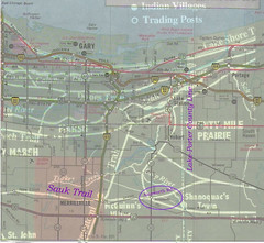
Sauk Trail Ainsworth Rd comparison
(Click on image to enlarge)

I tried to align them on two assumptions: that the Lake-Porter county line was the same in both, and that Old Lincoln Highway and the Sauk Trail should correspond in the area of Merrillville. The heavy white lines are the Indian trails from Schoon's map. The Rand-McNally road markings are finer lines. My notes are in purple.

With that alignment, the part of the trail branching off from the Sauk Trail, crossing Deep River and then the county line, does correspond pretty well with Ainsworth Road.

On the other hand, the Lake Michigan shorelines don't line up, so perhaps I've made a mistake.

On the third hand, this blog is not a scholarly work, and I'm glad of that — it means I don't have to get my footnotes right (although I do sometimes make a half-hearted attempt to follow MLA format). It means I can engage in wild speculation, and build theoretical castles on the flimsiest of evidential foundations. And for my purposes today, it means I can disregard the mismatched shorelines, declare myself satisfied, and henceforward go around telling everybody that Ainsworth Road used to be an Indian trail.

Friday, October 23, 2009

Affidavit of William Homer Ghearart, April 12, 1930

William Homer Ghearart being first duly sworn upon his oath deposes and says that he is aged eighty-four years and has been a resident of Porter County, Indiana, since 1850, and was well acquainted with Henry T. Smith, grantee in a warranty deed dated December __, 1857 [sic], conveying the West One Half (1/2) of the Northwest Quarter (1/4) of Section Seventeen (17), Township Thirty-five (35), Range Seven (7) West, containing eighty acres of land . . . .

Affiant further says that Henry T. Smith was an aged man at the time and had been to California in 1849; that said Henry T. Smith died about 1858 and that he left surviving him as his sole and only heirs at law Sarah Smith, his widow, Burnette T. Smith, a son, Mary Smith, a daughter, Hodson T. Smith, a son, and Alfred T. Smith, a son; that the sole and only heirs at law of Henry T. Smith gave a quit claim deed to the above described property to Charles Chester, dated December 19, 1858 . . . .

*   *   *
That the road running in an easterly and westerly direction through the north end of said land was at one time called the old Sac trail, and has been in the same location as long as this affiant can remember.

That this affiant knew of Lucy M. Hanks, who was the sister of the wife of Henry Chester in 1867. That Lucy M. Hanks married a man by the name of Spencer, but April 6, 1867, she was a single woman.
The road he describes in the third paragraph as the old Sac trail (I’ve more commonly seen it spelled “Sauk”) sounds very much like Ainsworth Road. I’ve always wondered why Ainsworth Road was laid out so oddly, at a not-quite-45-degree angle to the more orderly north-south roads it crosses. Its being an old Indian trail would explain that.

In Calumet Beginnings, Kenneth Schoon provides a map of Indian trails in northwest Indiana. He states that the Sauk Trail was chosen as the route for the Lincoln Highway when it was being built in the early part of the 20th century. The map he provides shows the main Sauk Trail roughly corresponding to the Lincoln Highway, aka 73rd Street in the vicinity of Ainsworth, but it also shows a short path branching off from the Sauk Trail a couple miles west of the Lake-Porter county line, moving northeast, crossing Deep River north of Shanoquac’s Town, and joining up in Porter County with another path labeled “To Tassinong and Potawatomi Ford.” Part of this short path resembles Ainsworth Road.

Sources:
♦ Ghearart, William Homer. Affidavit. April 12, 1930. Filed for record in Lake County, Indiana, July 7, 1930.
♦ Schoon, Kenneth J. Calumet Beginnings: Ancient Shorelines and Settlements at the South End of Lake Michigan. Bloomington: Indiana University Press, 2003.