
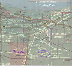
This morning I got ahold of some free software (Paint.net) that allows me to layer pictures. I took part of the "Indian Trails and Villages" map from Calumet Beginnings and layered it with the corresponding part of a 1990 Rand-McNally road map I have lying around.
(Click on image to enlarge)
I tried to align them on two assumptions: that the Lake-Porter county line was the same in both, and that Old Lincoln Highway and the Sauk Trail should correspond in the area of Merrillville. The heavy white lines are the Indian trails from Schoon's map. The Rand-McNally road markings are finer lines. My notes are in purple.
With that alignment, the part of the trail branching off from the Sauk Trail, crossing Deep River and then the county line, does correspond pretty well with Ainsworth Road.
On the other hand, the Lake Michigan shorelines don't line up, so perhaps I've made a mistake.
On the third hand, this blog is not a scholarly work, and I'm glad of that — it means I don't have to get my footnotes right (although I do sometimes make a half-hearted attempt to follow MLA format). It means I can engage in wild speculation, and build theoretical castles on the flimsiest of evidential foundations. And for my purposes today, it means I can disregard the mismatched shorelines, declare myself satisfied, and henceforward go around telling everybody that Ainsworth Road used to be an Indian trail.


No comments:
Post a Comment