On the left side of the sheet, she notes that it represents the north side of State Road #30 (i.e., the Lincoln Highway). She notes that while the entire sheet is devoted to State Road #30, only the first 17 lines represent Deep River households.
The theory that she is moving west from Deep River, along the north side of State Road #30, is supported by the 1939 plat map of the Ainsworth area. On the census schedule, we find the Hallowell, Baessler and Eason households owning land; looking at the 1939 plat map, we find those same landowners, in that same order, east to west on the north side of State Road #30.
The next name we encounter on the census sheet that matches the 1939 plat map is Hurlburt. We've already met Jacob and Augusta Hurlburt, and we know they owned land on the northeast corner of the intersection of Grand Boulevard and the Old Lincoln Highway.
Continuing west, Mrs. Fredrick records two renters who wouldn't show up on any plat book, and then the Chester household, operating a tourist camp.
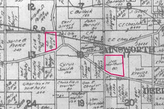
West of the Chesters, there are two more renters. The next landowner listed is Albion D. Paine. We've now moved out of Range 7 into Range 8 and my copy of the 1939 plat book seems to be missing the relevant page, so we have to go to the Plat Books of Indiana Counties of uncertain date, estimated on the IUPUI website to be between 1925 and 1941, in order to find Mr. Paine. Here is an excerpt from the undated plat book, showing the Hurlburt and Paine land outlined in pink:

(Click on image to enlarge)
So Chester's Camp is west of the Hurlburts and east of the Paines (assuming the land ownership has not varied greatly between the plat book and the census), on the north side of the street.
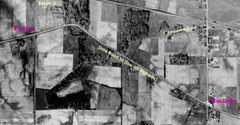
Here's an aerial view of the area, with the Hurlburt and Paine land holdings marked.

(Click on image to enlarge)
I can't determine where Chester's Camp was using the aerial photos for two reasons. First, when you enlarge them to try to see things at ground level, they become so fuzzy as to be almost useless unless you already know what should be there and you're just trying to confirm it. Secondly, I don't know what should be there. We've already learned that John Chester left this location in 1935, moving his tourist camp operations to the vicinity of Tremont. What became of this Chester's Camp after 1935, whether any part of it was still standing in 1939, and, most importantly, what its layout was, what I should expect to see from the air — I simply don't know.
Still to come: newspaper testimony about the location of Chester's Camp.
Sources:
♦ Ancestry.com. 1930 United States Federal Census [database on-line]. Provo, UT, USA: Ancestry.com Operations Inc, 2002. Original data: United States of America, Bureau of the Census. Fifteenth Census of the United States, 1930. Washington, D.C.: National Archives and Records Administration, 1930. T626, 2,667 rolls.
♦ Lake County Title Co. Plat Book of Lake County 1939. n.p., n.p., n.d. Print.
♦ Plat Books of Indiana Counties, Vol. 3, p. 253. Lombard: Sidwell Studios, n.d. IUPUI University Library Program of Digital Scholarship. Historic Indiana Plat Books. Indiana University-Purdue University Indiana. 16 Nov. 2009


No comments:
Post a Comment