
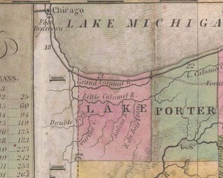
(Click to enlarge)
This map comes, via the U. of Alabama website, from J.H. Young, The Tourist's Pocket Map of the State of Indiana, Exhibiting its Internal Improvements, Road Distances, etc. (Philadelphia, S. Augustus Mitchell, 1837).
The map shows Lake County as a vast emptiness containing only rivers, but Lake County was formally organized February 15, 1837. There were hundreds of people living in the county, and Crown Point, for example, was settled in 1835. These may have been squatters on government-owned land; perhaps that was Mr. Young's problem, or maybe he just ran short of ink.
On this map Lake County's southern boundary is not, as at present, the Kankakee River.
Over the counties south of Lake appears the legend "Country Ceded by the Pottawatomies."
I have nothing further to say. You're lucky I said this much. This is one of those days where all I want to do is sleep.


No comments:
Post a Comment