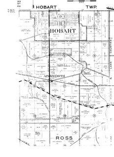
(Click on image to enlarge)
From Lake County Title Co., Plat Book of Lake County 1939.
I attended an auction this morning, just down Ainsworth Road (8842, to be exact). I hadn't been to an auction since I was 18 years old, when my mother and I bought a rocking chair at an estate sale in Munster, Indiana.
Today I bid on only one thing, the plat book extracted above. There were other things that interested me — the 1949 telephone directory, for example — but I did not bid on them. I feel like an alcoholic who has stopped at one drink!
Here, then, is who owned where in Ainsworth in 1939; or least, that's what it purports to be. I just have one question: where is (the present-day) Route 30? It's clear enough on those 1939 aerial photos.
Also: what's with that "Watershed Line" south of Lincoln Highway? This is not something I can say I've ever noticed in the landscape in my 19 years here, and yet the mapmaker seems to be perfectly sure of it.
Leaving aside those questions, I'm looking at the property where my house stands now (and stood then) and seeing a name I didn't expect.
According to the key in the upper right that my scanner cut off, Ainsworth Road was a gravel road at this time.
There is no key to tell me what is meant by that dotted circle by the name "Ainsworth," nor that smaller black circle on the southeast side of the dotted one.
Interesting, huh? That's $30 down the drain.


No comments:
Post a Comment