
(Click on images to enlarge)
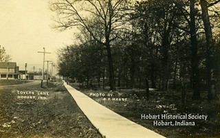
Top image courtesy of the Hobart Historical Society.
The first image comes from the files of the Hobart Historical Society. It's on a postcard with no postmark, but since it has a divided back, it should be 1907 or later. On the other hand, you can't see anything in the photo resembling the Strattan house scenery superstructure, which was added in 1907. So perhaps the photo itself was taken earlier, and some time elapsed before it was put on a postcard.
The actual location is something of a mystery. On the back of the postcard are anonymous notes saying that this photo was taken from a spot across from the (present-day) Dairy Queen, and the writer even drew a little "you-are-here" map to clarify the location, showing Main Street, the railroad tracks and downtown Hobart. And looking at the photo, yes, we can see the crossing sign at the Norfolk Southern-Main Street crossing, and far in the distance, between two telephone poles, we can see the spire of Trinity Lutheran Church, at the corner of Main and Second. But it can't be — where is the Unitarian Church? We ought to be able to see it. It may be behind the trees, but we should at least see its steeple rising above the treetops at the middle or right of the picture.
I suppose it's possible that some conspiracy of the trees and the film exposure makes the church impossible to distinguish among the branches and the sky. I don't know.


No comments:
Post a Comment