Two items from the "All kinds of Wants" column in the
Hobart Gazette of Sept. 8, 1922:
FOR RENT — My farm of 100 acres, on Lincoln Highway, south of Ainsworth. Julius Triebess, 6936 Michigan avenue, Chicago.
FOR SALE — My house, barn and acre tract at Fatout, south of old Deepriver schoolhouse, on C.&I. railroad. Otis Guernsey, Route 2, Crown Point.
I've been unsure about
who, if anyone, has been renting the
Triebess farm; I hope one of the papers will report on its new tenant.
That second item has taken up 'way more of my time than it should have. We know that Otis Guernsey's farm lay northeast of where
Randolph Street crosses the C&O Railroad. When Harold Guernsey died in 1921, his obituary used the name
"Putout" — which I believe to be a simple typographical error, since my notes from 1916 carry the first mention of "Fatout":
Delbert Young has moved into the new house which he has built on the road leading south of the Deepriver schoolhouse past "Fatout," the new railroad station. His new house and barn look fine.*
And now in 1922 we see it spelled "Fatout" again. Majority wins. But Google, which knows about
everything, doesn't know about the village or railroad station called Fatout.**
And what about the railroad where Otis' property lay? Is "C.&I." a typo for "C.&O."? The C&O railroad has had several names, but I can't confirm that "C.&I." was among them. There was a
railroad in Pennsylvania with those initials, which I didn't want to know but had to spend the time finding out because of this stupid little want ad. Is it any wonder I can't get anything done?
Well, if you want my theory on all this, here it is: the C&
O Railroad built a new station circa 1916, probably about where Randolph crosses the tracks, called it Fatout after one of its bigwigs, but — in contrast to how thoroughly the station name "Ainsworth" was adopted — the name never really took hold among the locals and was forgotten until I came along nosing around in the old microfilm.
♦ ♦ ♦
Another mystifying item from the "Local Drifts" of the
Hobart Gazette of Sept. 1, 1922:
H.F. Carey, who recently moved upon his farm, has rented his house and five acres south of 10th street to Mr. and Mrs. Wm. Bracken, who have leased the place for 14 months, and moved yesterday.
I don't know where the Carey house was. I used to think it was one of the older ones on the north side of 10th but according to this news item it was the south side. Or was just the five acres on the south side?
The item goes on to say that Mr. and Mrs. Howard Bracken would continue to occupy the Bracken place, moving into the big house from the small house. I gather that Mr. and Mrs. William Bracken are the parents of Howard. William was born on that farm and when he married, he and his wife took up housekeeping there, so this was the first time he'd ever lived off the old Bracken place. But the Bracken milk route — William's, I'm assuming, though it's not clear — would continue without interruption.
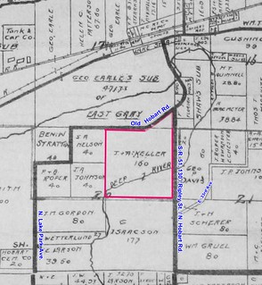
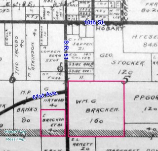 (Click on image to enlarge)
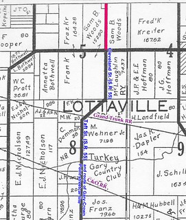
Bracken land as shown on the 1908 Plat Map. The 1926 Plat Book shows the parcel on the west side of S.R. 51 belonging to someone else.
_______________
*"Additional Local News,"
Hobart Gazette 30 June 1916.
**It doesn't help that there was a Purdue U. professor named Paul Fatout who wrote about historical topics and whose name clogs up the Google searches.