
(Click on image to enlarge)
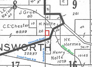
The 1926 Plat Book still marked off Gilbert Bullock's ten-acre parcel, even though by then Henry Nolte, Jr. had owned it for ten years.
Henry Jr. must have been doing fairly well if he could muster $1,000 (about $20,000 in today's dollars) to buy that parcel.
Having spoken with a former neighbor of Henry and Louis Nolte, I can say that my estimation of the Nolte family, or at least of these two, was probably correct. I say "probably" only because this neighbor was so much younger than Henry and Louis that they could not have been close friends. He remembers them as quiet and hardworking people; good neighbors and pleasant enough in their mild way, but definitely not the lively, fun-loving types that their cousins the Harmses were.
The two brothers called each other "Hen" and "Lou." Henry was tall and slender, Louis a little shorter and heavier. By the late '20s or early '30s, each had his own car, both Fords, a Model A and a Model T. They kept the cars in an outbuilding of Hobart terra cotta block. I've come across broken terra cotta among the trees east of Big Maple Lake; I wonder if it's the remains of that building. Yes, it turns out I guessed correctly about where their house was — on the north side of Ainsworth Road between the Deep River and present-day Big Maple Lake.
The family had planted pear trees on the slope down to the Deep River bottoms, and the neighborhood kids used to go eat their pears. The kids knew the location of every good fruit tree in the neighborhood.
Sources:
♦ 1874 Plat Map.
♦ 1891 Plat Book.
♦ 1926 Plat Book.
♦ CPI Inflation Calculator.
♦ "Hobart Real Estate Transfers." Hobart Gazette 5 May 1916.


No comments:
Post a Comment