
(Click on image to enlarge)
"Mr. Colburn" was, I believe, the 64-year-old Zerah Colburn, who had come to the Hobart area circa 1843 with his parents (Early Land Sales, Lake County) and lived out the rest of his life here. For Cruther I think we should read Carothers — and we have already mentioned that family in connection with the bridge on the tumbling dam. The young man who died in 1854 must have been John Carothers, Jr.; at that time he would have been about 17 years old.
I have found no follow-up story in later issues of the newspaper, so it is possible that young John's bones still lie in that box along the route of the vanished J spur.
We know the route:
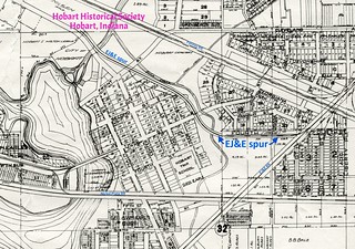
(Click on image to enlarge)
Image courtesy of the Hobart Historical Society.
The spur actually extended as far as the western Kulage brickyard (see 1902 Sanborn map), which I find interesting because that part of the brickyards was on land once owned by the Carothers family. The image below shows that area as it appears on the 1874 Plat Map, with the east half of the southeast quarter of Section 30 owned by "Crothers." In 1846 John Carothers, Sr. had bought the parcel outlined in green, and in 1851 the parcel outlined in red (Early Land Sales, Lake County). He must have sold the green parcel before 1874.
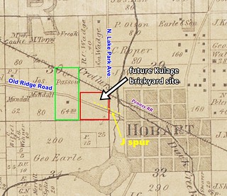
(Click on image to enlarge)
However, I doubt that young John's bones lie in that land. Zerah Colburn said John was "buried upon his … father's lot" — which sounds like a (relatively) small lot in town. In further support of this theory, the "Heitmann place" was likely in town, if we assume it was one of the two Heidtmann households shown in the 1900 Census. That census records one household composed of Fred and Liddie Heidtmann and their children, and a separate household where Fred's mother, Sophia, lived with her own elderly mother and an unmarried son. Both homes were within "Hobart Town," but I don't know the exact location of either. The one that included Sophia was probably on Michigan Avenue: it was described that way when Sophia died in 1909[1], and its being recorded in the 1900 Census next to the Melin home (northeast corner of Michigan and Cleveland) suggests they were neighbors. However, even if that Heidtmann place was on the west side of Michigan Avenue — with a railroad track and a creek between it and the J spur's route, to call the excavation "below the Heitmann place" seems a bit of a stretch.
It's odd that Zerah Colburn would say that in 1854 Hobart had no cemetery. I suppose he meant no cemetery within the village. Zerah's own parents are buried in the Old Settlers Cemetery, and both died before John Carothers, Jr.: his father, Allen, in 1843, and his mother, Maria, in 1851. Still, in 1854, small family burial grounds on private property were not so very unusual, although I would expect such grounds to be more rural — a burial in a town lot would be out of the ordinary.
_______________
[1] "Old Citizen Dies," Hobart Gazette, May 14, 1909.


5 comments:
I am so intrigued by this information!! In the late 1950's my cousins lived @ 215 New St which was adjacent to the Ols property which faced 3rd St. Next north lived Moody's, and there the street dead ended. In back of 215 was a large "barn" like structure, much older than the house. The slope behind the barn led down to the old spur line. And on this slope I remember there were gravestones. There were at least 2. I want to say one of the names was Mary, not sure. Having an overly active imagination we used to pretend they had died on their way west in a wagon train. I vividly remember the graves being there, but my cousin doesn't! There is no one left from our parent's generation to ask about it. I have inquired of some locals also but no one was aware of this. And now this old (new!!) info!! The 215 house, two story, with apartments on the 1st floor, was built late 40's early 50's by my cousin's granddad, surname Bauer and corresponds roughly to lots 86 and 87 on your plat map. Denny Nelson's cousin owns, or used to own the house where the Moody house stood. I told K. Nelson we needed to go knock on a couple doors on that St. just to do a little historical research. It would be nice to know the stones are still there and that they are undisturbed. It would be great to find out more about this!
Well, now, isn't that interesting!!!
From the Ols house to Mellon house is the only place that could be where the spur could be "below".
The bank of Duck Creek is much wider at the west, so any exacavation done was behind that short dead end section of New St.
Still seems odd with the Hobart cemetery only 500 feet away across the creek. Do we know what year it was established?
The gate in front of Hobart Cemetery says "1859" -- I'm guessing that's the date it was established.
The first map shows a hand drawn elevation line between 3rd St and Front St.
At the end of New St, the curved line the spur line crosses describes a hillside point that had to be knocked down maybe 10 to 20 feet. Glad someone saved that map with that topographic line.
Post a Comment