Monday, August 31, 2009

Farmer Wiring Again

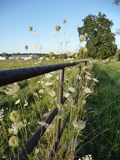
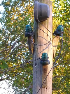
... but this time it's not dangerous, just picturesque. There's a single telephone pole close to the barn with old glass insulators and the remnants of wires that used to run between the house and the barn. The wires are long broken and gone; the barn is no longer electrified.

Farmer Wiring
(Click on images to enlarge)

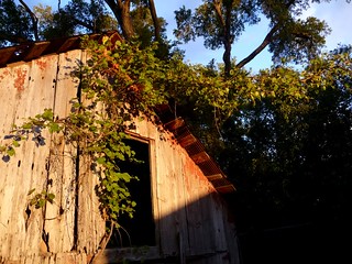
Speaking of the barn, it's so decrepit as to be largely useless, but it's very pretty, in the early evening sunlight, with that wild grapevine growing over it:

Old Barn Grapevine

It was never much of a barn. Even when it was brand new, it couldn't have sheltered more than three or four cows, mules, horses or whatever they kept in there, with a small loft for storage. Here's a hinge on the big door (which was usable when I first moved out here, but that was a long time ago and the hinges are rusted shut now):

Hinge on Old Barn

* * *

I spent a lot of time these past couple of days trying to upload photos to Flickr. It seems to be a very popular site, and more vibrant than Photobucket in terms of communities and discussions among users, but dang! — about 80% of my upload attempts fail, after a long wait. Does Flickr not like dial-up, or what? I think I shall have to stick with Photobucket; I just don't have the time or the high-speed connection.

Sunday, August 30, 2009

An Ainsworth Rainbow

P1000231
(Click on image to enlarge)

If I didn't have insomnia, I wouldn't have been awake at dawn on a Sunday morning to see this double rainbow.

Sorry about the raindrops on the camera lens.

Saturday, August 29, 2009

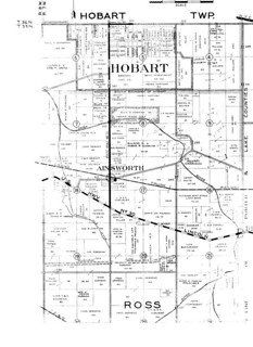
Plat Book 1939: Ainsworth

1939platbook
(Click on image to enlarge)

From Lake County Title Co., Plat Book of Lake County 1939.

I attended an auction this morning, just down Ainsworth Road (8842, to be exact). I hadn't been to an auction since I was 18 years old, when my mother and I bought a rocking chair at an estate sale in Munster, Indiana.

Today I bid on only one thing, the plat book extracted above. There were other things that interested me — the 1949 telephone directory, for example — but I did not bid on them. I feel like an alcoholic who has stopped at one drink!

Here, then, is who owned where in Ainsworth in 1939; or least, that's what it purports to be. I just have one question: where is (the present-day) Route 30? It's clear enough on those 1939 aerial photos.

Also: what's with that "Watershed Line" south of Lincoln Highway? This is not something I can say I've ever noticed in the landscape in my 19 years here, and yet the mapmaker seems to be perfectly sure of it.

Leaving aside those questions, I'm looking at the property where my house stands now (and stood then) and seeing a name I didn't expect.

According to the key in the upper right that my scanner cut off, Ainsworth Road was a gravel road at this time.

There is no key to tell me what is meant by that dotted circle by the name "Ainsworth," nor that smaller black circle on the southeast side of the dotted one.

Interesting, huh? That's $30 down the drain.

Friday, August 28, 2009

Wildflowers of Ainsworth: Maximilian Sunflowers

What's a day without pictures?

Q.: What happens when you have a new digital camera that you don't quite know how to use, and you go out on a windy, rainy day and try to photograph Maximilian Sunflowers?

A.: You get an artsy-fartsy picture like this:

P1000188
(Click on images to enlarge)


Here's what Maximilian Sunflowers look like when they're standing still.

P1000218

Farmer Wiring: An Electrifying Encounter

Soon after I moved to this house, I called a plumber in to look at my dying sump pump.

"There's some other things around here that could probably use some work," I said.

He walked around the basement, looking the plumbing up and down, shaking his head. He paused before the water softener, glanced over its connections and muttered, "Well, that's not up to code." He walked over to the corner by the sump and stood, hands on hips, examining the jerry-rigged shower: two walls of plywood which, with the basement walls, formed a narrow box; ragged plastic curtain; shower head and handles shakily clinging to the concrete-block wall; drainage provided by a short channel gouged into the cement floor and leading directly into the sump.

"This," said the plumber, "is what we call farmer plumbing."

Yesterday I had an encounter with farmer wiring.

It began when the plumbers (new ones; old one retired) were finishing up, and one of them, Dave, called me down to the basement. He said, "You ought to do something about this thing." This thing was a length of conduit hanging from the side of a live ceiling outlet; inside the conduit were two wires that stuck out at its loose end, capped off. The whole mess had been resting comfortably atop the water softener, but since the plumbers had just taken the water softener away forever, the capped wires now rested on the floor. Dave went on: "You could fry yourself if the basement floods. You'd never know until you stepped into the water." He found a nail in a joist and hooked the conduit over it to hold it up, precariously, near the ceiling.

"Yeah," I said, "I've been meaning to take care of that for the last ten or twelve years."

So yesterday, since it was raining steadily and I couldn't work outside, I decided to "take care of" it.

Now, I don't know much about electricity, but hey, logic + experimentation = new wiring, right? It's worked for me in the past. I don't do complicated double-switch wiring, but I've managed to install dusk-to-dawn lights by the back door and on the garage, and an outlet in the front porch.

I plugged my vacuum into the ceiling outlet in question and turned it on, then I went to the breaker box and started flipping breakers until the vacuum shut off. Breaker #6, hm? Flipped that breaker back — vacuum goes back on — flip again, vacuum shuts down. Got it. Vacuum not running = no current to the outlet.

You'd think so, wouldn't you? You'd really think so. I thought so.

Rather than try to work with that big hunk of conduit dangling and banging around, I decided to cut its wires just outside the outlet, then open the outlet and remove the wire remnants. Out of the toolbox I took my rubber-handled wire cutters, the ones with the rubber handles. By the way, they have rubber handles. Did I mention they have rubber handles? Thank God they have rubber handles.

I fitted the cutter blades over the wires and squeezed.

A flash of light — a loud POP! — the next sound was the wire cutters hitting the floor; and the next sound was me saying some very, very naughty words.

I never felt a thing. Thank God for those rubber handles.

I climbed down from the (plastic-stepped) footladder, composed myself, went over to the breaker box and flipped every gosh-darn breaker for the entire house, and completed my work in dimness and silence.

Probably any electrician would have known to test those capped wires somehow first, but I'd rather blame "farmer wiring" than my own ignorance for nearly electrocuting myself.
Thursday, August 27, 2009

Queen Anne's Lace

P1000204
(Click on image to enlarge)

Also known as wild carrot. Delicate, lacy and prolific.

* * *

My computer is more than usually sluggish this morning. For that matter, so am I. It's a rainy, cold and gloomy morning; I've been up since 4:00 a.m. because I suffer from chronic insomnia. In other words — not much to say.

Wednesday, August 26, 2009

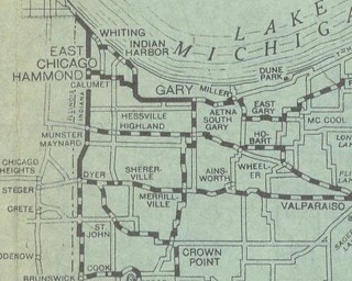
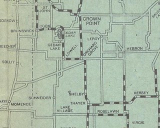
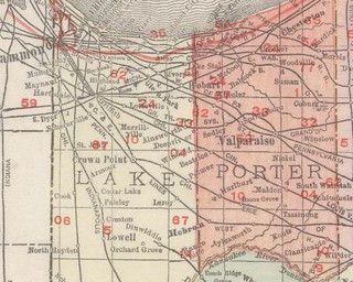
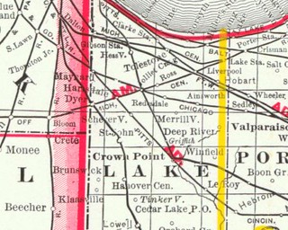
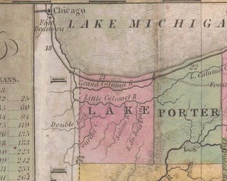
Lake County 1920

Northern Lake County

1920LakeCountynorthern

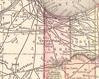
Southern Lake County

1920LakeCountysouthern

From Goodrich Travel and Transport Bureau - B.F.G.R. Company, Goodrich Road Map of Indiana (Akron, Ohio: Beck Raymond Commercial Print and Lithograph Company, c.1920), via the University of Alabama.

This map is disorienting. Ainsworth rates the same size typeface as Merrillville and Hobart. Grand Boulevard appears to have a significant east-west jog in it. The greater part of Ainsworth Road has simply disappeared.

But don't you just love the way the whole thing looks? Doesn't the whole style just say "1920s"?

Here endeth my University of Alabama adventure. The last Indiana map they have, 1940, is some kind of topographical or geological thing and not pertinent to this blog. Great site, though, and I am much obliged to the Alabamians.

Tuesday, August 25, 2009

Nature on an August Afternoon

Things I saw while working in my yard this afternoon. (Click on images to enlarge.)

P1000208
Butterfly drinking nectar from a wildflower, which I can't identify because I haven't received my wildflower identification guide yet.


P1000211
Dragonfly sunning itself on a dead branch.


P1000214
Giant mutant wasps Hornets drinking sap from the cut in a girdled elm.


P1000205
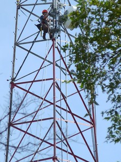
Tower-climbing primate. My initial impression was that he's about 512 feet up, but realistically I suppose it's more like 100 feet.

Lake County 1908

1908LakeCounty
(Click on image to enlarge)

From Rand McNally, Indiana (Chicago: Rand McNally & Co., 1908), via the U. of Alabama.

And here we have a new neighbor — Gary, founded 1906.

Hammond rates awfully large typeface, doesn't it?

What has become of Redesdale since the 1883 map? Starting with an 1885 map I didn't post, Redesdale vanished, and the Grand Trunk Railroad's next stop west of Ainsworth is Lottaville. Redesdale makes one brief reappearance on an 1888 map and then is seen no more. Whether Redesdale changed its name to Lottaville, or the railroad moved the station, I don't know. No map that I've found shows both of them. I haven't been able to find anything out about Lottaville except that it's now a neighborhood in Merrillville, and as for Redesdale, try Googling it and see what you get — a whole lotta (heh!) nuthin'.

* * *
ETA (9/26/09): Redesdale (or Riedesdale) adopted the name Lottaville when the post office opened there in 1881. Source: Bob Burns, "'Populous Indian village' evolved into Merrillville," Post Tribune (IN), Apr. 30, 2006.

Monday, August 24, 2009

Lake County 1893

1893LakeCounty
(Click on image to enlarge)

From Rand McNally & Co., Indiana (Chicago: Rand McNally & Co., 1893; from Rand McNally & Co.'s Universal Atlas of the World), via the University of Alabama.

Now that the suspense is ended and Ainsworth has arrived, these maps are getting repetitive, so I will skip over some of the Lake County extracts in my photo set and even more maps on the U. of A. website. If you want to see them, you can go and look at them, you and your high-speed internet connection.

* * *

The Indiana Commission on Public Records has sent me aerial photos of Ainsworth and Deep River from 1958, 1965 and 1973, but the promised digital file on CD was not included in the package. I will have to ask them about that. I will scan the photos only as a last resort, because I'm sure the direct-from-CD version would be better quality.

Sunday, August 23, 2009

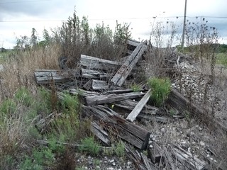
Garbage Dumps of Ainsworth, Part 1

P1000192
(Click on image to enlarge)

This pile of decayed railroad ties, old tires, gravel and other debris sits on the empty strip of land between Ainsworth Road and the Grand Trunk Railroad. Its components have been there for God knows how long, but this piled-up configuration is of relatively recent origin — maybe 10 years, dating back to a time when some extensive work had to be done on the adjacent section of the track, and the railroad brought in a bulldozer and pushed all the scattered debris into a nice, neat pile to get it out of the way of the workers and their equipment.

A neighbor told me that that section of track tends to have problems because at the time Ainsworth Road was re-routed, the railroad did a slapdash job of deconstructing the old Ainsworth Road crossing. The work that resulted in this pile of garbage may have corrected the problems, if that story was correct.

With respect to garbage dumps, my dear friends, this is only a taste of things to come; but you will have to be patient, because Ainsworth's most intriguing garbage dumps are at present covered in dense summer vegetation and not easily photographed. I will cheer your winter hours with photos of the more interesting dumps if it doesn't snow too much.

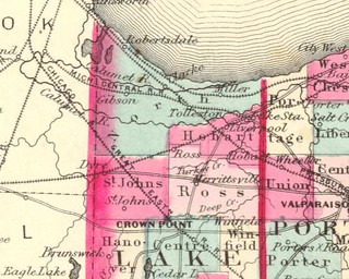
Lake County 1883

1883LakeCounty
(Click on image to enlarge)

From George F. Cram, Indiana (Chicago: George F. Cram, c.1883), via the University of Alabama.

And there it is — Ainsworth! And there is the Grand Trunk Railroad — or, as Mr. Cram has it, the "Chicago & G'd Trunk R.R." There are the next station-stops, Redesdale to the west and Sedley to the east, both now as imperceptible as Ainsworth.

Saturday, August 22, 2009

Lake County 1880

The University of Alabama has a couple of 1876 maps, but as they are at the state level, they are much less detailed than the county- and city-level maps I have already posted, so I omit them.

Let us pass over to 1880:

1880LakeCountynorthern
(Click on image to enlarge)

From Frank A. Gray, Indiana (Philadelphia: O.W. Gray; from The National Atlas, 1880), via the University of Alabama.

Alas, no Ainsworth on this map; no Grand Trunk Railroad, either, although both existed in 1880. The map must have been published early in 1880. Or Mr. Gray had an 1879 map and figured nothing much would change in a year out in a hick state like Indiana, so why go look for himself?

I'm kidding. No offense to Mr. Gray's memory intended.

* * *

Ainsworth is both quiet and surrounded by railroads, so you can hear the trains coming from a long distance on the Grand Trunk Railroad, and the whistles of the trains passing through downtown Hobart are so audible you sometimes mistake them for Grand Trunk trains.

I awoke at five o'clock this morning, looked at the clock, closed my eyes and tried to go back to sleep. The weather is windy and chilly enough to cool the house without my running window fans all night, so instead of their electric hum I heard only crickets and the rise and fall of the breeze — and far, far away, a train's whistle. (We still say "whistle" even though, these days, the noise is less flutish and more brassy, like a car's horn.) Then silence, whistle, whistle; silence, whistle, whistle, as the faraway train passed over crossings in succession, while I, thinking it a Grand Trunk train, sleepily tried to enumerate the crossings — if from the east, Union Street, County Line Road, Randolph Street; if from the west ... well, I'm too sleepy to remember the roads the train must cross. And then by fits and starts came the train's rumble, too low to be heard unless the wind rose and carried it. I lay waiting for the sound to grow louder, from that distant grumble to the ear-drowning roar as it passed through Ainsworth. But whistle, and whistle, and fitful rumble, and now the sound was moving across the world and coming from the other hemisphere, as the train moved through downtown Hobart, heading toward — Valparaiso? Who knows where those trains go?

As for me, I fell asleep again and dreamed my computer was all messed up by a virus. But it was only a dream.

Friday, August 21, 2009

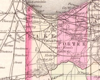
Lake County 1873

1873LakeCounty
(Click to enlarge)

No Ainsworth. The "Calumet" River is here given as "Calumic," a spelling that shows up occasionally on old maps. A variant transcription of the Indian name for that river? White people couldn't make up their minds what to call it? — I don't know.

Boring entry, but I feel like crap today.

Just to make up for this stupid entry, here's a pretty picture of some clouds after the storm the other day (click on image to enlarge):

P1000175

Thursday, August 20, 2009

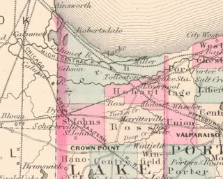
Lake County 1870 (northern half)

1870LakeCountynorth
(Click to enlarge)

Via the U. of Alabama, from Alvin J. Johnson, Johnson's Indiana (New York: A.J. Johnson, c.1870).

Merrillville is still "Merrittsville." No Ainsworth, at least not in Indiana. There is one just over the border in Illinois, along a railroad that may be either the Michigan Southern or the Cincinnati, Peru & Chicago — hard to tell on this map. Those Ainsworths got around, didn't they?

Miller, but no Gary. Robertsdale, but no Whiting.

* * *

Freight trains still stop here in Ainsworth — when their own train-traffic reasons require it — occasionally blocking State Road 51. Sometimes they stop so quietly that if I'm inside the house and not paying attention I don't realize the train has stopped rather than just passed out of hearing. But presently the continual whoosh ... whoosh ... whoosh of cars down Ainsworth Road draws my notice, and a glance out the window confirms: stopped freight train. The cars are looking for a way around the train, and it's either make a U-turn and go back north on State Road 51, or turn east onto Ainsworth Road. Sometimes the train stops for 20 minutes, or more, while some drivers sit there — fuming, or listening to the radio, or shouting into their cellphones, "Hey, I'm going to be late — yeah, there's a damn freight train..." or just thinking about how their lives have turned out — and others drive around in unaccustomed routes or back roads they've known for years, looking for a clear crossing. So at least in that way the Grand Trunk Railroad still has a powerful effect here in the ghost of Ainsworth.

Wednesday, August 19, 2009

Lake County 1864 (northern half)

1864northernLake
(Click to enlarge)

Via U. of Alabama, from Alvin J. Johnson, Johnson's Indiana (New York: A.J. Johnson, c. 1864).

No Ainsworth. Merrillville given as "Merrittsville."

In the course of the American Civil War, Indiana furnished 196,363 soldiers, sailors and marines. Of those, 26,672 died, in battle, in prison, of disease, or from other causes. (Source)

Lake County casualties, from the Rev. T.H. Ball's Lake County, Indiana : from 1834 to 1872 (Chicago: J.W. Goodspeed, 1873), as transcribed at Genealogy Trails.

Tuesday, August 18, 2009

An Ainsworth Sunset

AugustSunset
(Click image to enlarge)

Q.: Why am I in the house an evening like this, when I could have sat out in the yard as the sun set and darkness fell, listening to the cicadas, the crickets and the frogs instead of watching "More to Love"?

A.: Because I'm an idiot.

Lake County 1856(?)

1856LakeCounty
(Click to enlarge)

Via U. of Alabama, from Colton, J.H., Colton's Indiana (New York: J.H. Colton, 1856).

This map shows the Pittsburgh, Fort Wayne & Chicago Railroad running at least through Valparaiso, and yet The History of Porter County, Indiana (Chicago: F.A. Battey & Co., 1882), as excerpted here, states that said railroad "was laid through Porter County in 1858."

The U. of Alabama may be mistaken about the publication date. Here, the publication date is given as 1859. I leave it to someone with a better-than-dial-up connection to try to figure out if those are the same maps. I don't really care, because Ainsworth doesn't show up on this map, and, of course, the Grand Trunk Railroad is about two decades in the future.

Just to add to the confusion, there were two different Coltons (J.H. and G.W.) making maps of Indiana in the 19th century.

Monday, August 17, 2009

Lake County 1837

1837LakeCounty
(Click to enlarge)

This map comes, via the U. of Alabama website, from J.H. Young, The Tourist's Pocket Map of the State of Indiana, Exhibiting its Internal Improvements, Road Distances, etc. (Philadelphia, S. Augustus Mitchell, 1837).

The map shows Lake County as a vast emptiness containing only rivers, but Lake County was formally organized February 15, 1837. There were hundreds of people living in the county, and Crown Point, for example, was settled in 1835. These may have been squatters on government-owned land; perhaps that was Mr. Young's problem, or maybe he just ran short of ink.

On this map Lake County's southern boundary is not, as at present, the Kankakee River.

Over the counties south of Lake appears the legend "Country Ceded by the Pottawatomies."

I have nothing further to say. You're lucky I said this much. This is one of those days where all I want to do is sleep.

Sunday, August 16, 2009

Wildflowers of Ainsworth: Chicory

Chicory
(Click to enlarge)

Yeah, I know chicory grows all over the place, but it grows in Ainsworth, too, and I have a new digital camera, so why not use it?

Chicory blooms every morning and fades every afternoon.

The road leading into a subdivision where I sometimes visit is called Chicory Lane. I find that amusing because you never see any chicory growing there. It's probably against the homeowners' association agreement to allow chicory to grow there.

Chicory is historic, in the same way that dirt is historic.

Chicory is one of the few wildflowers I can identify. I have ordered Newcomb's Wildflower Guide from Amazon.com, so I may be getting less ignorant in these matters, but don't count on it.

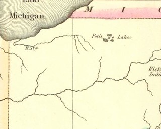
Lake County 1822

The University of Alabama has an interesting collection of historical maps of Indiana.

For purposes of this blog I have extracted Lake County from some of those maps, since we don't care about the rest of Indiana, now, do we?

And so, without further ado, allow me to present Lake County as it appeared in the Geographical, Statistical, and Historical Map of Indiana by Lucas Fielding, Jr., published in 1822:

1822northwestindiana

River Styx? I don't believe that for a minute.

More historical maps to come.

Saturday, August 15, 2009

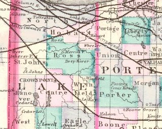
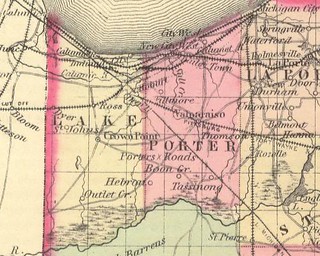
Lake County 1876

I have a single page from an atlas published in 1876. One side shows Lake County, the other side Porter County. I have scanned the Lake County side. It wouldn't all fit on the platen so I had to scan it in pieces.

Here is northern Lake County, including the Ainsworth area, which is not marked except for the little house icon I referred to in an earlier post and which I don't know the meaning of and I'm not going to pay $16.00 plus S&H on Amazon.com to buy a reproduction of this atlas in order to find out. Note the absence of the Grand Trunk Railroad. This part of the map includes a street map of Lowell.

Southern Lake County, not that anybody cares.

Street map of Hobart.

Street map of Crown Point.

Source: Baskin, Forster & Co., Illustrated Historical Atlas of the State of Indiana (Chicago, 1876).

Thursday, August 13, 2009

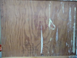
Autographs of Ainsworth, Part 1: Kitchen Drawer

This morning I am cooking and freezing spaghetti squash from my garden. Each squash has to cook for 12 minutes in the microwave, then sit out until it's cool enough to handle comfortably. Then I'll have to scoop out the seeds, scrape the flesh into strands, put the results from each squash into a gallon-size freezer bag and carry the bags downstairs to the freezer. The skins and seeds go out to the compost heap, the contents of which I've never used but I still feel obligated to put fruit and vegetable scraps out there and feel all virtuous when I do.

All in all, pretty time-consuming.

So let us, while we're waiting on the spaghetti squash, move to the topic of my kitchen drawer, and the people who have there memorialized themselves for eternity, or rather for as long as the house stands — or rather, until somebody paints over the kitchen drawer. Or remodels the kitchen and tears out those cabinets, which appear to be hand-made, and I wouldn't trade them for the fanciest line that Home Depot carries, so it certainly won't be me doing the remodeling.

But back to the drawer. Difficult to photograph; in some cases difficult to read, but here are the signers thereto:

Here is a shot of the whole underside of the kitchen drawer:

Drawer
(Click on images to enlarge)

Hard to read, no? Then here are the individual signatories:

Sally Lines
Dec. 19, 42
SAT.
[illegible] Mrs. Fasel
Now

"Norma Lines"
April 26, 1948
Monday

May 5, 1944
Janet Lines

"Sal"
May 19, 45
Tuesday


The inside of the drawer was signed in red crayon by Hubert — presumably Hubert Lines, from whom I bought the house.

And then Norma, that mischievous girl, reached inside the socket into which the drawer fits (sorry, I don't know the correct terminology) and signed again:

Norma Lines
April 26, 1949
HA!
HA!
Tues[?]day


That's it for the kitchen autographs. There was one other that I found in the upper cabinets when I pulled up the old contact paper, but I didn't make a note of it and I'm not pulling up all the new contact paper to find it again.

Back to the spaghetti squash.

Monday, August 10, 2009

Aerial Photos: 1939 (3 of 3)

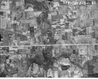
BFJ-01-085
(Click on image to enlarge)

At the center of this photo is the village of Deep River. Unlike Ainsworth, Deep River is not an orphan town; its history is so well documented in the museum at Deep River County Park as to render my commentary superfluous.

The land along the Deep River to the Grand Trunk Railroad is now part of Deep River County Park. North of the railroad I believe it's only the land on the west side of the river that belongs to the park. I seldom walk my dogs in that southernmost part of Deep River County Park because it's too crowded, and too circumscribed.

Sunday, August 9, 2009

Aerial Photos: 1939 (2 of 3)

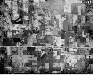
BFJ-04-071 enhanced
(Click on image to enlarge)

This photo was taken at nearly the same east-west position as the one from the previous post, but here we are positioned further to the south. The Ainsworth Triangle is nearly at the top of the photo, while the double horizontal line of Route 30 appears about a third of the way from the bottom.

The exposure is higher, which makes some features stand out more clearly, such as the building I spoke of earlier — the suspected railroad station — that sits right beside the Grand Trunk Railroad on the north side of the Ainsworth Triangle.

There is absolutely nothing at the junction of Grand Boulevard and Route 30.

On the southeast corner of Grand Boulevard and 73rd Street stands a house that has since been knocked down. Here it looks like a significant farming operation. By the time I moved into the area, it was just a house; out back was a shed where a horse stayed, and further out a rusting farm machine. I was fond of the old farmhouse and the weathered wood of the shed, and of course I liked the horse. Then I read in local newspaper a letter from a reader complaining about the existence of that very shed and horse, and the rusting farm machine. I was simply stunned that anyone could find it offensive.

Saturday, August 8, 2009

Off the Wagon

Fell off the wagon, got on eBay and bid on two Hobart High School yearbooks (1926 and 1927). Just found out I won them. Well, that's eighteen bucks I didn't need to spend. I intend to offer them to the Hobart Historical Society.

I suppose I will be talking about Hobart somewhat, since Ainsworth has always been in its shadow and has now been gobbled up entirely by it. I'll be talking of Merrillville, too — incidentally, because Big Maple Lake park is in Merrillville. As if these ephemeral political boundaries had any bearing on the emotions evoked by the roads and fields and houses and ruins and railroad tracks that surround me. You walk east on Ainsworth Road and cross the boundary from Hobart to Merrillville and nothing changes.

Aerial Photos: 1939 (1 of 3)

1939 Aerial Park (BFJ-04-070[2])
(Click on image to enlarge)

This photo is bisected vertically, just to the left of center, by Grand Boulevard, aka State Road 51. Almost at the center of the photo you can see the triangle formed by the intersection of Grand Boulevard, Ainsworth Road and the Grand Trunk Railroad.

Ainsworth Road here appears in its old configuration: it crosses the railroad tracks and connects with Grand Boulevard south of the tracks. These days it veers north to connect with Grand just north of the tracks, never crossing them at all. When I moved out here in 1990, you could still see a line in the pavement of Ainsworth Road that pointed obliquely toward the tracks, marking the road's old path. I don't know exactly when the change was made, but I believe it was post-1973. When they resurfaced Ainsworth Road prior to excavating Big Maple Lake, they covered up the line.

On the north side of the Ainsworth Triangle, you can just make out what appears to be a building right beside the railroad tracks. I suspect that was the railroad station. Two paths have been worn from Grand Boulevard to that building, as if by people coming from the north and from the south.

As you follow Grand Boulevard south, you can clearly see the dark square of the school building, halfway between Ainsworth Road and 73rd Street.

Looking east on Ainsworth Road, you find no trace of Shiloh Ranch or the sheep farm buildings. Once you pass the tiny house and barn at 6720, there is nothing until the collection of buildings that surrounded the house at the western border of what is now Big Maple Lake park. The house still stands today, and as for the outbuildings, you can find their ruins among the trees that have filled up the fields on both sides of the road.

Continuing eastward along Ainsworth Road, you come to a collection of buildings on the north side of the road, just edging the dense vegetation that marks the Deep River.

When I first started taking my dog for walks in the forest around Big Maple Lake, I noticed great blocks of broken concrete piled along the path at the east end of the park. I thought, who would go to all the trouble of driving up this little path to dump their debris in the park? What's wrong with people? and so on. But a little more exploration showed me that the debris hadn't been imported — it was the remains of some mysterious structure that had been built and then demolished on that site. Deep among the trees, among the thickets of poison ivy and the thorns of multiflora rose, I traced the concrete foundation of a long, narrow building. Elsewhere there were remnants of electrical conduit, fencing, gates, truck bumpers, glazed bricks and, further towards the river, what seemed an archeological treasure trove of garbage that people had dumped down the high, sloping bank of the Deep River. Further investigation of the remains and the garbage dump proved it all disappointingly modern, but I was still curious about what the structures had been and who had built them. I haven't found out yet.

Anyway, there they stand, pristine in an open field, in 1939.

Wednesday, August 5, 2009

Sidewalks

The Reverend T.H. Ball may as well have said of Ainsworth that it has a school but no sidewalks. I do not believe there is or ever has been a sidewalk anywhere in Ainsworth.

Monday, August 3, 2009

Ainsworth Station

I believe it was in Bad Land: An American Romance by Jonathan Rabin (a book I highly recommend) that I read of the establishment of towns along new railroads crossing the Great Plains — towns set up entirely by the agents of the railroad, who were instructed to locate a town every so many miles along the railroad, and who assigned each town a name pulled out of their own whimsy. And so a station would be built, and the town would grow up around it, with no more basis than that the railroad happened to pick that spot.

I don't know in what way Ainsworth existed before the Grand Trunk Railroad was built through Lake County in 1880 and established the "Ainsworth" station. I have a map of Lake County published in 1876 on which Ainsworth does not appear, although such distinguished metropolises as Liverpool, Tollestone and Ross appear, as does Hobart, of course.

On this 1876 map I do see a road resembling Ainsworth Road, and there's a little house icon where Ainsworth Road crosses what seems to be the beginnings of Grand Boulevard. I don't have the whole atlas with its key, so I don't know what the house icon represents.

(By the way, I will start publishing images as soon as my new memory card arrives and I install it. Right now my computer is teetering on the brink of the Chasm of Unremembering and can't handle the scanning of images.)

Then comes 1880, and the Grand Trunk Railroad builds a station with a day telegraph office, somewhere close to the junction of the railroad, Grand Boulevard and Ainsworth Road. I have no idea what induced the railroad to put a station there, whether it was a matter of a station every X number of miles, or a promising junction of roads, or some person(s) with influence.

Trains traveling westward toward Chicago, originating in Ft. Gratiot, Michigan, or Valparaiso, Indiana, stopped in Ainsworth daily at 7:03 AM and 5:08 PM. Eastbound trains, from Chicago to Fort Gratiot or Valparaiso, made the Ainsworth stop at 11:07 AM and 7:21 PM daily, with a Sunday train at 3:17 PM. Local farmers shipped milk from the Ainsworth station to Chicago by the morning trains; evening trains returned the empty milk cans.

By 1882 Ainsworth had a post office (closed 1934); by 1900 the Rev. T.H. Ball described Ainsworth as "quite a shipping point for milk" with "some other business interests, with a population now of about fifty, fourteen families. It has a school house but no church." (Whether the school house referred to is the two-story brick one still standing, I'm not sure. Kenneth J. Schoon gives two dates for the building of an Ainsworth school — 1900 and 1912.)

I don't know the precise location of the station, but I have an idea, based on the 1939 aerial image. More on that later.

Somehow I have the idea that the station ceased operation in 1971, but I don't know where I got that figure.

By the time I moved here in 1990, Ainsworth as a town was imperceptible. The town itself was not incorporated, and no signs on the road bade you welcome to Ainsworth. My first month here, a neighbor who stopped by to talk to the guy pumping out my septic tank said something to me about "us folks here in Ainsworth," and that was the first I heard of such a place. As Hobart's fight to annex the Ainsworth area intensified, I would notice, as I drove around, that some yards had signs reading "Freedom for Ainsworth," or similar slogans. Ainsworth didn't get its freedom, as we know; it disappeared into Hobart. Its only revenge was that the Hobart mayor who had presided over the annexation effort, Robert Malizzo, was voted out of office largely by Ainsworth-area voters.

Sources:
  • Ball, the Rev. Timothy Horton, Northwest Indiana from 1800 to 1900 (1900).
  • Ball, the Rev. Timothy Horton, Encyclopedia of Genealogy and Biography of Lake County, Indiana (1904), as transcribed at Genealogy Trails.
  • Chicago and Grand Trunk Railway Gazette, Vol. 1, No. 1 (September 1883).
  • Schoon, Kenneth J., Calumet Beginnings: Ancient Shorelines and Settlements at the South End of Lake Michigan (2003).

Railroad Nomenclature: Apology

Whenever I speak of the railroad that passes through Ainsworth, that is such a prominent feature of life in Ainsworth, I'm going to call it the Grand Trunk Railroad, even though I'm aware that it's actually the Canadian National Railway. It's also been called the Grand Trunk Western, and you will find much information on it by Googling that phrase. I have a newsletter from 1883, which was distributed to passengers at all stations, wherein the railroad refers to itself as the Chicago and Grand Trunk Railway. I've seen maps whereon it's designated as "G.T.R.R."

I'm not a purist. To me "Grand Trunk Railroad" is the most evocative name, and what I'm doing here is all about evocation.

Sunday, August 2, 2009

Ainsworth in Wikipedia

It's hard to believe that someone took the trouble to write a Wikipedia entry about Ainsworth — even a stub — and yet, someone did.

And speaking of insanity (as I was yesterday), I just mailed a check for $108 to the Indiana Commission on Public Records for aerial photos dating from 1958, 1965 and 1973. I already have 1939 aerial photos, but I got those for free.

If you're interested in Indiana aerial photos, your first stopping point is here — the Indiana Historical Aerial Photo Index of the Indiana Geological Survey. Not easy to use, but a wealth of information that you will need to get yourself aerial photos.

I will post those 1939 aerial photos as soon as I have some time to kill. Right now I have to clean the house.

Saturday, August 1, 2009

The Why of This Blog

Albert Einstein defined insanity as "doing the same thing over and over again and expecting different results." By that definition, I'm insane. By constant disappointment and the expenditure of much money, I'm learning to recognize my insanity when it strikes and reason myself out of it, so that I resist the temptation, let's say, to bid on yet another old diary on eBay in the hope that somehow, this time, I'll happen upon just the right way to turn the pages or scratch the ink so that the living, breathing past rises up off the page and becomes the present — but with me present in it, and then —

And then what? I have no idea. I don't know what I want from the past. I love the internet, I love penicillin, I love air conditioning, I love the right to vote. Perhaps it's peace and quiet: how wonderful it would be to step outside my house of an evening and hear the frogs singing instead of the continual, drawn-out whoosh of cars passing my house every three minutes, of more cars driving by on State Road 51, and the distant, ceaseless roar of traffic on Route 30. Perhaps it's the ability to see the stars as I once saw them in the night sky over a farm in Missouri in 1970 — the Milky Way like a dusty path across the heavens.

But if it's peace and quiet and stars I want, a more reasonable way to go about getting those things would be to move to some remote area in Wyoming.

Perhaps it's a vague belief that in another time I would be another person — a reasonable enough wish, in my case — but a more reasonable way to cope with that problem is that wonderful modern invention, Prozac.

So it's been with some undefined but impelling desire that I've gone about doing the same thing over and over — bidding on eBay for some diary or letter or photograph; sending away good money through PayPal; waiting impatiently until that happy day when my purchase comes in the mail and I unwrap it ... and it sits inert and useless in my hand.

I fall off the wagon very rarely these days, with respect to buying things on eBay and expecting anything to come of it.

And yet here I am, doggedly if desultorily (and expensively) researching Ainsworth, Indiana, a town that politically doesn't exist, that physically is hardly noticeable, that probably even in its heyday was not an interesting place to live.

And somehow, deep in my heart of hearts, I really do suspect that when I finally establish that the railroad station was where I think it was ... something will happen. I don't know what, but something.

So, yes, the why of this blog is insanity.