
(Click on image to enlarge if you really want to, but it's a big file and not very interesting)
Photograph courtesy of the Indiana State Archives, Indiana Commission on Public Records.
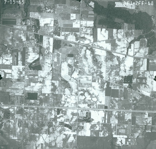
Here we have Ainsworth in 1965. Not a lot has changed since 1958. A few more houses. The most notable addition is on the extreme right, about one-third of the way from the top: a big (race?)track in the area that is now the toy airplane field in Deep River County Park. No idea what, if anything, was raced there. The buildings directly north of it, whose foundations can still be seen among the trees east of Big Maple Lake, are still standing. The Ainsworth depot north of the Ainsworth Triangle seems to be gone; the little toolshed that replaced it may be there but too small to be visible. Ainsworth Road still in its old configuration, crossing the tracks. No Shilo Ranch yet.


2 comments:
I wish that I could make out what's what in this photo since this is from the exact time period when I lived in Ainsworth/Deep River. I'm absolutely certain my house is shown here somewhere; however, I can't make out where County Line Road is, which road is Old Lincoln Highway, or even where the bridge is located.
Unfortunately, this photo is just a little too far west to pick up the village of Deep River. The north-south road furthest to the right in the photo is Randolph Street. The two-land road near the bottom is the NEW Lincoln Highway, so the old Lincoln Highway is the diagonal road that is heading toward the new Lincoln Highway at the right border of the picture. You could look for tile that include Deep River here: https://igws.indiana.edu/IHAPI/Map/
Post a Comment