Wednesday, March 27, 2024
Spicebush
(Click on images to enlarge)
For years, while walking in Deep River County Park in the early spring, I have noticed these shrubs or small trees with tiny yellow blooms. It never once entered my head that they could be Spicebush. I recently posted some pics to the IN Nature group on Facebook and those nice people clued me in.
Spicebush is a larval host of the Spicebush Swallowtail butterfly.
I would describe the bark as pretty smooth, with freckles.
The blossoms, as I said, are tiny, and hard to get in focus, at least for me.
Better pics here.
Thursday, March 21, 2024
Lovers Lane (a/k/a Beer Can Lane)
If you were a young person living in Ainsworth or Hobart in 1963 who wanted to go somewhere to neck and/or drink beer, where would you go? Here's an idea:
(Click on image to enlarge)
Gazette, 25 July 1963.
From the description, Baier Road must have been what is now known as East 61st Avenue:[1] it's the only road that connects County "K" and County Line Road — that is to say, the only such road that isn't Tenth Street, and if it had been Tenth Street, the article would have said so, and would not have said the road was "approximately even with 14th St."
Even now, in spite of the increase in population and traffic around here in recent decades, that stretch of road seems isolated and sparsely traveled.
Here is a 1962 directory listing of the shooter:
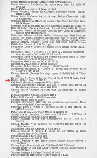
(Click on image to enlarge)
Polk's Hobart City Directory 1962. R.L. Polk & Co.
I would never have known where Baier Road was if not for this newspaper article. But how did it get to be called Baier Road? I have been accustomed to seeing roads named after a substantial farmer on them — e.g., the Chester road (Ainsworth Rd.), the Springman road (Randolph St.) — or a destination they are used to travel to — e.g., the Ainsworth road (Grand Blvd., S.R. 51), the Palmer road (Randolph St. south of the Lincoln Highway). So let's take a look at Baier Road in the 1950 Plat Book:
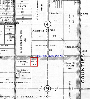
(Click on image to enlarge)
As you can see, the Baiers owned only 4.5 acres according to this plat map, and my earlier and later plat maps don't show them owning any more than that.[2] How did this road avoid being called after the Leszczynskis, or the Malones, or the Zelenkas or Kaars or Blimels?
I suspect the answer might lie in Mr. Baier's job. Peter and Helen Baier first show up in this location on the 1930 Census as a young married couple, with Peter describing himself as a "poultry man," but by the 1940 Census he had become a foreman with the State Highway Department. I wonder if somehow he did some work on that road — although it was not a state road — and thus got it connected with his name? By the 1950 Census Peter was a "General Sup" (supervisor, I'm guessing) in "Home Construction." The three houses now standing on or near the Baier property all date to the 1950s; is it possible that Peter was involved in building them?
One way or another, it seems he was a fairly prominent person in that area, despite his 4.5 acres.
The 1962 Polk's directory lists him on "RD 2" but doesn't add "Baier rd." as in the Ewing listing above.
Speaking of Mr. Ewing, here's an article from the Hammond Times of July 23, 1963, that gives a little more information about him:
(Click on image to enlarge)
I haven't found any follow-up articles about what, if any, penalty was imposed on him.
In the 1962 directory page posted above, the listing directly above Robert's shows his parents, Lee and Anna. Robert had gotten married in 1955 (Indiana Marriage Collection); the marriage produced several children. Robert and his wife, Beverly, appear in my 1991 directory living on 8th Street in Hobart. Robert died in 2007.
The young man who was shot, Jeffrey Johnson, must have recovered, as he went on to lead a full life, and died of natural causes in 2018.
Peter Baier had died in 1987. I wonder when his road lost his name?
_______________
[1] The county assessor's records still use "Baier Rd." in the site addresses for properties on that road, although their mailing addresses use "E. 61st Ave."
[2] One interesting thing I've noticed on many of my plat maps, from 1874 to 1972, is that they seem to show South Union Street running through from Tenth Street all the way to Baier Road. Today there is no trace of any connection: Union St. comes to a dead end well north of E. 61st. But in the 1939 aerial photos, S. Union, while narrow in comparison to the other roads around it, does appear to run all the way south to E. 61st. In the 1973 aerial photos, I can't see a connection between S. Union and E. 61st.
(Click on image to enlarge)
Gazette, 25 July 1963.
From the description, Baier Road must have been what is now known as East 61st Avenue:[1] it's the only road that connects County "K" and County Line Road — that is to say, the only such road that isn't Tenth Street, and if it had been Tenth Street, the article would have said so, and would not have said the road was "approximately even with 14th St."
Even now, in spite of the increase in population and traffic around here in recent decades, that stretch of road seems isolated and sparsely traveled.
Here is a 1962 directory listing of the shooter:
(Click on image to enlarge)
Polk's Hobart City Directory 1962. R.L. Polk & Co.
I would never have known where Baier Road was if not for this newspaper article. But how did it get to be called Baier Road? I have been accustomed to seeing roads named after a substantial farmer on them — e.g., the Chester road (Ainsworth Rd.), the Springman road (Randolph St.) — or a destination they are used to travel to — e.g., the Ainsworth road (Grand Blvd., S.R. 51), the Palmer road (Randolph St. south of the Lincoln Highway). So let's take a look at Baier Road in the 1950 Plat Book:
(Click on image to enlarge)
As you can see, the Baiers owned only 4.5 acres according to this plat map, and my earlier and later plat maps don't show them owning any more than that.[2] How did this road avoid being called after the Leszczynskis, or the Malones, or the Zelenkas or Kaars or Blimels?
I suspect the answer might lie in Mr. Baier's job. Peter and Helen Baier first show up in this location on the 1930 Census as a young married couple, with Peter describing himself as a "poultry man," but by the 1940 Census he had become a foreman with the State Highway Department. I wonder if somehow he did some work on that road — although it was not a state road — and thus got it connected with his name? By the 1950 Census Peter was a "General Sup" (supervisor, I'm guessing) in "Home Construction." The three houses now standing on or near the Baier property all date to the 1950s; is it possible that Peter was involved in building them?
One way or another, it seems he was a fairly prominent person in that area, despite his 4.5 acres.
The 1962 Polk's directory lists him on "RD 2" but doesn't add "Baier rd." as in the Ewing listing above.
Speaking of Mr. Ewing, here's an article from the Hammond Times of July 23, 1963, that gives a little more information about him:
(Click on image to enlarge)
I haven't found any follow-up articles about what, if any, penalty was imposed on him.
In the 1962 directory page posted above, the listing directly above Robert's shows his parents, Lee and Anna. Robert had gotten married in 1955 (Indiana Marriage Collection); the marriage produced several children. Robert and his wife, Beverly, appear in my 1991 directory living on 8th Street in Hobart. Robert died in 2007.
The young man who was shot, Jeffrey Johnson, must have recovered, as he went on to lead a full life, and died of natural causes in 2018.
Peter Baier had died in 1987. I wonder when his road lost his name?
_______________
[1] The county assessor's records still use "Baier Rd." in the site addresses for properties on that road, although their mailing addresses use "E. 61st Ave."
[2] One interesting thing I've noticed on many of my plat maps, from 1874 to 1972, is that they seem to show South Union Street running through from Tenth Street all the way to Baier Road. Today there is no trace of any connection: Union St. comes to a dead end well north of E. 61st. But in the 1939 aerial photos, S. Union, while narrow in comparison to the other roads around it, does appear to run all the way south to E. 61st. In the 1973 aerial photos, I can't see a connection between S. Union and E. 61st.
Sunday, March 17, 2024
Wasp, Where Is Thy Sting?
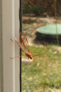
This is some kind of ichneumon wasp …
(Click on images to enlarge)
… exact kind unknown, because apparently there are many, many kinds, and the topic is much too complicated for me.
I didn't even know this creature was a wasp when I found it on the inside of my storm door. (Finding that out took some Googling.) After taking pictures, I gently shooed it out into the open air. It didn't sting me. As it turns out, these wasps, or some of them, or maybe all of the males (this might be a male) — as I said, it's complicated — they don't sting. And I, who thoughtlessly thought of stinging as part of the essence of wasp-hood, must now stretch my mind to a new idea.
The pups have left the building (one has already been adopted), and now I need a vacation after my puppy vacation. Even good boys use up all my bandwidth.
Subscribe to:
Posts (Atom)