
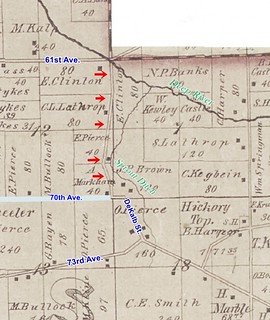
Here is that road on the 1874 Plat Map. It runs north and south along the section line between Sections 12 and 7, except where it bows out westward to avoid Sprout Ditch, and it connects present-day 61st and 70th Avenues.
(Click on image to enlarge)
I had to draw in 70th Avenue myself, since it doesn't show up on this map, except for that brief east-west line connecting DeKalb and the phantom road.
Naturally I wondered whether the 1874 cartographer made a mistake. That would not be the only possible error I've encountered on a plat map. Perhaps subsequent mapmakers didn't bother to verify and just copied the original error.
However, I recently came across an announcement in the microfilm newspapers that throws a wrench into the works of the "mistake" theory.

(Click on image to enlarge)
Hobart Gazette, March 16, 1933.
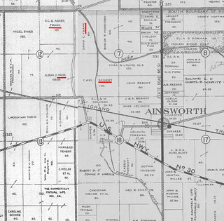
The announcement mentions the surnames of three property owners whose land is adjacent to the road: Frank, Paine, and Sievert. Those match up with the property owners shown in the 1939 Plat Book.
(Click on image to enlarge)
I had to patch two pages together.
The announcement names Henry Sievert, while the plat map shows Carl Sievert owning the land, but I think the plat map just hadn't caught up with the reality that Carl had died in 1929 and his son, Henry, now owned the land.
The announcement seems a little garbled — its heading and opening line specify "vacation" of a highway — that is, abandonment — but it goes on to speak of a "proposed highway" that "will pass through" the described land, as if the road were to be built, not abandoned. And then it says the highway is, or will be, 66 feet in width! That's quite an impressive highway. I'm inclined to think that there was a little carelessness in the drafting or the typesetting of the announcement, rather than that a 66-foot-wide local road was proposed to be built during the Great Depression.
I have searched in vain in the Hobart papers for any information about the outcome of the April 4 hearing mentioned in the announcement. Was the highway officially vacated?
As we see above, the 1939 Plat Book still seems to take notice of a public road there. On the 1939 aerial view, we can still trace the line of the road …

(Click on image to enlarge)
Image via Indiana University's Indiana Historical Aerial Photo Index.
… though it doesn't appear to connect directly with 70th Ave. (and it certainly is not 66 feet in width).
The road is drawn on the 1950 plat map , but not on the 1972 plat map.
Today, if you really zoom in on the Google satellite view, you can see that a wagon-wheel sort of path, probably used by farm machinery, still follows the line of the abandoned road.
That road would come in handy when both the DeKalb Street and the 70th Avenue crossings of the Canadian National Railroad are blocked by freight trains. As this area gets ever more developed, perhaps someday the road will be un-vacated.


No comments:
Post a Comment