Standing at the intersection of U.S. 30 and Colorado street today and looking west, you see a vast expanse of asphalt surrounding big-box stores such as Sam's Club, Wal-Mart, and Home Depot, as well as restaurants and gas stations. Thousands of vehicles pass through the intersection, day and night. The parking lots are never empty. The lights never go out.
You can hardly imagine those hundred-plus acres as quiet farmland. You can hardly imagine U.S. 30 ending there, either; and yet all the maps we have show the road that is now U.S. 30 going no further east than Colorado, until the new Lincoln Highway came through in the mid-1930s.
I have been researching that area because the Merrillville-Ross Township Historical Society received an inquiry about the farm that once lay there — specifically, the farm of Frank and Catherine Willy, which comprised approximately 115 acres on the west side of Colorado Street, cut in half by the road that is now U.S. 30.
Here is my attempt to outline the Willy farm on the modern-day Google satellite view:
 (Click on image to enlarge)
Image from Google.com.
This farm, under various owners, had retained nearly the same dimensions for over a century. The earliest record I can find of it comes from the NWIGS'
Early Land Sales, Lake County: on October 18, 1852,
Harmon Underwood bought a total of 160 acres.
[1] On January 11, 1854, those 160 acres became the property of John Underwood, who I believe was Harmon's
son.
[2]
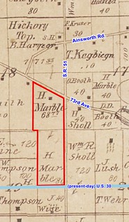
Sometime between 1854 and circa 1874, the farm lost 40 acres on the west, as we can see on the
1874 Plat Map:
 (Click on image to enlarge)
The new owner of those 40 acres, P.A. Banks, was probably
Parley A. Banks. You can also see that H[armon?] Underwood owned another 200 acres east of the original farm.
And lastly, you can see that the mapmaker has clearly drawn a road from the west up to what is now Colorado Street, but eastward of that point, there is no trace of a road.
The
1891 Plat book does not include Section 23, so next we have to jump forward to 1908. Now we find the farm owned by Mary Burge.
 (Click on image to enlarge)
We also find the parcel reduced in size by almost five acres, taken, I believe, by the Chicago, Cincinnati & Louisville (later Chesapeake & Ohio) Railroad, which began buying up right-of-way through Ross Township circa 1903.
My best guess as to the identity of Mary Burge is that she was a daughter of Julius and Nancy Demmon and married Winfield Scott Burge in 1878. The
1900 Census shows Winfield and Mary, with numerous children, living on their own farm in Ross Township in the general area of Colorado and U.S. 30 (to judge by their neighbors). Mary died in
1922. By the mid-1920s the farm had been sold: we find a new owner in the
1926 Plat Book.
 (Click on image to enlarge)
I cannot identify Caroline Schwer.
In 1932 the farm changed hands again. I will let the new owner tell the story of how that came about, as he told it to his descendants:
Three Ears of Corn
by Frank Anthony Willy
After Frank and Catherine were married, they moved onto a farm in Dyer, Indiana, which Frank rented from his father August. Besides charging rent, August required his son to hire his brothers to work the farm. This was a difficult situation at best for Frank and Catherine. During the Depression they had little money to spend and Frank's brothers were teenagers, with poor work ethics. Eventually Frank and Catherine realized that they could no longer afford to rent the farm in Dyer. They knew they would have to go out on their own and start a new life away from Frank's family.
Frank set out to visit three farms that were for sale nearby. The first was in Wisconsin. The ears of corn in the fields were large and well-formed and the house was well built with a natural spring underneath that could be used to keep food cold. This farm, he thought, would be an excellent choice.
The second farm he visited was in Illinois. Once again, the corn in the field was large, showing that the soil had been well taken care of. The outbuildings and home were also in excellent shape. He believed this would be a good farm to own.
Lastly, Frank visited a farm for sale in Indiana. This corn was just "nubbin."[3] The soil seemed to be spent, with most of the nutrients used long ago. The farm and its buildings were neglected and in very poor shape. As he took pictures of this farm he thought, "This is a very poor farm. It would be difficult to make a go of it here." As Frank returned to Catherine to tell her of his trip, his heart was heavy. He laid an ear of corn from each farm in front of her and then began to cry, for he knew the only farm they could afford was the neglected one in Indiana. And so it came to pass, that in 1932, Frank and Catherine Willy moved their family of eight and all they owned to the neglected Indiana farm with "nubbin" corn. Little did either of them realize what an excellent choice it would turn out to be.
(Story courtesy of Nick Hopman.)
Frank was then about 35 years old, Catherine (née Alber) about 32. They had been married in 1920.
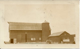
Frank mentions taking photos of the farm when he first visited it. That may be the source of these two photos of the farmhouse and barn.
 (Click on images to enlarge)
This and the following image courtesy of Nick Hopman.
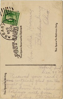
Again, thanks to Nick Hopman, we have Frank Willy's own story about the early days on the farm, and what the construction of the new Lincoln Highway did for the family:
You kids first went to St. Peter and Paul's School. I had to drive you. But when I had no money to buy gas, I sent you to the Ainsworth school as the bus passed our house. The first day you came home you said you needed about $14.60 for books. Had to sell corn for $.12 a bushel. Had about $.60 over on that truckload. That shows you what the Great Depression was like. I did not sell any more, as Henry Bloom[4] said, "Don’t sell. I will go along with you if it takes ten years. I won't foreclose on the mortgage!" The mortgage was for $7,000. The next year we had the cinch bugs. Twenty acres of corn barely filled my little silo. The next year we had the great dust storm. Steady wind from the southwest. In Kansas the dust covered fences and buildings. People left their farms. We bit our lips and held on.
Had 12 acres of fine wheat. Wanted to cut it on Monday. Henry Bloom was out on Saturday. "You ought to cut it. Sometimes it don't pay to wait 'til it has fully ripe." Sunday night it hailed. Shocked everything flat. Holes in the tarpaper roofs. Cut off branches of trees. It was a quarter-inch thick on the ground. I raked the wheat field and got Hank Homeier[5] to come and thrash it. Blew the straw into the barn and got 60 bushels of wheat. I needed that straw. Also paid Koehler[6] $10 so I could cut some slough grass, and Old Nick (our hired hand) herded the cattle there. In 1934 the new highway (US 30-the Lincoln Highway) came through. Then I had it made. When US 30 road work was being done I rented a small area to the state for material storage. When the work was done, instead of having the state clean up the storage area by removing the remaining sand, gravel, and steel, I negotiated to do it myself, for a price of course. But instead of cleaning up the mess, I just sold the materials until they were gone.
For some reason, the
1939 Plat Book fails to show the new highway east of Colorado:
 (Click on image to enlarge)
But the 1939 aerial view shows it clearly:
 (Click on image to enlarge)
Image from https://igws.indiana.edu/IHAPI/Map/.
This raises the question whether the 1874 cartographer just made a mistake about the road extending east of Colorado, and that mistake was perpetuated by subsequent map-makers who didn't bother to investigate for themselves. But I am going to ignore that possibility because it's just no fun at all.
Anyway, the
1950 Plat Book shows the new U.S. 30:
 (Click on image to enlarge)
As you can see from the 1939 aerial view above, the Willys' house and farm buildings stood on the west side of Colorado Street, north of U.S. 30. This photograph shows more clearly how the buildings were arranged in relation to Colorado Street, which runs diagonally across the bottom of the photo:
 Image courtesy of Nick Hopman.
Frank and Catherine Willy farmed that land for 30 years, through the Great Depression, through World War II, and beyond. Their children grew up, moved out, started families of their own. Frank and Catherine bought a modern ranch house in the Green Acres neighborhood. In 1962, they sold their farm.
Here is the former Willy farm as it appears in the
1972 Plat Book:
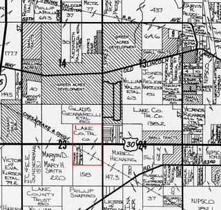 (Click on image to enlarge)
The new owner probably rented most of the land to locals who were still in the farming business.
This 1978 aerial view from the
Lake County GIS website shows that the farmhouse and outbuildings have been removed, and some kind of business is operating in the northwest corner of the U.S. 30/Colorado intersection:
 (Click on image to enlarge)
The 1990s brought the era of the big-box store, and the landscape of the old farm was utterly transformed.
_______________
[1] He bought the south half of the northeast quarter, and the north half of the southeast quarter.
[2] Cf. Lake County Encyclopedia, p. 80. I'm a bit confused.
[3] "Nubbin" — a small or imperfect ear of corn [per the author].
[4] We don't know for certain who Henry Bloom was. My best guess is Henry Blume (1867-1958), who shows up in the 1910 Census farming his own land in Center Township, but in all subsequent censuses he gives no occupation. He and his wife, Mary, had only one child, who died in 1920.
[5] I think this was Henry Homeier, who farmed northeast of Merrillville.
[6] I give up.