
Then I received an inquiry about the farm's history and decided to look into it a little more. I didn't actually learn a lot, but I'll be darned if I spend that much time researching and not get a blog post out of it.
The earliest record I can find of that land is in Early Land Sales, Lake County. Unfortunately, the book shows those 80 acres being purchased in September 1850 by both Hiram Bonesteel and Caleb Pierce.
Hiram Bonesteel was born in 1809 in New York. His wife, Phoebe, was from Vermont. The 1850 Census shows the Bonesteels in Illinois, but they were in Ross Township for the 1860 Census:

(Click on image to enlarge)
Image from Ancestry.com.
(You will notice that there was a Hiram Bonesteel, Jr., further up the page, who would have been too young to buy land in 1850).
Here are Hiram Sr. and Phoebe in the 1870 Census:
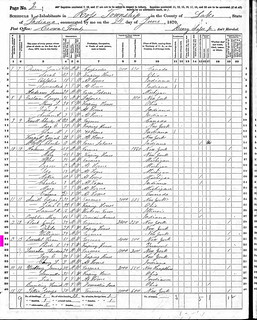
(Click on image to enlarge)
Image from Ancestry.com.
Phoebe died in 1872, Hiram in 1874, and both are buried in Crown Point.
As for Caleb Pierce, he and his wife, Almira, both came from New York, where he was born in 1808. They show up in Ross Township in the 1850 Census and 1860 Census, then disappear. (Merrillville historian Alice Flora Smedstad tells me that her Great-Great-Great-Uncle Caleb moved to Wisconsin and died there.)
Since census records don't give exact information about where people lived, I can't be sure of which of these people actually lived on those 80 acres. It would have been nice to know, since the farmhouse on that land was built in 1860, according to the county records, and I could have made an informed guess as to who built it.
Next, we turn to the plat maps. The earliest one I have, circa 1874, shows the entire 80 acres owned by someone named C.C. Ely:

(Click on image to enlarge)
From the 1874 Plat Map.
I believe he shows up as Coles C. Ely in the Ross Township census of 1880:

(Click on image to enlarge)
Image from Ancestry.com.
Coles' wife, Clarissa, was a Bonesteel by birth; surely she was related somehow to Hiram Sr. and Phoebe — possibly a daughter? Coles and Clarissa came from New York State and seem to have moved around a bit between Indiana and Illinois, to judge by where their children were born. Coles died in 1901, Clarissa in 1913, and both are buried in Graceland Cemetery, Valparaiso.
The 1874 map shows a farm west of the Elys' owned by H. Bonesteel. That might be Hiram Sr. himself, as his H-initialed sons, Hiram Jr. and Henry, seem to have left the area after 1860 (ending up in Washington County, Kansas).
The 1891 plat book compiled by the Northwest Indiana Genealogical Society doesn't include Section 25 of Ross Township, so I don't know who owned it then.
The 1908 plat map shows the 80 acres being owned by Albert C. "Sanger," but I am pretty sure that is a misspelling of Saager (which also shows up in various places spelled "Saeger" and "Sayger").

In that neighborhood also, August Saager owned the land on Colorado Street that would eventually be the Prochno farm, where Lester Harms' wife, Matilda "Sue," grew up. Matilda's mother was Louise Saager, August's daughter, who married William Prochno. I believe Albert was August's son and Louise's brother.[1] Here is Albert in the 1910 Census with his wife, Ida (née Luebcke), and their two sons:

(Click on image to enlarge)
Image from Ancestry.com.
The 1900 Census also showed Albert and Ida in that general vicinity, to judge by the names recorded on the same page, but they were renting their farm.
Albert Saager continued to own those 80 acres in the 1926 plat map and the 1939 plat map, and the family was recorded there in every census from 1910 to 1940 (although Ida died in 1924).
Finally, in the 1950 Plat Book, Lester Harms shows up owning the 80 acres. Lester, born in 1904, was recorded living on his parents' Cleveland Avenue farm in the 1920 Census through the 1940 Census. So he likely bought the Harms Road land sometime between 1940 and 1950.
Per the 1972 Plat Book, Lester and Matilda apparently sold off about 10 acres of their land north of Harms Road.
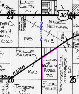
That is the most recent plat map I have.
Lester and Matilda lived on the farm to the end of their lives. Matilda died of cancer in 1980. Lester married Margaret Holt in 1981. On April 5, 1982 Lester shot himself in a shed on his farm (that shed is no longer standing). He is buried in Graceland Cemetery, Valparaiso.
The family that owns the property now bought it at auction in 1985 from Lester's widow.
_______________
[1] It's a bit confusing because there were two Albert Saagers in Lake County, both born in the 1870s, both with a wife named Ida, and both of whom died in the 1940s.


No comments:
Post a Comment