
(Click on image to enlarge)
Image courtesy of the Hobart Historical Society.
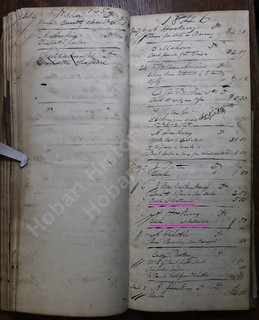
The first marked transaction involves, I believe, Jacob Vanvolkenburg.[1] According to Early Land Sales, Lake County, in 1839 he bought 40 acres in St. John Township, right on its border with Ross Township. He shows up in Lake County in the 1840 Census, and while that census does not specify townships, I see among his neighbors other names that appear in our ledgers. By the 1850 Census he was living in Ross Township, describing himself as a millwright. The 1860 Census shows him still in Ross Township, now farming. His land lay in Section 19, according to the 1874 Plat Map,[2] — but by 1874 poor Jacob himself lay in Merrillville Cemetery, having died (according to the coroner's inquest) a cold and lonely death in October 1862.
(Click on image to enlarge)
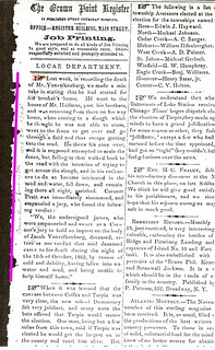
Crown Point Register, Oct. 30, 1862.
As for the second marked transaction, I am not entirely sure who A. Hoskins was: the Hobart area contained both an Alexander and an Ariel old enough to transact business in 1846.
Alexander bought land in Section 5, south of the town of Hobart, as early as 1843 (Early Land Sales, Lake County). He thus lived near Old Settlers Cemetery; and since his wife had been Emma L. Colburn (Indiana Marriage Collection), it would appear that the infant Allen Hoskins whom NWIGS recorded in that cemetery was theirs — "son of A. & E.L."
Ariel, on the other hand, lived slightly northeast of Hobart. Early Land Sales, Lake County records him buying land in Section 28 in 1848. I believe he shows up in my index once as "Rial Hoskins," so perhaps we're better off betting on Alexander as the "A. Hoskins" of the ledger.
Beyond that I know very little about either of them.
_______________
[1] The name shows up in various spellings. I am using the spelling that appears in NWIGS' Ross Township Cemeteries listing.
[2] If I'm reading the plat map correctly, Jacob's land was on the northeast corner of the intersection of U.S. 30 and Whitcomb Street … but I'm not sure I'm reading it correctly.


No comments:
Post a Comment