
(Click on image to enlarge)
I do not know when E.L. Arment purchased these 20 acres. The 1891 Plat Book has Annie Ford written in as the owner, over a crossed-out "A.R. Castle." If we go back to the 1874 Plat Map, we find another Castle owning the land.
Anyway, now — at September 1921 — comes the announcement that E.L. Arment intends to construct a six-room bungalow on his 20 acres, and has given Frank MacPherson the contract to build it.
I am having some trouble positively identifying Mr. Arment. I suspect he may have been Elmer Livingstone Arment, who in November 1900 had married Maud Rifenburg of Hobart. Elmer had worked as a guard at the Indiana State Prison at Michigan City from 1900 (or earlier) on through the first World War, but by 1920 he had gone to work at a steel mill in Gary. It appears he managed to get himself counted twice in the census — once at home in Michigan City, where Maud naturally enough gave his name to the census enumerator as the head of the household; and on the same day in Gary, where he was listed as a lodger in a steelworker's home.
The six-room bungalow may have been intended as a new home for his family, but I have yet to confirm that they ever lived in it. Or even that it was ever actually built, much less still standing.
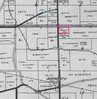
One report on the Arment land described it as "opposite the Richard Carlson fruit farm." As you can see from the image above, opposite the Arment place is the 80-acre farm that once belonged to Swan Peter and Hedvig Carlson. We know that 20 acres of that parcel were sold in 1919 by a daughter of the Carlsons, at which time I wasn't sure what had become of the other 60 acres. Per the 1910 census, among the Carlson children was a son named Richard, who would have been about 35 years old in 1921; perhaps he owned another parcel carved out from the original 80 acres, and used that land to raise fruit (although no census describes him as a farmer). If that's the case, it suggests the old homestead was divided up among the survivors after S.P.'s death. (The 1926 Plat Book shows that land in several small parcels — too small to show the owners' names — while one of the small parcels was owned by a Carlson per the 1939 Plat Book.)
Sources:
♦ 1900 Census.
♦ 1910 Census.
♦ 1920 Census.
♦ 1930 Census.
♦ Indiana Marriage Collection.
♦ "Local and Personal." Hobart News 8 Sept. 1921.
♦ "Local Drifts." Hobart Gazette 29 Mar. 1918; 9 Sept. 1921; 16 Sept. 1921.
♦ WWI Draft Cards.


No comments:
Post a Comment