Tuesday, January 28, 2025

Mills of Mystery: Walton

[continued from here]


Regarding Walton's Mill, Solon Robinson gives us only the surname and the general location, "on Turkey Creek." Turning to Early Land Sales, Lake County, we find a Charles Walton, in 1840, purchasing the east half of the southwest quarter of Section 2, Township 35 N., Range 8 W.:

2025-01-28. Sec. 2, Twp. 35N, R. 8 W - Walton
(Click on image to enlarge)
Screenshot from Google Maps.


As you can see, this parcel of land lies over Turkey Creek, and on its eastern side, Liverpool Road — a main-travelled road in those days — provided a way for customers to reach a commercial venture like a mill.[1]

I believe we have already met this Charles Walton before in this blog: in 1838, when he appraised part of Jeremiah Wiggins' estate, and in 1839, when he came to a Hobart-area store to buy opium and then a coffin for his brother. So he was already in this area before 1840. In fact, Porter and Lake Counties (Goodspeed/Blanchard) tells us that Charles Walton arrived in Ross Township in 1837 [p. 544], and continues: "In 1837 or 1838, a good saw-mill was built three miles northeast of Merrillville by Charles Walton" [p. 551]. That description of the mill's location fits the Liverpool Road/Turkey Creek area.

Goodspeed/Blanchard goes on to say that Charles Walton "sold to Louverman,[2] who ran [the mill] until 1848" [p. 551]. Returning to Solon Robinson's history up to 1847, we find this comment:
There are five saw mills in operation in the county, to-wit: Earle's, Dustin's and Wood's on Deep River; McCarty's on Cedar Creek and Foley's on a branch of Cedar Creek. (There are three dilapidated ones, to-wit: Miller's and Dustin's old mills on Deep River, and Walton's on Turkey Creek, the last about being repaired.)[3]
If the mill was dilapidated and undergoing repairs in 1847, and the mysterious Louverman stopped operating it in 1848, it must have had a short working life in the 1840s.

♦    ♦    ♦

I have found a few more related references in the early daybooks at the Hobart Historical Society museum that I have indexed thus far. Most of them appear below.

The earliest, from November 1836, may not refer to our Charles, but I find it interesting:

2025-01-28. 1836-11 Walton (Miller) - AccB1835 040, 041
(Click on image to enlarge)
Image courtesy of the Hobart Historical Society.


The way the storekeeper wrote that entry seems to say: "I didn't catch his first name, but I know he's a miller." (He could not have been from the town of Miller because it didn't exist in 1836.)


The first clear reference to Charles doesn't come until the summer of 1839. He is all over these two pages, selling cut lumber to the store, and receiving $6.00 in cash:

2025-01-28. 1839-07-17 Walton, Charles - lumber - DayB1836 014, 015
(Click on image to enlarge)
Image courtesy of the Hobart Historical Society.


This water-damaged page of the same daybook shows Charles, in the winter of 1840, selling lumber to the store, and buying a saw:

2025-01-28. 1840-01-10 Walton, Charles - lumber hauled - DayB1836 022, 023
(Click on image to enlarge)
Image courtesy of the Hobart Historical Society.


The first entry under his name reads: "55 ft of lumber hauled by Watkins and left on causeway of ferry." I suppose that was the ferry over the Deep River at Liverpool, about 3.5 miles from Charles' mill up the Liverpool Road.


Here's a non-lumber transaction from May of 1840: Charles purchases some household items (including a "rummer" — a drinking glass) and pays part of their price with 10 and a half pounds of butter and a raccoon skin.

2025-01-28. 1840-05-29 - Walton, Charles - household goods and trade DayB1840 006, 007
(Click on image to enlarge)
Image courtesy of the Hobart Historical Society.


In July of 1840, Charles comes in and buys half a gallon of whiskey.

2025-01-28. 1840-07-29 Walton, C. - last indexed purchase - DayB1840 052, 053
(Click on image to enlarge)
Image courtesy of the Hobart Historical Society.


That same summer (exact date unclear but seems to be in August), Charles furnished lumber for the building of a boat:

2025-01-28. 1840-08-00 - Walton, C. - supplied lumber - DayB1836 034, 035
(Click on image to enlarge)
Image courtesy of the Hobart Historical Society.


Beyond the summer of 1840, I have not found any transactions involving him. The three account books from which I have taken these images go up to 1837, 1846, and 1849, respectively. That boat-lumber may have been Charles' swan song on Turkey Creek, or at least one of its verses. Even if the Waltons remained on the land for some time yet, the mill probably was abandoned soon after 1840: I would expect that several years' neglect were needed for it to become "dilapidated," as Solon Robinson described it, by 1847.

♦    ♦    ♦

As I mentioned in one of those earlier posts about Charles, I have not been able to find any census or other official information about him outside of the 1840 Census, where he and his household appear:[4]

2025-01-28. 1840 Census - Charles Walton
(Click on image to enlarge)
Image from Ancestry.com.


Between 40 and 49 years of age, one male and one female — Charles and his wife, I suppose. That would put their birthdates at about 1795, give or take five years. All the other household members are children under 15 years of age, two boys and three girls. Without names for the wife and children, it's pretty much impossible to determine if any one of the Charles Waltons who turn up when you search on that name and that approximate birth year is our Charles.

As for his brother, whose name is unknown except that it started with S — it's possible that when he died in 1839, he was simply buried on the family's land. To this day, perhaps, his body is still resting somewhere near the spot where Liverpool Road crosses Turkey Creek.


[To be continued …]

_______________
[1] Early Land Sales, Lake County includes a few other purchases by people with the surname Walton (different first names), but none of them bought land on Turkey Creek.
[2] I have failed to turn up any records at all of this Louverman.
[3] "History of Lake County, 1833 – 1847," Lake County 1929, p. 59.
[4] Notice the neighbors listed near him: a who's-who of early Hobart and Merrillville settlers.

Friday, January 24, 2025

Mills of Mystery

Here are some random excerpts from Solon Robinson's "Lake County, 1833 – 1847"[1] that amused me:
In the summer of 1834, most of the land in the county was surveyed by the United States Surveyors, and settlers began to "make claims," and four or five families settled that fall.

One of these I found in October, 1834, in a little shed roof cabin on Sec. 6, T. 35, R. 7, at a place afterward known as "Miller's Mill." His name is already among those that once were, but now are forgotten.

I am inclined to think that an old man by the name of Ross, also settled on the same section that fall. This man was killed by the falling of a tree near Deep river in 1836. (I believe King Alcohol was there to see, and it happened on a Sunday.)[2]

.    .    .

The next family [after Robert Wilkinson's] was that of Lyman Wells; (afterwards well known as "Lying Wells.") With him came "Irish Johnny", now known as John Driscoll.

They came in January, 1835, and settled on Sec. 25, T. 33, R. 9, near where Driscoll now lives. Driscoll was then single, but has since obeyed the scriptural command to multiply and replenish the earth.

Wells had a wife and 4 or 5 children. He lived a few years here and moved further west, and his wife died, and some say the world would not have suffered much loss if he had died too.[3]

.    .    .

Walton's saw mill on Turkey Creek, Wood's and also Dustin's on Deep River and Taylor's on Cedar Creek, were all building during this year [1837]. But with the exception of Wood's they might as well never have been built for the good they have done. The same may be said of the one called "Miller's Saw Mill" on Deep river. Dustin's, Miller's and Walton's have been in utter ruins for years, on account of the difficulty of making a dam of dirt stand, and Taylor's is about half the time without water, and the other half without a dam.[4]

.    .    .

The accommodation of the people of the county was greatly increased this year [1847], in getting grain made into bread stuff, by the mill of Wilson & Saunders on Deep River below Wood's (and as he thinks not quite far enough below).[5]
A little snark livens up history, doesn't it? But I was also intrigued by the references to several local mills I had never heard of before. I wanted to see what information I could find about them (excepting "Taylor's on Cedar Creek," which is outside my bailiwick).

First, let's deal with "Miller's Mill."

Upon learning that this mill was built in Section 6, Township 35 N., Range 7 W., I consulted the 1874 Plat Map and was puzzled because it does not show the Deep River crossing that section:

2025-01-24. Section 6, T. 35 N, R. 7 W -- 1874 plat map
(Click on image to enlarge)

But here is that section as it appears on the Lake County GIS parcel viewer:

2025-01-24. screen shot of Section 6
(Click on image to enlarge)
Screenshot from the Lake County Indiana GIS Hub Parcel Viewer Page.


You can see that 61st Avenue, a/k/a Bracken Road, crosses the river in the southwest part of the section. Also, Solon's Robinson's 1838 map shows the river crossing Section 6. I think we can conclude that the mapmaker of 1874 made a mistake.

The Lake County Encyclopedia, in a chapter containing "Memorial Sketches of Early Settlers," includes this information:
Miller. — There was beyond any room for doubt an early mill seat found and a mill built on Deep River. The Claim Register, which is authority, says: "William Crooks and Samuel Miller in Co. Timber and Mill Seat." Claim made in June, 1835, but settled in November, 1834. Locality, Section 6, Township 35, Range 7. W. Crooks from Montgomery county. This William B. Crooks was elected, in 1837, Associate Judge, and a "Permit" was granted, July 31, "to Samuel Miller to retail foreign merchandise at his store on Deep River." That he had a mill and a store is certain; but of himself very little is known. It is said, and this is tradition and not history, and for its accuracy no good authority can be named, that his wife was part Indian, that he had sold property at Michigan City for eighty thousand dollars in gold and silver, and that much whiskey, as well as other articles of "foreign merchandise," was sold at his store. This last particular is no doubt true. If the gold and silver tradition is true, he must have been the most wealthy adventurer who came into the county in those early years. He made no long stay at that store but sold it to A. Hopkins, who soon sold it to H. Young, and he sold the mill irons to a mill builder, and for himself opened a gun shop which he kept for several years.

A gravel road crosses Deep River now at this locality and a few years ago some of the old timbers of Miller's mill could still be seen in the waters. Somewhere there may be descendants of this Samuel Miller.

Note. — Since the above was written there has come into my hands a little book of autobiography by Dr. James Crooks, a son of Judge William B. Crooks, who it seems was also a physician, and Dr. James Crooks says that his father settled at Michigan City in the spring of 1834. This James Crooks was then eight years of age. He says that Samuel Miller was then the principal business man of that place, that he "owned considerable real estate, houses, a store, warehouse, and a schooner." He also says that his father, Dr. W. B. Crooks, removed into what became Lake county in November, 1834; and that in the spring of 1835 his father and Samuel Miller commenced building a mill on Deep river. After narrating many interesting recollections of his childhood in Lake county he at length says that his father sold out, in the spring of 1838, "his possessions in Lake county to Samuel Miller of Michigan City," for one thousand dollars, and that five hundred dollars was paid "in gold." So Miller must have had some gold. He further adds that "Miller failed a short time afterwards." In June of 1838 the Crooks family left Lake county.[6]
The "gravel road" crossing the Deep River where the mill had been would be 61st Avenue — that is, by 1904, when these "sketches" were published, it was a gravel road; but when the mill was built, it was likely no more than wagon tracks in the dirt.

In a speech delivered in 1884 to the Old Settlers Association, the Rev. T.H. Ball said:
We date our beginning of actual settlement in 1834; yet there is now evidence, which has lately come to light, that at least one family, the first to open a farmer's home in what is now Lake county, spent the winter of 1833 and 1834 on section six, in township thirty-five, range seven west, now in the township of Hobart, formerly in that of Ross. The name of this pioneer was William Ross.[7] … Next came those whom we have learned to call "claim seekers," men seeking locations on the newly surveyed Government lands. Among these we have the now historic names of William B. Crooks, making his claim, near the home of William Ross, in June of 1834, and in company with him Samuel Miller, these selecting "Timber and Mill Seat," and some of the foundation timber of "Miller's Mill" can be seen on this fiftieth year down in the clear water of Deep River.[8]
At the same Old Settlers Association meeting in 1884, Bartlett Woods commented:
William Crooks settled on Deep River near the bridge across that stream on the present road from Merrillville to Hobart. Samuel Miller, of Michigan City, in company with Crooks built a mill there. I knew Miller but do not remember Crooks; the same Crooks was afterwards an associate Judge. There was a store there in an early day, selling a little of everything. Whiskey was part of the stock in trade. Whiskey was cheap then, and was retailed at a shilling a quart. The mill and store were finally abandoned, but the place always was known as Miller's Mill.[9]
I have not found Samuel Miller in the 1840 census of Lake County; in fact, Ancestry.com's search function doesn't return a single Miller in the 1840 census, which is surprising for such a common surname. Early Land Sales, Lake County doesn't list Samuel, either. Among the names I have indexed thus far from the early ledgers at the Hobart Historical Society museum, I find a few references in the 1840s to a "Miller, S.," but there is no way for me to determine what the "S." stands for.[10] It's possible that Samuel Miller came to Ross Township, built his mill, found it didn't pay, and got out of Lake County, all before the 1840 census.

I suppose it's no use walking along the bridge on 61st Avenue and looking down into the river around there. The old pilings that used to be visible have probably long since worn, or been swept, away.

This post has already gotten too long, with too many footnotes, so I am going to have to postpone talking about the other mystery mills for now.


_______________
[1] Printed in Lake County Historical Association (John O. Bowers, Arthur G. Taylor, and Sam B. Woods, eds.), History of Lake County, Vol. 10 (Gary, Ind.: Calumet Press, 1929), p. 35 et seq.
[2] Ibid., p. 37. This is probably the Ross for whom Ross Township was named. See Howat's discussion, which does not mention King Alcohol.
[3] Ibid., pp. 38-39.
[4] Ibid., p. 48.
[5] Ibid., p. 57.
[6] Ibid., pp. 119-120.
[7] Lake County 1884, p. 18.
[8] Ibid., p. 20.
[9] Ibid., p. 80.
[10] I have also failed to turn up any record of William Crooks, or the purchasers of the mill, A. Hopkins and H. Young.

Saturday, January 18, 2025

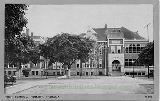
Yet Another View of the Old Hobart High School

The puppies are still disrupting my brainwaves, so here's a low-effort post: a view of the old Hobart High School that in some small way is different from all the other views I've posted:

2025-01-18. Hobart High School circa 1943 a
(Click on images to enlarge)

2025-01-18. Hobart High School circa 1943 b

The postcard was manufactured by Wayne Paper Box & Printing Corp., Fort Wayne, Indiana, so once we've gone through the Internet Archive Wayback Machine to retrieve a snapshot of the website I used to use to date this company's postcards and which has now disappeared from the internet — based on the "H" in the lower-right corner, and the gray border, I think we can date this postcard to around 1943 … although maybe that site was removed from the internet because it was inaccurate.[1]


Here are two sleeping puppies, a rare thing in my house these days:

2025-01-18. Boo and Smitty sleeping

_______________
[1] I am being facetious here.

Saturday, January 11, 2025

Puppies Interfering with History

2025-01-11. Boo
(Click on images to enlarge)

2025-01-11. Smitty

I was working on a new post for this blog, and making good progress, when I heard from the Humane Society of Hobart that they needed fosters for an incoming litter of pittie pups. I took two of the pups.

I would really like to finish my post, but we all know what happens to my brain when there are puppies in my house.

Thursday, January 2, 2025

The Lost Cemetery of Ainsworth Road

This post is based on research by local historian Michael White, who first pieced together the bits of information from various sources that pointed to an unaccounted-for old cemetery in Ross Township along with its general location. He was kind enough to clue me in.


The Rev. T.H. Ball, our legendary Lake County historian, in 1872[1] compiled a list of all the cemeteries he knew of in each township in the county. In the list for Ross Township, he included six cemeteries, five of which clearly correspond to ones we can identify today and can find in the Northwest Indiana Genealogical Society's Ross Township Cemeteries. But one item in Ball's list is a puzzler:
An old burial place near the Wilkinson Ford of Deep River, from which some bodies have been removed, but where many yet remain. This old spot is now part of a cultivated field. It seems a pity that the little ground required to receive the dust of human forms may not remain undisturbed. This spot ought yet to be rescued from the plowshire [sic], consecrated, as it has been, by the burial of old settlers; or the human remains there resting should be removed to a quiet cemetery which is sacred to repose.
Elsewhere in the same book, in listing early settlers of Lake County in the 1830s, Ball says: "The third family arriving was that of Robert Wilkinson, who settled on Deep River, where the only ford known in early times was situated."[2] (I have previously discussed my reasons for thinking that Ainsworth Road was part of the old Sauk Trail, predating white settlement. The indigenous people may have established the trail because there was a natural ford in the Deep River where Ainsworth Road crosses it — a natural ford that the white settlers would then have used as they trickled in along the trail during the 1830s.)

In another of his books, Ball tells us that in the 1830s a bridge "across Deep River at B. Wilkinson's crossing near the Porter county line [was] built by Amsi L. Ball, cost[ing] four hundred dollars."[3] So far we've heard only of Robert Wilkinson; who was B. Wilkinson? To find that out we have to turn to the "History of Lake County, 1833 – 1847" by Solon Robinson, as printed in 1929:[4]
The first family that came after Childers and myself [Solon Robinson] was that of Robert Wilkinson, (at the place where his brother Benijah now lives on Deep River; at that time, the only known crossing place.) He settled about the last of November, 1834. … Wilkinson lived a few years where he settled, when he moved off and his brother took his place.
So "B." stands for Benijah — or, as it is sometimes written, Benajah — and he succeeded his brother Robert on the settlement near the ford of the Deep River.[5]

Robinson's account includes, among a list of bridges built in 1837, a bridge "across Deep River at Benajah Wilkinson's [built] by A. L. Ball, for $400, besides several smaller ones, by means of the 3 per cent fund."[6]

Goodspeed and Blanchard's 1882 county history also mentions this $400 bridge built by A.L. Ball, and specifies that it was in "Section 16, Township 35, Range 7."[7]

Here is that section as it appears on the 1874 plat map:[8]

2025-01-02. Sec. 16, Twp. 35 N, Range 7 W (1874)
(Click on image to enlarge)

The only road that crossed the Deep River in Section 16 was Ainsworth Road, aka the old Sauk Trail.

Incidentally, Goodspeed and Blanchard tell us that in 1837 three township trustees were appointed for Twp. 35, Range 7 (Ross Township): John Wood, whom everybody knows; Robert Wilkinson; and William Hodson (whose orphaned sons I believe we've already met).[9] So Robert Wilkinson was still in Ross Township some three years after settling there.

The only early land purchase record I could find pertaining to the Wilkinson brothers and Section 16 shows Benajah buying 38 acres described as "Part Lot No. 5" on July 27, 1840.[10] That may have been the year Robert moved on.

Benajah appears in the 1840 census for the Ross Township area of Lake County;[11] his brother does not.

2025-01-02. 1840 census, Benajah Wilkinson
(Click on image to enlarge)
Image from Ancestry.com.


In August of 1849, Benajah Wilkinson died.

2025-01-02. U.S. Census Mortality Schedule for Indiana, 1850, Counties L-Z, p. 15
(Click on image to enlarge — a bit; sorry about the quality)
Image from Indiana State Library Digital Collections, U.S. Census Mortality Schedule for Indiana, 1850, Counties L-Z.


There is now no record of where he was buried. I am willing to bet that it was in the lost Wilkinson cemetery.

The 1850 census shows his widow, Prudence, and her children still in Ross Township.

2025-01-02. 1850 Census, Prudence Wilkinson
(Click on image to enlarge)
Image from Ancestry.com. Evidently the family was in Michigan in 1836 when their daughter, Electa, was born. The first of their children to be a native Hoosier was born in 1839.


Sometime after that they left Indiana.[12] Prudence died in 1885 in Minnesota.

♦    ♦    ♦

So where, exactly, is the lost cemetery? It was somewhere along Ainsworth Road, near the Deep River — but how near? which side of the road? which side of the river? I'm thinking that it would probably be on the west side of the river, because on the east side there is a long stretch of river bottom that often floods — but further east the land rises again, and we're back to not knowing how T.H. Ball measured his "near the Wilkinson Ford of Deep River."

It's just possible that his lament about plowing over consecrated ground might have spurred action. I have done a little searching in the on-line newspapers from 1873 onward for any story about relocating the remaining bodies from the Wilkinson cemetery, but I have found nothing.

Some of the land where the cemetery could possibly be now belongs to the Lake County Parks Department. In the years that I have lived here, I have spent many hours walking my dogs all over that land without ever seeing any evidence whatsoever of a cemetery — and, believe me, I am always on the lookout for interesting artifacts in the underbrush.

I suppose this will have to be one of the mysteries of Ainsworth.

_______________
[1] T.H. Ball, Lake County, Indiana, from 1834 to 1872 (Chicago: J.W. Goodspeed, 1873). The Ross Township burial places are listed at pp. 139-140.
[2] Ibid., p. 26.
[3] T.H. Ball, Encyclopedia of Genealogy and Biography of Lake County, Indiana, with a Compendium of History 1834 – 1904 (Chicago: The Lewis Publishing Company, 1904) (hereinafter, "Lake County Encyclopedia"), p. 10.
[4] Lake County Historical Association (John O. Bowers, Arthur G. Taylor, and Sam B. Woods, eds.), History of Lake County, Vol. 10 (Gary, Ind.: Calumet Press, 1929) (hereinafter, "Lake County, Vol. 10"). Solon Robinson's "Lake County, 1833 – 1847" starts on p. 35.
[5] Research on Robert Wilkinson is complicated by the fact that there were two early settlers by that name; in Ball's discussion in Lake County Encyclopedia at pp. 2-3 he mentions both, apparently distinguishing them. The one we're concerned with settled on Deep River for a short time, then gave his farm over to his brother and disappeared from history; the other settled in West Creek Township, and since he was more prominent in society and politics, more is written about him.
[6] Lake County, Vol. 10, p. 48.
[7] Weston A. Goodspeed and Charles Blanchard (eds.), Counties of Porter and Lake Indiana. Historical and Biographical. Illustrated (Chicago: F.A. Battey & Co., 1882), p. 422.
[8] Hardesty's Sectional Map of Lake Co. Indiana (Chicago: Rufus Blanchard, n.d. (the map's date is estimated at circa 1874)).
[9] Goodspeed and Blanchard at p. 421.
[10] Northwest Indiana Genealogical Society, Early Land Sales and Purchases, Lake County, Indiana, 1837 – 1857 (Valparaiso: Northwest Indiana Genealogical Society, 2006), p. 41.
[11] Yes, his name is written as "Benjamin," and no, the census does not specify the township, but among his neighbors are John Wood and some of the people who appeared in the NWIGS' listing of 1840s land purchases for Section 16, Twp. 35 N, Range 7 W.
[12] On Ancestry.com, I have found some records of Prudence Wilkinson buying land in Minnesota in 1860, but I cannot find the family in the 1860 census.